Step-by-Step Real-Time Geosteering Workflow (Rig to Office)
Jan 10, 2023· 2 minutes reading
In modern oil and gas drilling, especially in horizontal wells, success depends less on following a fixed plan and more on real-time decision-making. This is the foundation of geosteering, where the well path is continuously adjusted using real-time subsurface data to keep the borehole inside the most productive part of the reservoir.
Geosteering turns drilling into a dynamic, data-driven process where every drilled meter can change the next decision.
What is Real-Time Decision-Making in Geosteering?
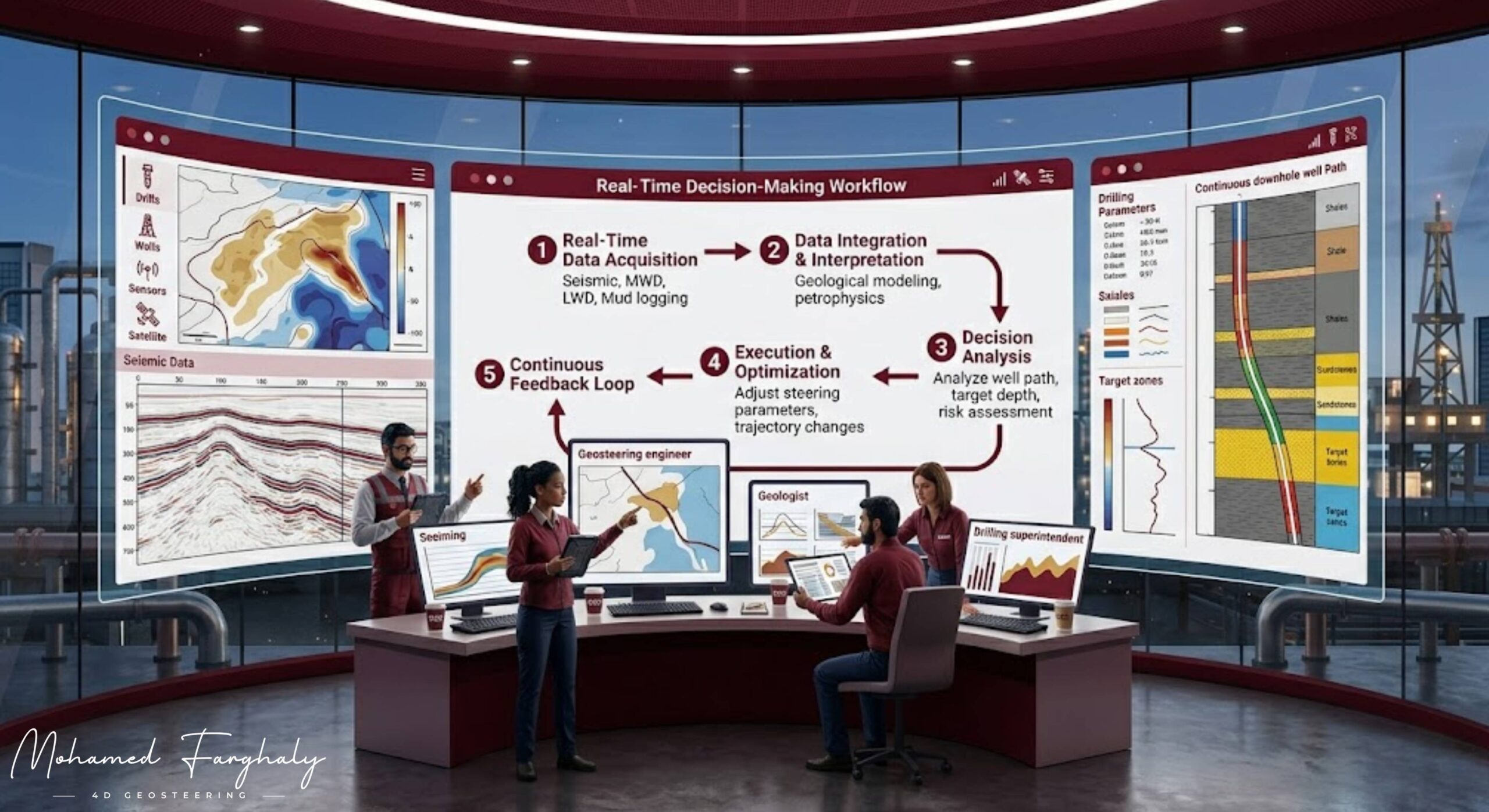
Real-time decision-making is a continuous loop that connects data, interpretation, and action during drilling. Instead of waiting until the end of drilling to evaluate results, engineers and geoscientists interpret data instantly and adjust the well trajectory on the fly.
The process includes:
- Collecting downhole data while drilling
- Interpreting formation signals in real time
- Updating the geological model continuously
- Making immediate steering decisions
The goal is to keep the wellbore within the target reservoir sweet spot despite geological uncertainty.
The Geosteering Workflow
1. Pre-Drilling Model
Before drilling starts, a geological model is built using seismic data, offset wells, and structural interpretation. This model predicts reservoir geometry, thickness, and boundaries, but it always contains uncertainty.
2. Real-Time Data Acquisition
While drilling, tools like Logging While Drilling (LWD) and Measurement While Drilling (MWD) continuously collect formation data such as gamma ray, resistivity, and density. This provides a real-time view of the formations surrounding the drill bit.
3. Real-Time Interpretation
The incoming data is compared with the expected model. Geoscientists interpret formation changes, identify boundaries, and detect whether the well is moving toward or away from the target zone. The model is updated continuously to reduce uncertainty.
4. Decision and Steering
Based on interpretation, the team makes immediate decisions:
- Continue drilling in the same direction
- Adjust inclination or azimuth
- Correct the well path to stay within the reservoir
This decision cycle repeats every few meters drilled.
The Closed-Loop System
Geosteering operates as a closed feedback loop:
Predict → Drill → Measure → Interpret → Update → Decide → Repeat
Each loop improves understanding of the subsurface and increases drilling accuracy in real time.
Why It Matters
Real-time decision-making in geosteering is critical because it:
- Maximizes reservoir exposure and production
- Avoids drilling into non-productive zones like shale or water
- Reduces drilling risks and costly errors
- Improves overall well placement efficiency
Even small trajectory adjustments can significantly impact production performance.
🔗 Keywords
Drilling Rig, Drilling Mud, MWD, LWD, Directional Drilling, Geosteering, Well Placement, Oil Reservoir, Surface Logging, Borehole Imaging, Electromagnetic Resistivity LWD Tool, Bottom Hole Assembly, Study of Real-Time LWD Data, LWD Interpretation, Borehole Image Log, Dip Calculation Methods, Shale Gas Sweet Spot, Accurate Reservoir Boundary Detection, Machine Learning, Artificial Intelligence, The Future of Automated Geosteering, Ensemble-Based Well Log Interpretation, Digital Twins in Drilling, Remote Operations Centers
