Logging While Drilling (LWD)
Sept 11, 2023· 3 minutes reading
Logging While Drilling (LWD) allows engineers to evaluate rock formations while the well is being drilled. It provides real-time measurements that support formation evaluation, Geosteering, Directional Drilling, and accurate Well Placement within the Oil Reservoir.
Unlike traditional wireline logging, which usually occurs after drilling, LWD collects data while the drill bit penetrates the formation. Engineers can therefore identify geological changes and make faster decisions before the well moves away from its target.
How Logging While Drilling Works
LWD tools are installed inside the Bottom Hole Assembly, close to the drill bit. This position allows them to measure recently drilled formations and deliver timely information about subsurface conditions.
Common LWD measurements include:
- Gamma ray
- Resistivity
- Density
- Neutron porosity
- Sonic response
- Formation pressure
- Borehole images
These measurements help geoscientists identify lithology, estimate porosity, evaluate fluid content, and locate potential hydrocarbon-bearing zones. When combined with MWD data, they also provide the directional information required to control the well trajectory.
LWD offers a major advantage over conventional wireline methods because drilling teams receive information sooner. As a result, they can respond quickly to formation changes, operational risks, and unexpected reservoir boundaries.
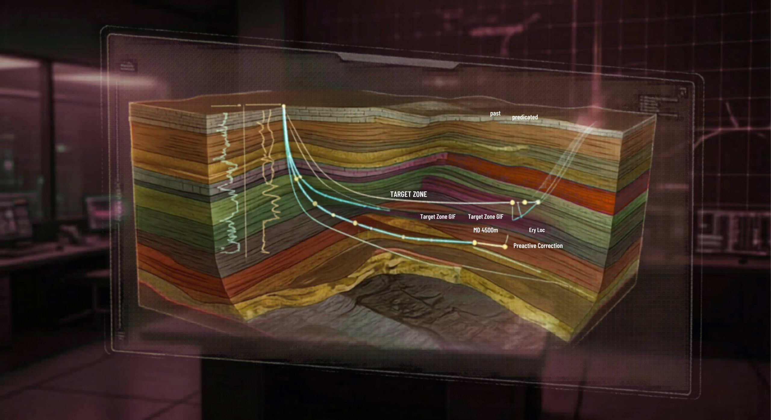
The Role of LWD in Geosteering
Geosteering is one of the most important applications of Logging While Drilling. During horizontal or directional drilling, real-time LWD data helps engineers determine whether the well remains inside the target reservoir interval.
If the measurements indicate that the well is approaching shale, water-bearing rock, or another unwanted formation, the team can adjust the trajectory. This continuous feedback helps maximize reservoir contact and improves the chance of reaching high-quality intervals, such as a Shale Gas Sweet Spot.
Advanced tools provide even greater geological awareness. For example, an Electromagnetic Resistivity LWD Tool can investigate the formation beyond the immediate wellbore. Its deep-reading measurements may detect approaching boundaries and support Accurate Reservoir Boundary Detection.
Borehole Imaging and Borehole Image Log technology provide another level of detail. These tools reveal bedding planes, fractures, faults, and structural orientation. Geoscientists can then apply Dip Calculation Methods to improve their understanding of reservoir geometry.
Turning Real-Time LWD Data into Better Decisions
The value of LWD depends on accurate analysis. Through LWD Interpretation and the Study of Real-Time LWD Data, specialists convert downhole measurements into practical drilling recommendations.
This process can help teams:
- Detect formation boundaries earlier
- Improve reservoir navigation
- Reduce geological uncertainty
- Avoid water-bearing or unstable zones
- Increase reservoir contact
- Minimize unnecessary drilling time
- Improve well safety and productivity
LWD becomes even more powerful when integrated with Surface Logging, MWD, and geological models. Together, these data sources create a clearer picture of the well and the surrounding formation.
Modern operations can transmit this information to Remote Operations Centers. There, geoscientists and drilling engineers monitor the well and collaborate with the rig team in real time. Machine Learning and Artificial Intelligence can also analyze data patterns, accelerate interpretation, and support The Future of Automated Geosteering.
Ultimately, Logging While Drilling is more than a formation measurement method. It allows drilling teams to see the reservoir as the well progresses. By turning real-time data into informed decisions, LWD supports safer drilling, more accurate well placement, and stronger production results.
🔗 Keywords
Drilling Rig, Drilling Mud, MWD, LWD, Directional Drilling, Geosteering, Well Placement, Oil Reservoir, Surface Logging, Borehole Imaging, Electromagnetic Resistivity LWD Tool, Bottom Hole Assembly, Study of Real-Time LWD Data, LWD Interpretation, Borehole Image Log, Dip Calculation Methods, Shale Gas Sweet Spot, Accurate Reservoir Boundary Detection, Machine Learning, Artificial Intelligence, The Future of Automated Geosteering, Ensemble-Based Well Log Interpretation, Digital Twins in Drilling, Remote Operations Centers
