Gamma Ray Sensors: Reading the Earth’s Natural Fingerprints
Sept 10, 2023· 3 minutes reading
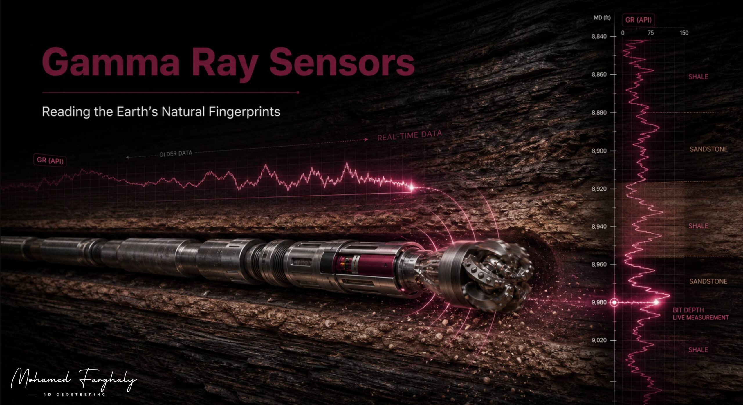
Every underground rock carries a natural signature formed over millions of years. Gamma ray sensors detect this signature while drilling and help engineers identify different rock types in real time. As a result, they are essential components of modern Logging While Drilling (LWD) systems.
How Gamma Ray Sensors Work
Gamma ray measurements detect natural radioactivity within geological formations. This radiation mainly comes from potassium, uranium, and thorium. Because each rock type contains different concentrations of these elements, its gamma ray response can reveal important changes in lithology.
Shales usually produce high gamma ray readings because they contain more radioactive minerals. In contrast, clean sandstones and carbonates often produce lower readings. Engineers use this difference to identify formation boundaries and correlate geological layers.
Gamma ray tools are installed inside the Bottom Hole Assembly, close to the drill bit. Therefore, they can continuously measure the formation as the drilling rig advances. This provides fresh subsurface information before significant borehole changes can affect the readings.
Gamma Ray Data in Geosteering
Gamma ray data plays an important role in geosteering and directional drilling. It helps geosteering teams understand which formation the drill bit is passing through. It also supports more accurate well placement within the target reservoir.
During horizontal drilling, small changes in gamma ray values can indicate movement toward or away from the planned interval. For example, a sudden increase may suggest that the wellbore is approaching a shale layer. The drilling team can then adjust the trajectory before leaving the productive zone.
This rapid response helps maintain reservoir contact. It may also reduce the risk of drilling into unwanted shale barriers, unstable formations, or water-bearing zones.
Gamma ray data becomes even more valuable when combined with other LWD measurements. Resistivity can indicate changes in fluid content, while density and neutron measurements help estimate porosity. Together, these measurements provide a clearer picture of formation quality.
In addition, gamma ray curves support real-time LWD interpretation and well-to-well correlation. Engineers can compare the live curve with data from offset wells. Consequently, they can identify formation shifts and update the geological model while drilling continues.
Advanced Interpretation and Automation
In complex reservoirs, gamma ray trends can be integrated with borehole imaging data. Borehole images reveal bedding, fractures, faults, and structural orientation. Meanwhile, the gamma ray response helps distinguish lithological changes. This combination improves reservoir boundary detection and supports better steering decisions.
Gamma ray measurements can also contribute to shale gas sweet spot identification. Organic-rich shale intervals may produce distinctive responses. However, gamma ray data should be evaluated with resistivity, density, porosity, and other formation measurements before a sweet spot is confirmed.
Modern workflows integrate gamma ray information with MWD, surface logging, and real-time analytics. Machine learning and artificial intelligence can recognize patterns across large datasets. They may also improve interpretation speed and highlight changes that require expert attention.
In remote operations centers, geologists and drilling engineers monitor these measurements continuously. This allows them to collaborate and respond quickly, even when they are located far from the rig. Furthermore, the same data supports the development of automated and AI-assisted geosteering systems.
Ultimately, gamma ray sensors translate the Earth’s natural radioactivity into useful geological information. They help engineers identify rock types, detect formation boundaries, and improve real-time well placement. By combining gamma ray data with other LWD measurements, drilling teams can understand the subsurface more clearly and steer wells with greater confidence.
🔗 Keywords
Drilling Rig, Drilling Mud, MWD, LWD, Directional Drilling, Geosteering, Well Placement, Oil Reservoir, Surface Logging, Borehole Imaging, Electromagnetic Resistivity LWD Tool, Bottom Hole Assembly, Study of Real-Time LWD Data, LWD Interpretation, Borehole Image Log, Dip Calculation Methods, Shale Gas Sweet Spot, Accurate Reservoir Boundary Detection, Machine Learning, Artificial Intelligence, The Future of Automated Geosteering, Ensemble-Based Well Log Interpretation, Digital Twins in Drilling, Remote Operations Centers
