Impact on Reservoir Contact: How Geosteering Optimizes Production
April 11, 2023· 2 minutes reading
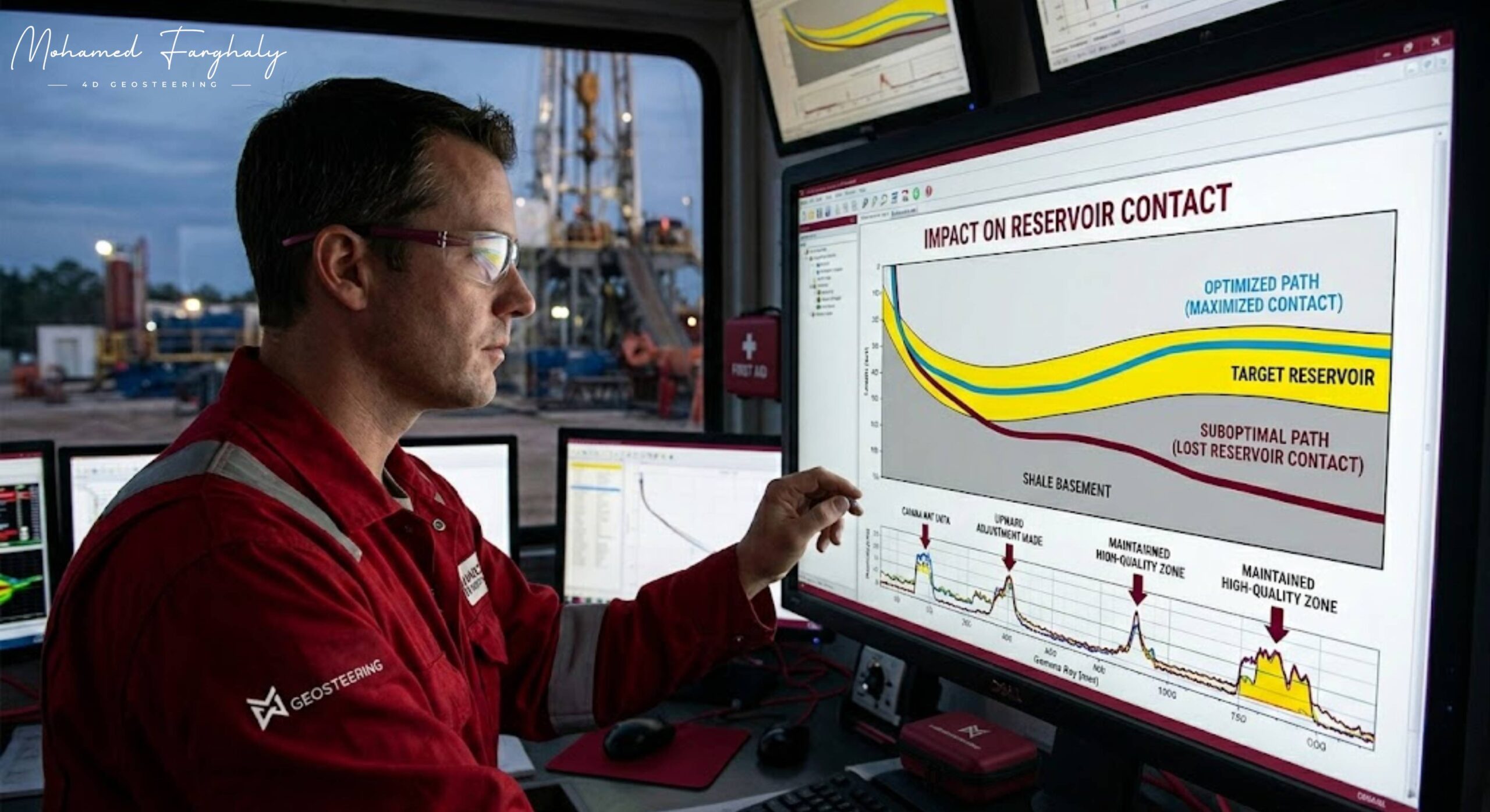
When a well is drilled, the ultimate goal is not just to reach the reservoir, but to stay within the most productive part of it for as long as possible. This is where reservoir contact becomes a critical concept. Reservoir contact refers to how much of the wellbore actually stays within the hydrocarbon-bearing zone. The higher the contact, the greater the chance of efficient production.
Geosteering plays a direct role in maximizing this contact. It is the real-time process of adjusting the well trajectory based on subsurface data while drilling. Instead of following a fixed plan, the well path is continuously updated using measurements such as gamma ray, resistivity, and formation density. These inputs help geoscientists and drilling engineers understand where the bit is relative to the reservoir boundaries.
One of the most important impacts of geosteering is its ability to prevent “out-of-zone” drilling. Even small deviations can push the well into non-productive layers such as shale or water-bearing zones. By staying within the sweet spot of the reservoir, geosteering increases net pay exposure and reduces drilling of non-productive intervals.
Another key benefit is improved reservoir drainage efficiency. A well with higher reservoir contact can drain hydrocarbons more evenly, reducing the number of wells needed in a field development plan. This directly translates into lower development costs and higher recovery factors.
Geosteering also enhances decision-making in complex geological settings where layers are thin, dipping, or highly heterogeneous. Without real-time adjustments, traditional drilling may miss significant portions of the reservoir. With geosteering, operators can “follow” the reservoir geometry instead of cutting across it blindly.
In essence, reservoir contact measures how effectively teams utilize the subsurface resource. Geosteering transforms this from a static drilling objective into a dynamic optimization process, ensuring that every meter drilled contributes to maximum hydrocarbon recovery.
🔗 Keywords
Drilling Rig, Drilling Mud, MWD, LWD, Directional Drilling, Geosteering, Well Placement, Oil Reservoir, Surface Logging, Borehole Imaging, Electromagnetic Resistivity LWD Tool, Bottom Hole Assembly, Study of Real-Time LWD Data, LWD Interpretation, Borehole Image Log, Dip Calculation Methods, Shale Gas Sweet Spot, Accurate Reservoir Boundary Detection, Machine Learning, Artificial Intelligence, The Future of Automated Geosteering, Ensemble-Based Well Log Interpretation, Digital Twins in Drilling, Remote Operations Centers
