Porosity measurement principles
Sept 1, 2023· 3 minutes reading
In oil and gas exploration, understanding reservoir quality is essential for placing wells in the most productive zones. One of the key petrophysical properties used in geosteering and formation evaluation is porosity, which defines the rock’s ability to store hydrocarbons.
Porosity measurement principles help geoscientists and engineers evaluate the available pore space inside the formation. These measurements support real-time drilling decisions, especially when navigating complex reservoirs with changing geological conditions.
What Is Porosity?
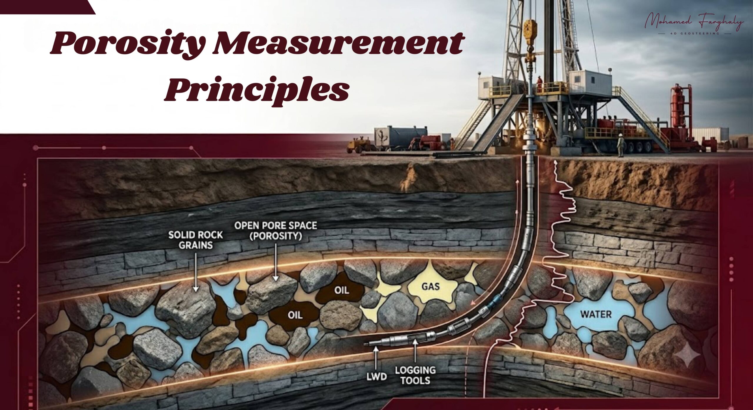
Porosity is the percentage of pore space within a rock compared to its total bulk volume. These pores can contain fluids such as oil, gas, and water.
High-porosity formations usually have greater storage capacity, while low-porosity formations may hold fewer hydrocarbons. However, reservoir performance depends not only on porosity but also on pore connectivity and permeability, which control fluid movement through the rock.
Types of Porosity in Reservoir Evaluation
During petrophysical analysis, porosity is mainly classified into:
Total Porosity:
Includes all pore spaces within the rock, including isolated pores that may not contribute to fluid flow.
Effective Porosity:
Represents the connected pore spaces that allow hydrocarbons and fluids to move through the formation. This type is highly important for reservoir evaluation and geosteering decisions.
Core-Based Porosity Measurements
Core analysis provides direct measurements of rock properties by examining extracted formation samples. Laboratory techniques determine porosity by measuring grain volume, bulk volume, and pore volume.
Core porosity data is valuable for understanding the actual reservoir rock and calibrating logging interpretations. However, core samples represent limited points along the well, while logging provides continuous formation information.
Log-Based Porosity Estimation
During drilling operations, especially in geosteering, porosity is commonly estimated using Logging While Drilling (LWD) measurements.
Important porosity-related logging methods include:
- Density Logs: Measure formation density and estimate porosity by comparing rock matrix and fluid densities.
- Neutron Logs: Detect hydrogen concentration to evaluate pore fluid presence and estimate porosity.
- Sonic Logs: Use acoustic travel time through the formation to calculate porosity.
- Nuclear Magnetic Resonance (NMR): Provides information about pore fluids, pore size distribution, and movable hydrocarbons.
These real-time measurements help geosteering teams recognize changes in reservoir quality and adjust the well trajectory when needed.
Role of Porosity in Geosteering
In horizontal drilling, keeping the wellbore inside the most productive reservoir zone is critical. Porosity measurements help geosteering teams:
- Detect changes in reservoir properties
- Identify formation boundaries
- Maintain the well path within high-quality zones
- Improve hydrocarbon recovery potential
By integrating porosity with other measurements such as gamma ray, resistivity, and geological models, engineers can make faster and more accurate well placement decisions.
Challenges Affecting Porosity Measurements
Porosity interpretation can be influenced by several geological and operational factors, including:
- Changes in lithology
- Clay content variations
- Natural fractures and vugs
- Borehole conditions
- Different fluid types inside pore spaces
Because of these challenges, petrophysicists combine multiple measurements to achieve a more reliable evaluation of reservoir properties.
🔗 Keywords
Drilling Rig, Drilling Mud, MWD, LWD, Directional Drilling, Geosteering, Well Placement, Oil Reservoir, Surface Logging, Borehole Imaging, Electromagnetic Resistivity LWD Tool, Bottom Hole Assembly, Study of Real-Time LWD Data, LWD Interpretation, Borehole Image Log, Dip Calculation Methods, Shale Gas Sweet Spot, Accurate Reservoir Boundary Detection, Machine Learning, Artificial Intelligence, The Future of Automated Geosteering, Ensemble-Based Well Log Interpretation, Digital Twins in Drilling, Remote Operations Centers, porosity measurement principles, petrophysical properties analysis, reservoir characterization, geosteering, LWD porosity, formation evaluation, oil and gas reservoir properties
