Borehole Image Log Technology
June 11, 2025 · 2 minutes reading
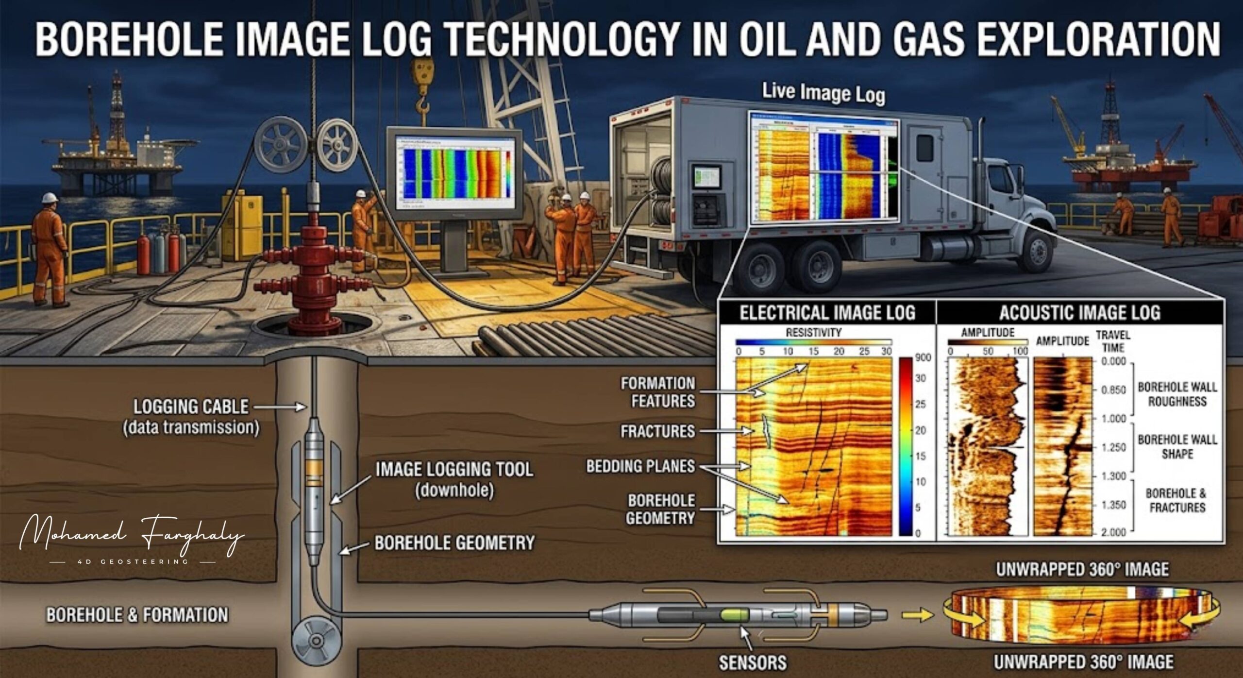
What if geosteering was not only based on data, but also on actual images of the formation? That is exactly what Borehole Image Log Technology brings to modern geosteering operations — the ability to visualize the subsurface and make more accurate geosteering decisions.
In advanced drilling operations, borehole image logs provide high-resolution images of the wellbore wall. These images reveal critical geological features such as bedding planes, fractures, faults, and formation textures. In geosteering, this visual information adds a deeper level of understanding that goes beyond standard log measurements.
Unlike conventional Logging While Drilling (LWD) data, which provides indirect measurements, borehole image log technology offers structural insight. This is essential for geosteering, where understanding formation dip, direction, and orientation directly impacts well placement and trajectory control.
The role of borehole imaging in geosteering becomes even more important in complex reservoirs. In thin beds or highly fractured formations, small structural variations can significantly affect geosteering accuracy. By using borehole images, geosteerers can detect these variations early and adjust the well path accordingly.
When integrated with Measurement While Drilling (MWD) and LWD, borehole image log technology strengthens the entire geosteering workflow. MWD provides the well trajectory, LWD provides formation properties, and borehole imaging adds structural clarity. Together, they enable precise and confident geosteering decisions.
One of the key advantages of borehole image logs in geosteering is the ability to identify natural fractures and stress patterns. These features influence both drilling performance and reservoir productivity, making them essential for optimizing well placement and improving long-term results.
Many overlook the importance of visual data in geosteering, focusing only on numerical logs. However, borehole image log technology transforms interpretation by turning data into a visual representation of the subsurface, improving both accuracy and confidence in geosteering operations.
If you want to take geosteering to a higher level of precision, start with Borehole Image Log Technology. It is where data becomes visualization, and visualization leads to smarter geosteering decisions.
🔗 Keywords
Drilling Rig, Drilling Mud, MWD, LWD, Directional Drilling, Geosteering, Well Placement, Oil Reservoir, Surface Logging, Borehole Imaging, Electromagnetic Resistivity LWD Tool, Bottom Hole Assembly, Study of Real-Time LWD Data, LWD Interpretation, Borehole Image Log, Dip Calculation Methods, Shale Gas Sweet Spot, Accurate Reservoir Boundary Detection, Machine Learning, Artificial Intelligence, The Future of Automated Geosteering, Ensemble-Based Well Log Interpretation, Digital Twins in Drilling, Remote Operations Centers
