Azimuth Control in Geosteering
June 4, 2023· 2 minutes reading
Achieving precise azimuth control in geosteering is a critical requirement for successful horizontal and directional drilling. In the modern oil and gas industry, the ability to maintain the correct wellbore path determines whether a project meets its production targets or suffers from costly operational delays.
What is Azimuth in Directional Drilling?
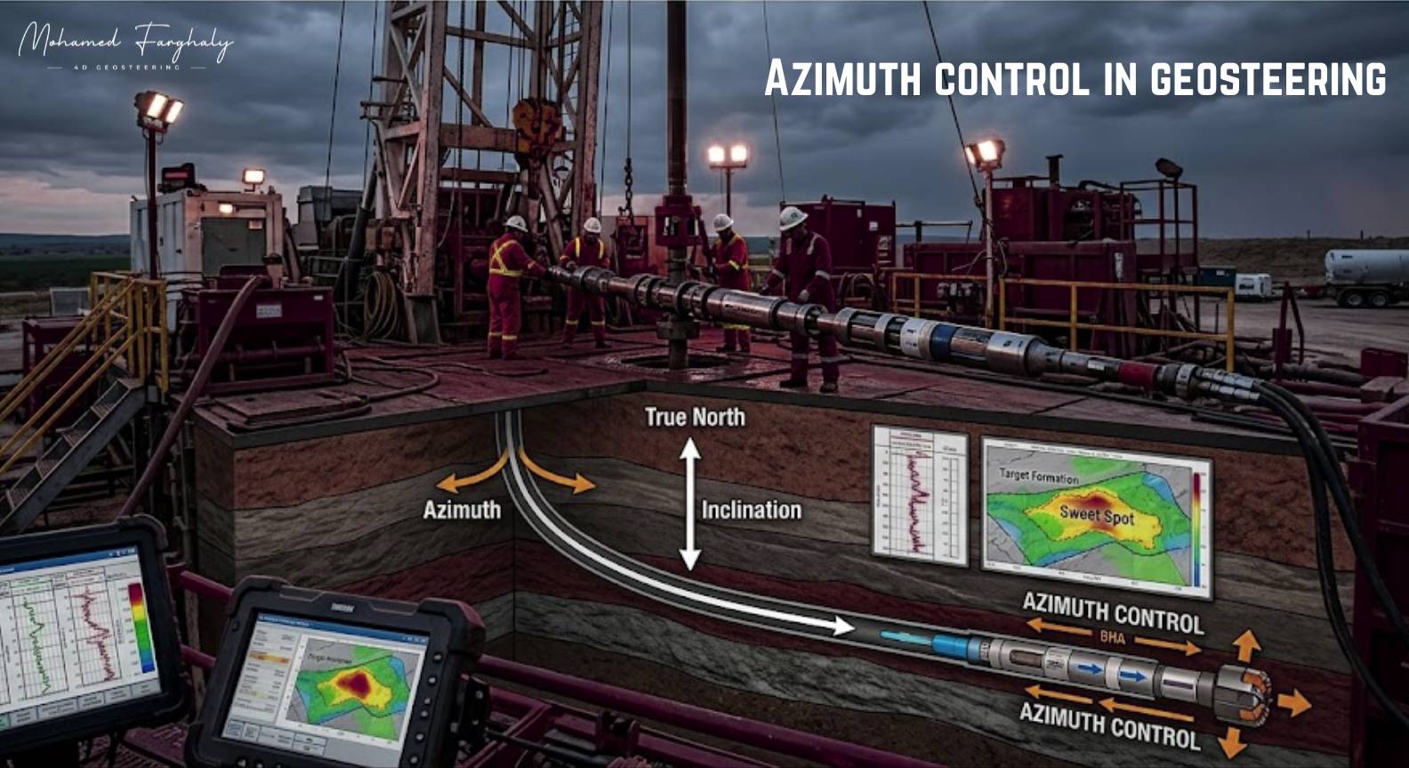
Azimuth is the horizontal direction of the wellbore, measured as an angle from a reference point—typically True North. While inclination handles the vertical trajectory, azimuth manages the left-to-right path. For professionals, mastering this metric is the key to navigating around geological hazards and ensuring the bit stays within the reservoir’s “sweet spot.”
Why Precise Azimuth Control Matters
Maintaining accurate trajectory is not just about staying in the formation; it is about efficiency and asset integrity. Effective control impacts the project in three primary ways:
- Optimized Reservoir Connectivity: Precise tracking ensures the lateral section remains within high-permeability, oil-saturated facies.
- Anti-Collision Management: In multi-well pad drilling, accurate azimuth prevents dangerous intersections with existing wellbores.
- Reduced Tortuosity: Proper steering minimizes erratic path adjustments, reducing torque and drag. This makes running casing and production equipment significantly safer and faster.
Core Techniques for Managing Azimuth
Controlling the well path requires a blend of advanced technology and experienced interpretation.
1. Utilizing Rotary Steerable Systems (RSS)
Modern operations prioritize RSS technology. Unlike mud motors that require “sliding”—which significantly increases drag—an RSS allows for continuous rotation. This results in a smoother borehole and allows for active, incremental adjustments to the azimuth without stopping the drill string.
2. Compensating for Formation Dip and Bit Walk
Drill bits often experience “bit walk,” a natural tendency to drift due to mechanical interaction with the formation. Experienced directional drillers manage this by applying a “lead angle,” intentionally pointing the bit off-center to counteract natural drift. Furthermore, by analyzing Logging While Drilling (LWD) data, engineers can adjust the azimuth before exiting the target zone.
3. Proactive vs. Reactive Steering
The most successful geosteering workflows are proactive. By monitoring the rate of change in your LWD resistivity and gamma-ray curves, you can identify boundary approaches early and steer into the zone at a shallow angle, rather than waiting for a hard signal to correct the path.
Best Practices for Geosteerers
- Integrate Data: Always combine real-time survey data with seismic maps and offset well logs to maintain a 3D mental model of the subsurface.
- Maintain Communication: Success relies on the loop between the geologist interpreting the logs and the directional driller operating the RSS.
- Continuous Monitoring: Never rely on static models; formation conditions change, and real-time adjustments are the hallmark of a high-performing geosteering operation.
🔗 Keywords
Drilling Rig, Drilling Mud, MWD, LWD, Directional Drilling, Geosteering, Well Placement, Oil Reservoir, Surface Logging, Borehole Imaging, Electromagnetic Resistivity LWD Tool, Bottom Hole Assembly, Study of Real-Time LWD Data, LWD Interpretation, Borehole Image Log, Dip Calculation Methods, Shale Gas Sweet Spot, Accurate Reservoir Boundary Detection, Machine Learning, Artificial Intelligence, The Future of Automated Geosteering, Ensemble-Based Well Log Interpretation, Digital Twins in Drilling, Remote Operations Centers
