Continuous Model Updating From Field Data
Dec 17, 2023· 3 minutes reading
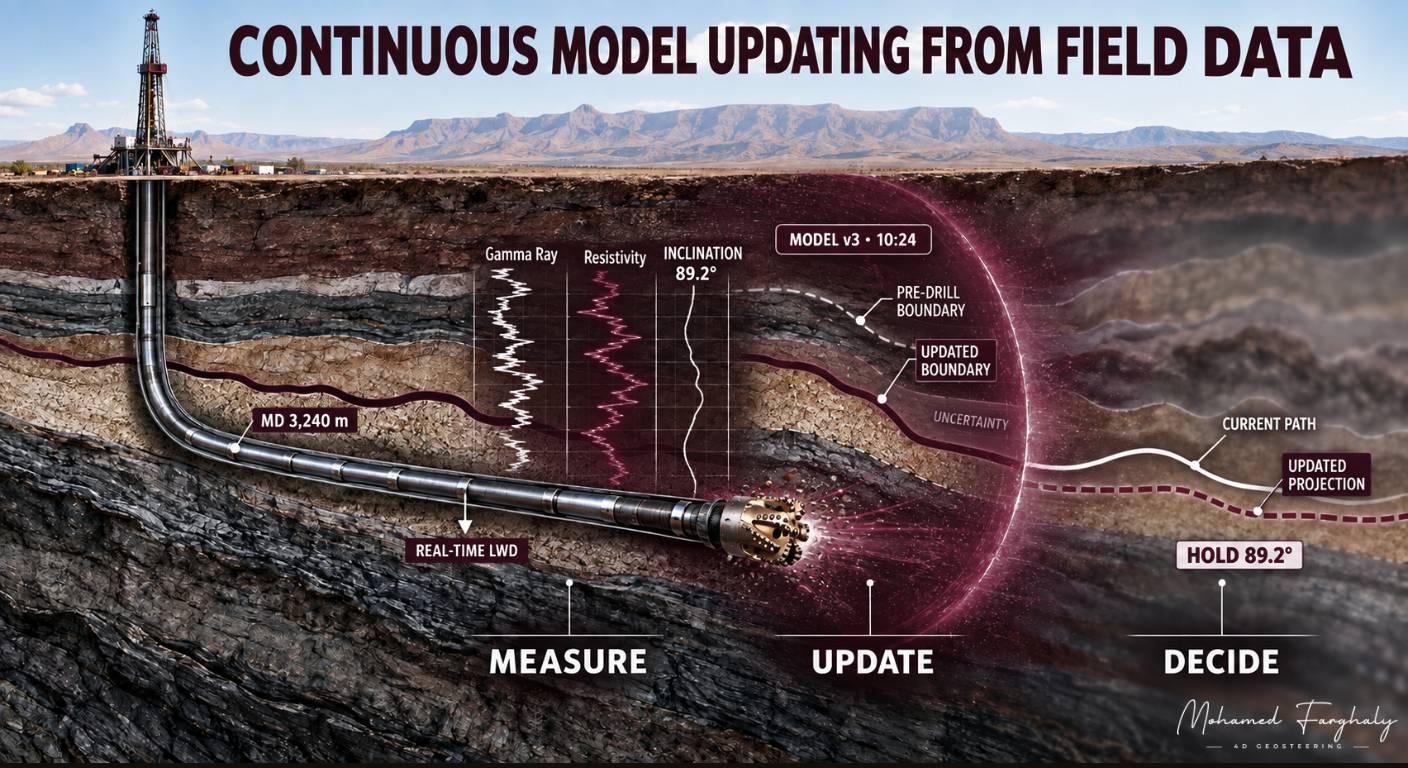
A subsurface model represents the best geological understanding available before drilling begins. However, the actual formation may differ from the initial interpretation. Continuous model updating from field data allows the geosteering team to replace assumptions with evidence as the drill bit advances.
Instead of treating the pre-drill model as fixed, the team continuously compares predicted geology with real measurements. Consequently, the model becomes more accurate with every new section drilled.
How Field Data Updates the Model
The updating process begins when the drilling system transmits new field data. These inputs may include gamma ray, resistivity, density, inclination, azimuth and drilling parameters. In addition, image logs can provide information about structural dip and formation boundaries.
First, the team checks the incoming data for depth accuracy, correct units, transmission delays and missing values. Reliable quality control is essential because incorrect field data could move a geological boundary to the wrong position.
Next, geologists correlate the measured log response with offset-well markers and the expected formation sequence. If a marker appears earlier or later than predicted, they adjust its depth in the model. Likewise, they may revise bed thickness, structural dip or fault position when the real-time response reveals an unexpected change.
The updated interpretation then replaces the earlier version while preserving the original model for comparison. Therefore, the team can track what changed, why it changed and which evidence supported the revision.
Improving Decisions While Drilling
Continuous model updating helps the team understand the well’s current position relative to the target reservoir. For example, a changing gamma-ray or resistivity response may indicate that the bit is approaching the reservoir roof or floor.
After updating the formation boundary, the team projects the current trajectory through the revised model. If the planned path could leave the target, the geosteering specialist can recommend holding, building or dropping inclination. The directional drilling team can then evaluate whether the adjustment is operationally achievable.
Moreover, every update reduces uncertainty ahead of the bit. The model will never remove geological uncertainty completely. Nevertheless, regular updates prevent the team from making decisions based on outdated assumptions.
Automated tools can accelerate this process by combining real-time LWD measurements with geological and seismic information. However, experienced specialists must still validate the data and interpretation before approving major trajectory changes.
Ultimately, continuous model updating from field data creates a living representation of the subsurface. It connects each new measurement with the next drilling decision, helping the team respond earlier and keep the well within the most valuable part of the reservoir.
🔗 Keywords
Drilling Rig, Drilling Mud, MWD, LWD, Directional Drilling, Geosteering, Well Placement, Oil Reservoir, Surface Logging, Borehole Imaging, Electromagnetic Resistivity LWD Tool, Bottom Hole Assembly, Study of Real-Time LWD Data, LWD Interpretation, Borehole Image Log, Dip Calculation Methods, Shale Gas Sweet Spot, Accurate Reservoir Boundary Detection, Machine Learning, Artificial Intelligence, The Future of Automated Geosteering, Ensemble-Based Well Log Interpretation, Digital Twins in Drilling, Remote Operations Centers