• Manual vs Automated Geosteering: Which Strategy Is Best ?

    May 27, 2023· 3 minutes reading

    In the oil and gas industry, the ability to keep a wellbore accurately positioned within a productive reservoir can significantly impact production performance and project economics. Traditionally, this task has been performed by experienced geosteerers who analyze real-time data and make steering decisions based on their geological understanding. Today, however, geosteering automation is changing the way wells are drilled by introducing advanced algorithms, artificial intelligence, and automated decision-support systems.

    While both approaches aim to maximize reservoir contact and improve drilling efficiency, they operate in very different ways and each has unique strengths and limitations.

    Manual Geosteering: The Human-Driven Approach

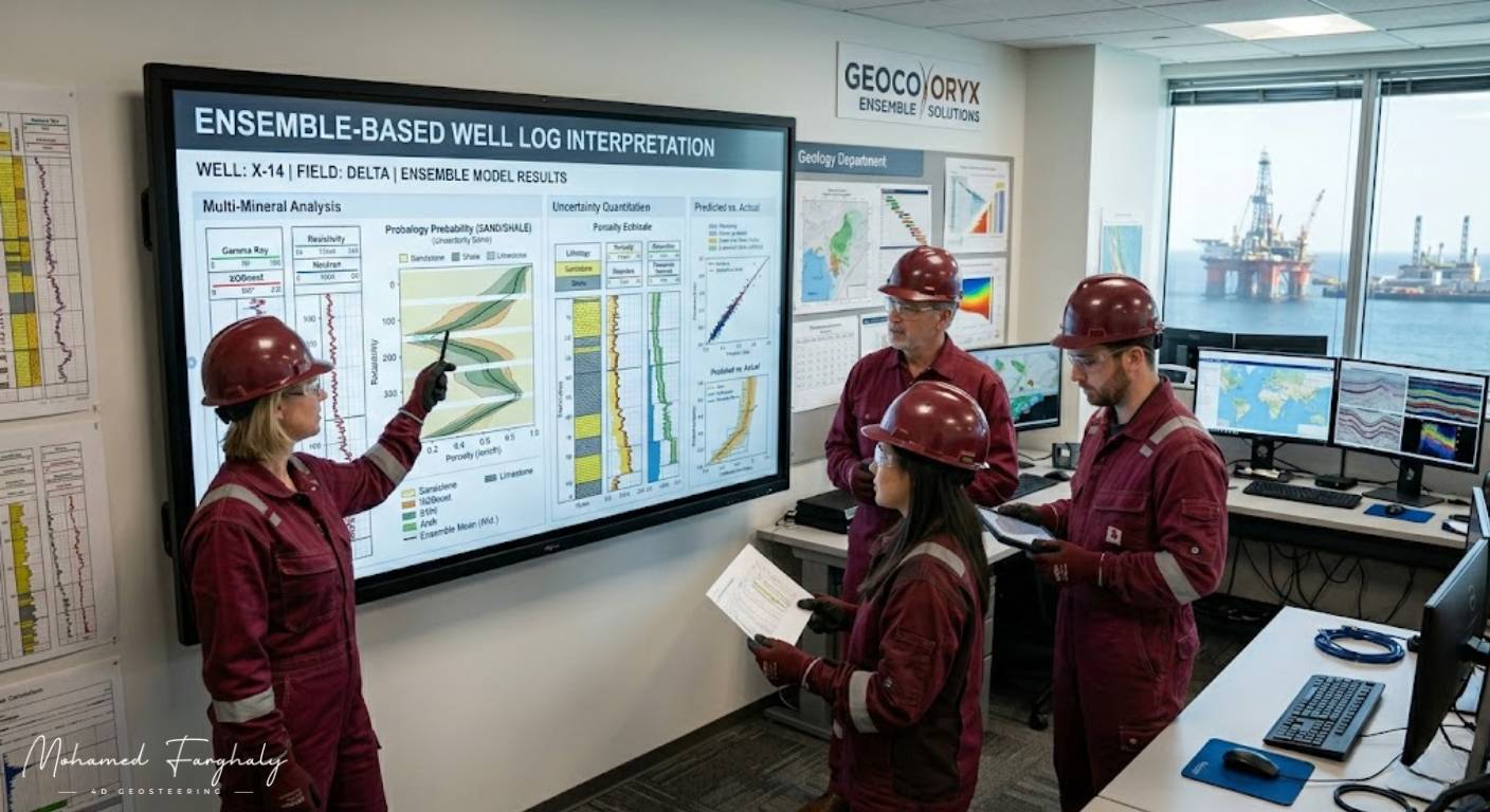
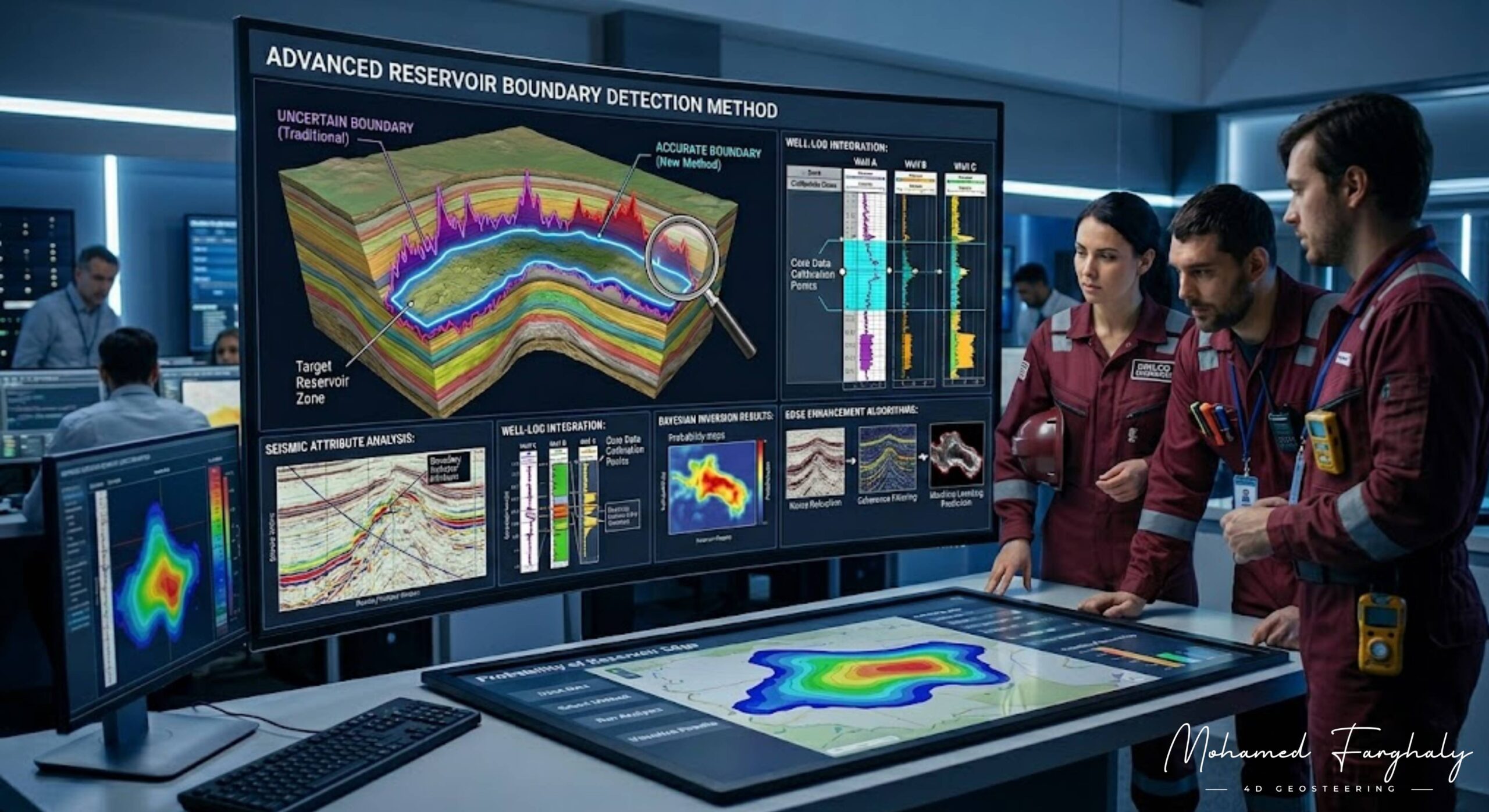
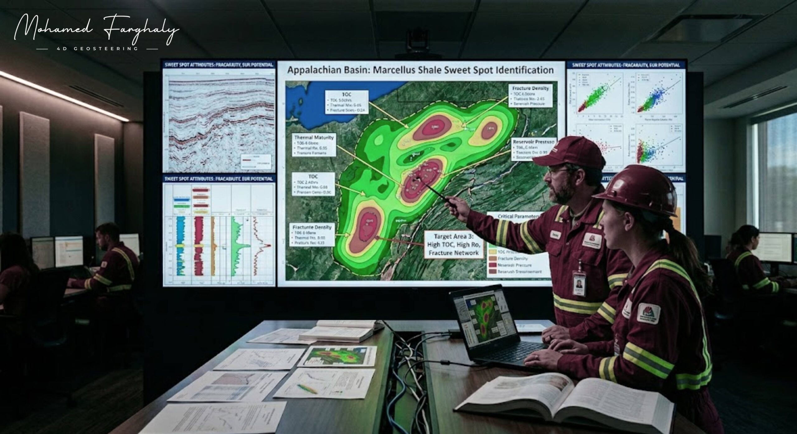
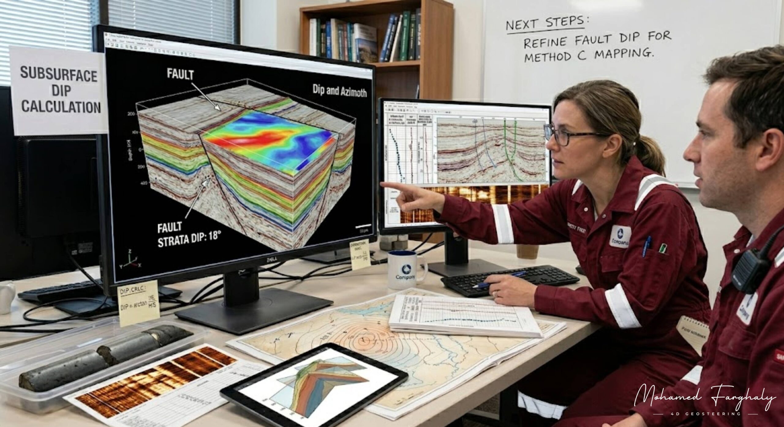
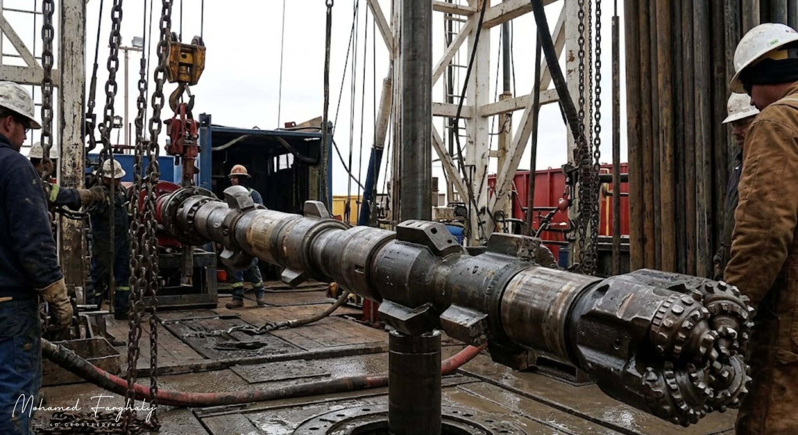
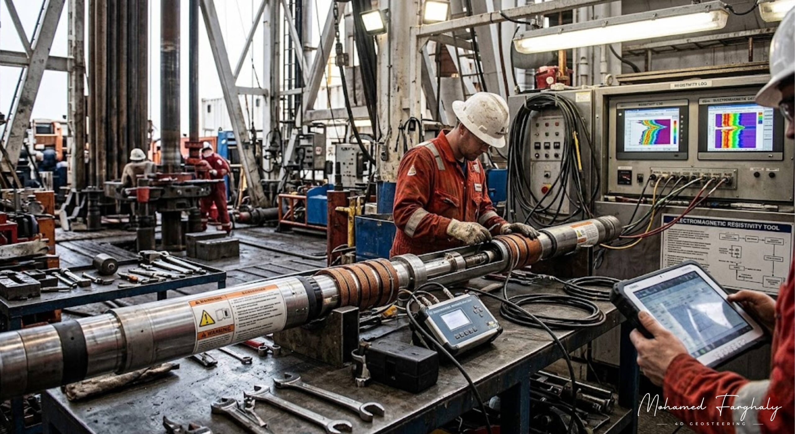
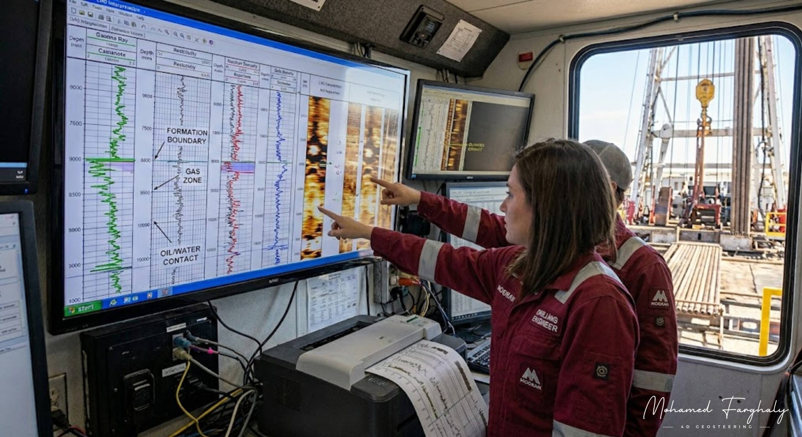
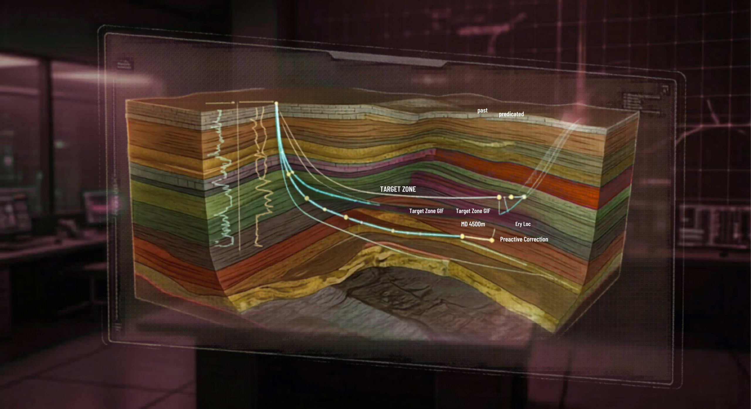
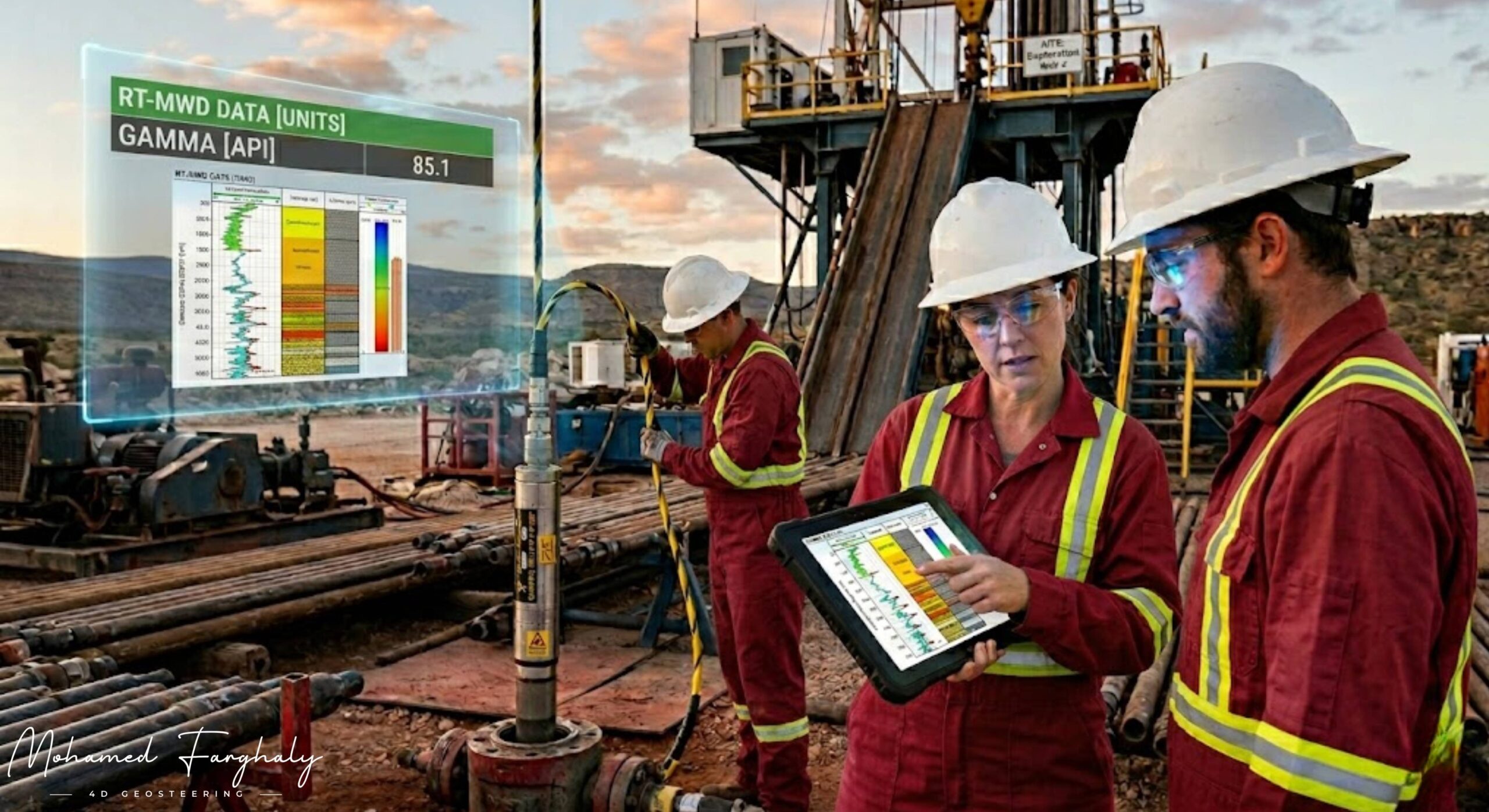
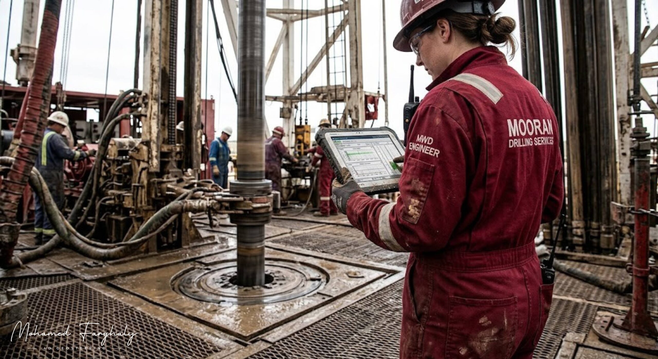
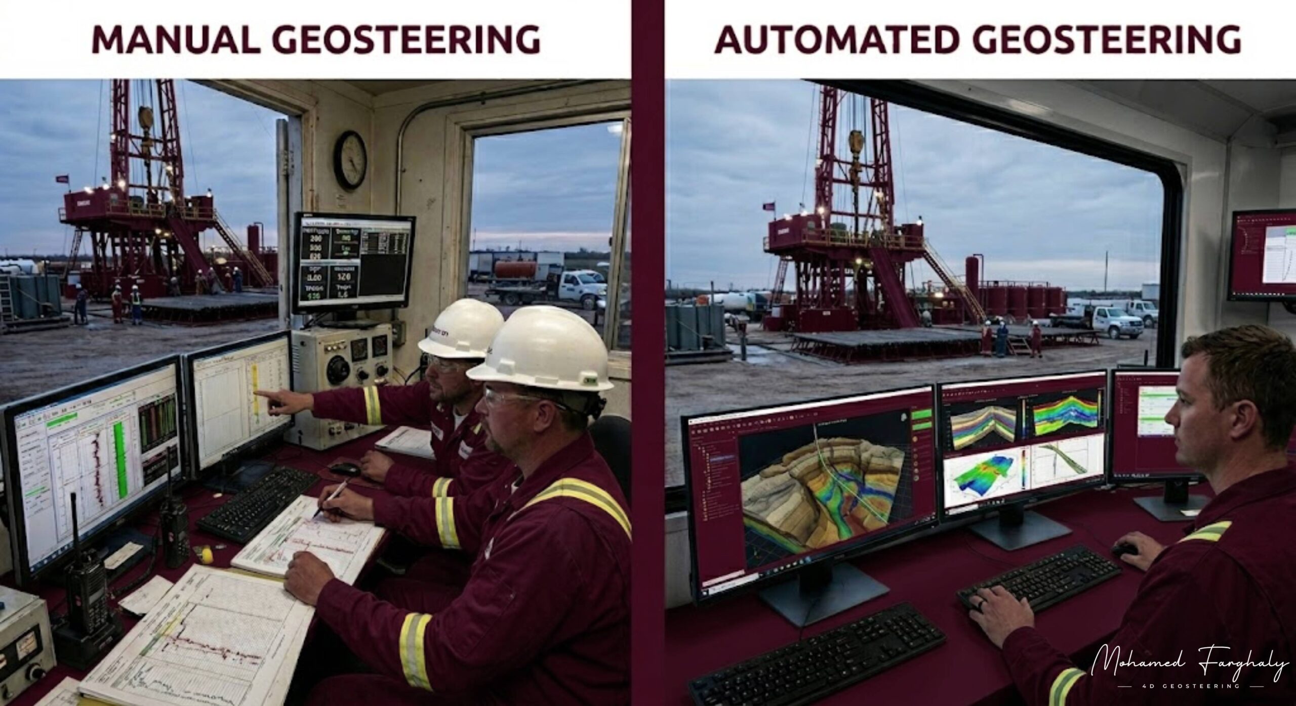
    Manual geosteering relies on geologists and geosteering specialists to interpret Logging While Drilling (LWD) measurements, geological models, offset well data, and drilling information in real time. Based on their interpretation, they recommend trajectory adjustments to keep the well within the target formation.

    One of the greatest strengths of manual geosteering is the ability to apply geological expertise and critical thinking. Experienced geosteerers can recognize subtle geological changes, identify unexpected formation behavior, and adjust interpretations when actual conditions differ from the pre-drill model.

    Manual workflows are particularly valuable in reservoirs with complex structures, faulting, variable stratigraphy, or limited historical data. Human experts can integrate multiple sources of information and make decisions that go beyond predefined rules.

    However, manual geosteering can be slower because every interpretation requires human analysis. It may also introduce variability since different geosteerers can reach different conclusions when reviewing the same data.

    Automated Geosteering: The Technology-Driven Approach

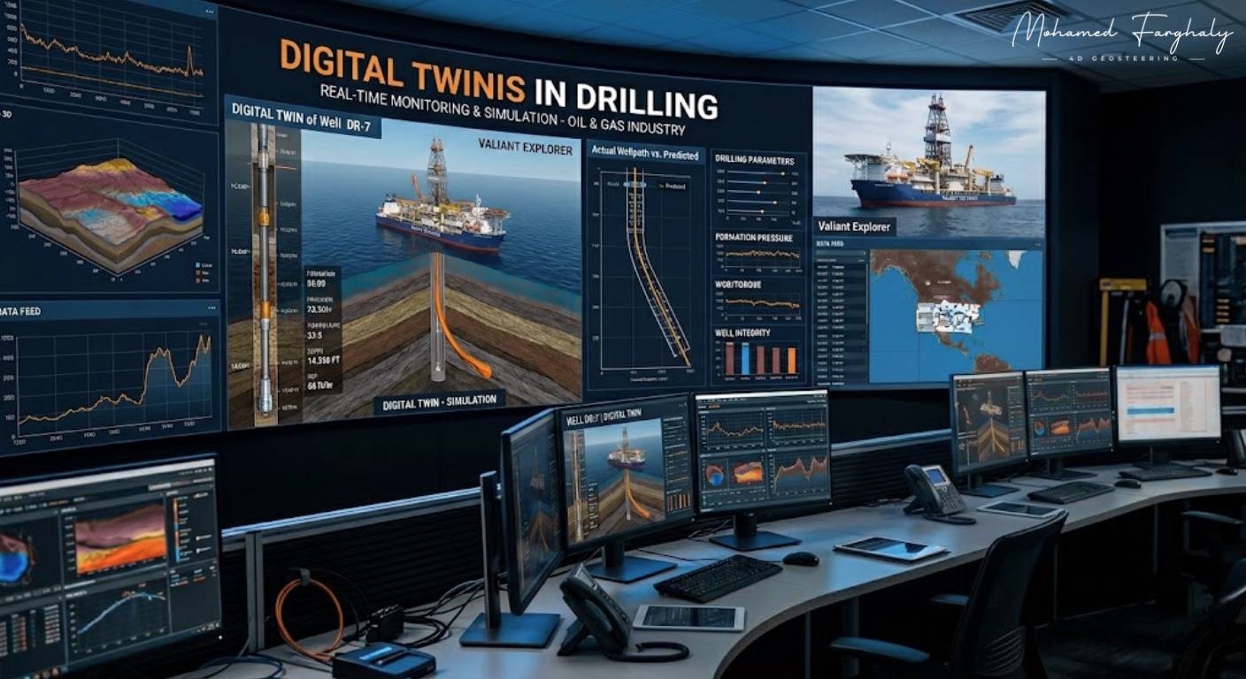
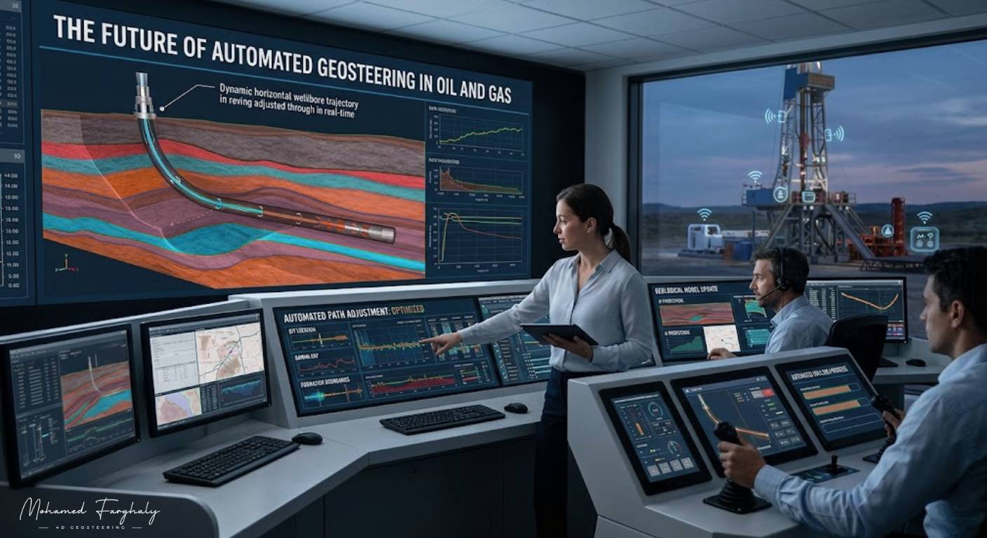
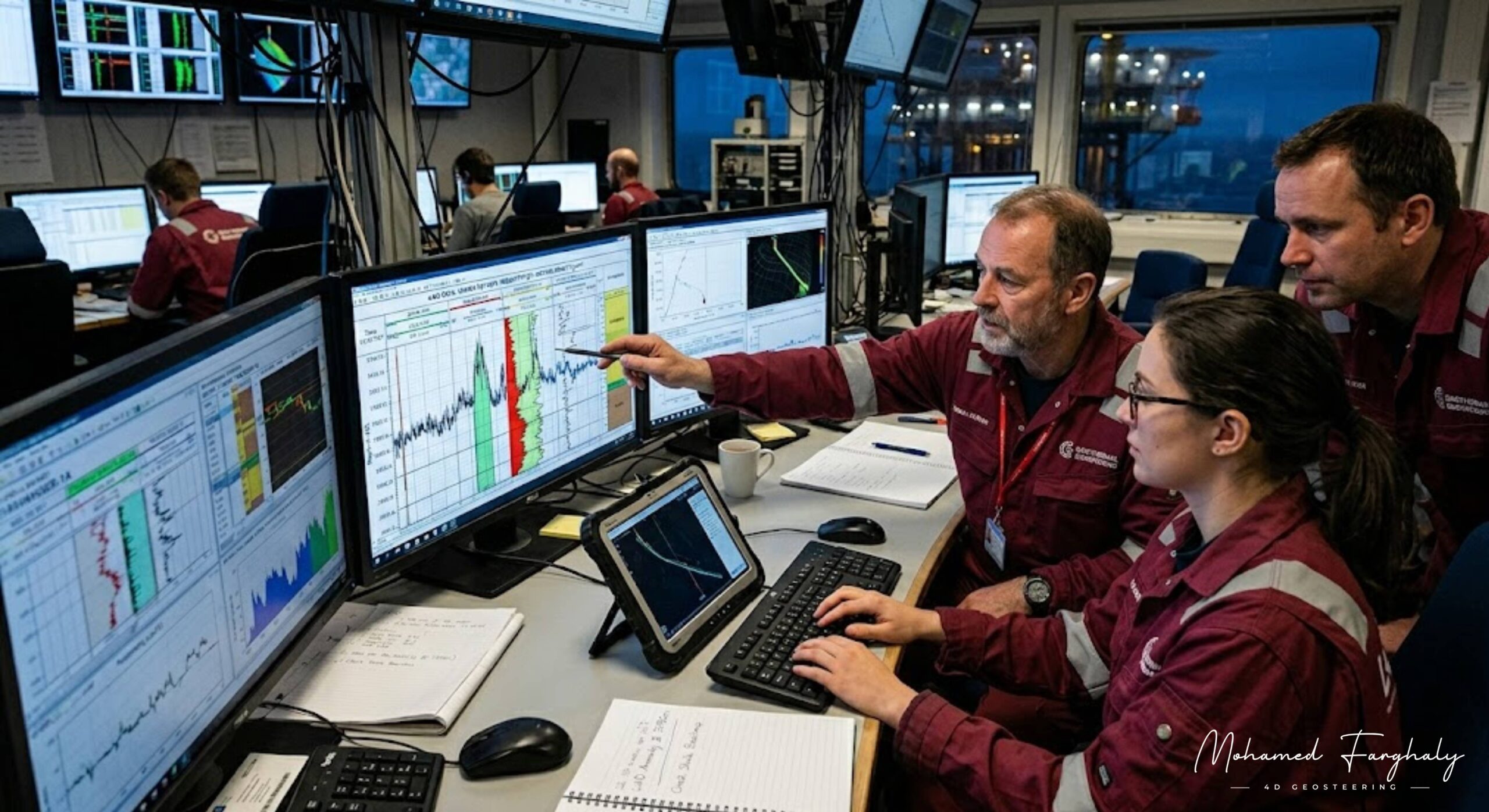
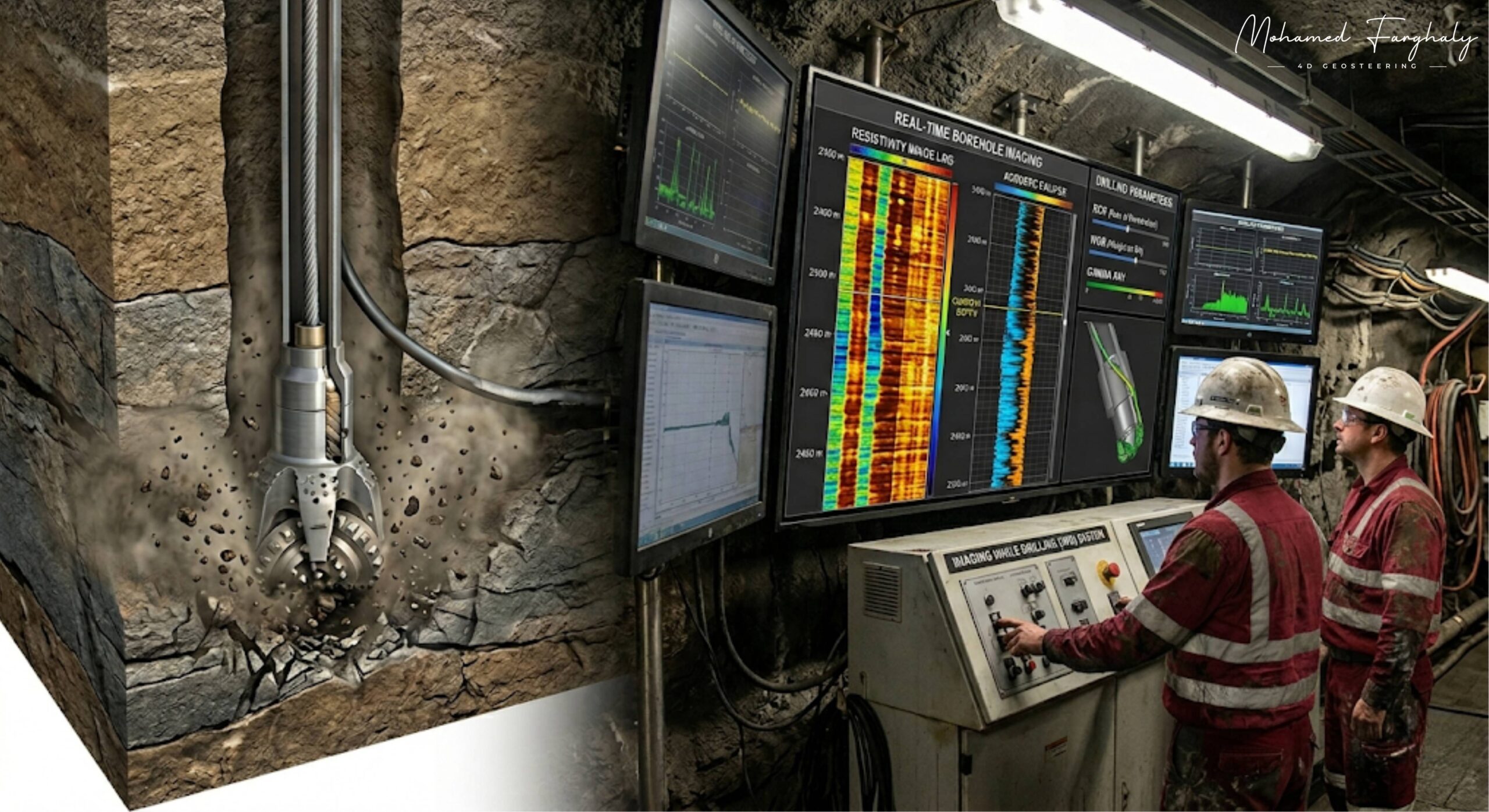
    Automated geosteering uses software algorithms to process large volumes of real-time data and generate steering recommendations automatically. These systems continuously compare incoming measurements against geological models and calculate the most likely reservoir position.

    Modern automation platforms can evaluate thousands of possible geological scenarios within seconds. Many systems incorporate machine learning, probabilistic inversion, and uncertainty analysis to improve prediction accuracy and support faster decision-making.

    The primary advantage of automation is speed. Automated systems can analyze data continuously without fatigue, enabling rapid responses to changing downhole conditions. They also provide greater consistency by applying the same methodology throughout the drilling operation.

    Despite these benefits, automated systems depend heavily on data quality, model accuracy, and algorithm assumptions. If the geological model is incorrect or the incoming data contains errors, automated recommendations may become unreliable.

    Key Differences Between Manual and Automated Geosteering

    Risk Management: Manual interpretation offers expert judgment, while automation reduces repetitive analysis and potential human error.

    Decision Speed: Automated systems provide near-instant recommendations, while manual workflows require interpretation time.

    Consistency: Automation delivers standardized results, whereas manual interpretation can vary between individuals.

    Geological Flexibility: Human experts often perform better when encountering unexpected geological conditions.

    Data Processing: Automated systems can handle significantly larger volumes of real-time data.


    🔗 Keywords

    Geosteering Automation, Automated Geosteering, Real-Time Geosteering, Machine Learning in Oil and Gas, LWD Data, Formation Evaluation, Well Placement, Geosteering Risks, Geosteering Limitations, Digital Oilfield, Drilling Automation, Reservoir Navigation.


  • Remote Operations Centers

    Jan 10, 2026 · 2 minutes reading

    What if geosteering decisions could be made by a full team of experts without being physically on the rig site? That is exactly what Remote Operations Centers bring to modern geosteering operations — a connected environment where real-time data meets collective expertise.

    In today’s drilling industry, Remote Operations Centers (ROCs) allow engineers, geologists, and geosteerers to monitor and control operations from a centralized location. For geosteering, this means continuous access to real-time LWD data, MWD measurements, and surface information, all analyzed by specialists working together.

    The strength of remote geosteering lies in collaboration and speed. Instead of relying on a limited on-site team, multiple experts can interpret data simultaneously, improving geosteering decisions and increasing overall geosteering accuracy. This leads to better well placement and more efficient drilling operations.

    In directional drilling, where geosteering requires constant monitoring and adjustment, Remote Operations Centers provide a major advantage. They enable faster response to formation changes, better communication between teams, and more consistent geosteering operations across multiple wells.

    When combined with advanced technologies such as artificial intelligence, machine learning, and digital twins, Remote Operations Centers become even more powerful for geosteering. These technologies enhance data interpretation, support predictive analysis, and improve real-time geosteering decisions.

    Another key benefit of remote geosteering operations is risk reduction. By centralizing expertise and improving data access, companies can reduce operational errors, enhance safety, and maintain better control over drilling performance.

    Many still think of geosteering as a rig-based activity, but Remote Operations Centers are changing that perspective. They allow geosteering to become more scalable, more collaborative, and more data-driven.

    If you want to understand how modern geosteering is evolving, start with Remote Operations Centers. They are redefining how data, expertise, and technology come together to deliver smarter geosteering decisions.


    🔗 Keywords

    Drilling Rig, Drilling Mud, MWD, LWD, Directional Drilling, Geosteering, Well Placement, Oil Reservoir, Surface Logging, Borehole Imaging, Electromagnetic Resistivity LWD Tool, Bottom Hole Assembly, Study of Real-Time LWD Data, LWD Interpretation, Borehole Image Log, Dip Calculation Methods, Shale Gas Sweet Spot, Accurate Reservoir Boundary Detection, Machine Learning, Artificial Intelligence, The Future of Automated Geosteering, Ensemble-Based Well Log Interpretation, Digital Twins in Drilling, Remote Operations Centers


  • Digital Twins in Drilling

    Jan 7, 2026 · 2 minutes reading

    Every geosteering decision carries risk — but what if you could see the outcome before making the move? That is exactly what digital twins in drilling bring to modern geosteering operations — a virtual environment where decisions can be tested before they are applied in real time.

    A digital twin is a real-time digital model of the well, continuously updated using data from LWD, MWD, and surface systems. In geosteering, this allows teams to simulate formation behavior, predict outcomes, and improve geosteering decisions before applying them in the field.

    The value of digital twins in geosteering lies in prediction and optimization. By combining real-time LWD data with advanced models, digital twins help improve well placement, reduce uncertainty, and enhance overall geosteering accuracy.

    In directional drilling, where geosteering requires constant adjustments, digital twins provide a powerful advantage. They allow geosteerers to visualize possible scenarios and choose the most effective trajectory for maintaining the well within the target zone.

    When integrated with artificial intelligence and machine learning, digital twins in geosteering become even more powerful. They continuously learn from new data, improving predictions and supporting faster, smarter geosteering decisions.

    Many see geosteering as a real-time process only, but digital twins extend it into a predictive one. They allow teams to move from reacting to conditions to anticipating them, making geosteering operations more efficient and reliable.

    If you want to understand the future of geosteering, start with digital twins in drilling. It is where simulation meets reality to create smarter geosteering decisions.


    🔗 Keywords

    Drilling Rig, Drilling Mud, MWD, LWD, Directional Drilling, Geosteering, Well Placement, Oil Reservoir, Surface Logging, Borehole Imaging, Electromagnetic Resistivity LWD Tool, Bottom Hole Assembly, Study of Real-Time LWD Data, LWD Interpretation, Borehole Image Log, Dip Calculation Methods, Shale Gas Sweet Spot, Accurate Reservoir Boundary Detection, Machine Learning, Artificial Intelligence, The Future of Automated Geosteering, Ensemble-Based Well Log Interpretation, Digital Twins in Drilling, Remote Operations Centers


  • Ensemble-Based Well Log Interpretation

    Jan 4, 2026 · 3 minutes reading

    Every geosteering decision carries uncertainty — but what if you could reduce that uncertainty by looking at the formation from multiple perspectives at the same time? That is exactly what ensemble-based well log interpretation brings to modern geosteering operations — a smarter, more reliable way to understand the subsurface.

    In traditional workflows, geosteering often relies on a single interpretation of well log data such as resistivity, gamma ray, density, and neutron porosity. However, subsurface conditions are inherently complex, and relying on one model can introduce significant uncertainty. Ensemble-based interpretation in geosteering addresses this challenge by combining multiple models to improve geosteering accuracy and decision reliability.

    In ensemble-based well log interpretation for geosteering, different models analyze the same real-time LWD data and generate multiple possible interpretations of the formation. These interpretations are then combined, compared, and weighted to produce a more robust understanding of the subsurface. This approach strengthens geosteering decisions by reducing the risk of relying on a single incorrect interpretation.

    This method becomes especially important in directional drilling and horizontal wells, where geosteering requires continuous adjustments to stay within a thin reservoir zone. Small errors in interpretation can lead to poor well placement, reduced reservoir contact, and lower production efficiency. By using ensemble methods, geosteerers gain a clearer and more reliable picture of formation boundaries and reservoir behavior.

    When integrated with Measurement While Drilling (MWD), ensemble-based interpretation becomes a core component of advanced geosteering workflows. MWD provides accurate trajectory data, while ensemble models improve the interpretation of formation responses. Together, they support precise and data-driven geosteering operations.

    One of the key strengths of ensemble-based geosteering is its ability to quantify uncertainty. Instead of providing a single answer, it presents a range of possible outcomes, allowing geosteerers to evaluate risks and make more informed decisions. This is critical in complex reservoirs, where uncertainty is unavoidable and must be managed effectively.

    In addition, ensemble-based well log interpretation enhances the ability to detect subtle formation changes. By comparing multiple interpretations, it becomes easier to identify trends, recognize inconsistencies, and improve confidence in identifying reservoir boundaries. This directly improves geosteering accuracy and supports better well placement decisions.

    As machine learning and artificial intelligence continue to evolve, ensemble-based geosteering is becoming more advanced and more efficient. These technologies allow models to learn from historical and real-time data, improving their predictions and enabling faster, more accurate geosteering decisions.

    Many professionals still rely on single-model interpretation, but the future of geosteering is clearly moving toward integrated, data-driven approaches. Ensemble-based interpretation represents a major step forward, providing stronger insights and more reliable outcomes in real-time drilling environments.

    If you want to improve geosteering accuracy, reduce uncertainty, and make more confident decisions, start with ensemble-based well log interpretation. It is where multiple perspectives come together to create smarter and more precise geosteering decisions.


    🔗 Keywords

    Drilling Rig, Drilling Mud, MWD, LWD, Directional Drilling, Geosteering, Well Placement, Oil Reservoir, Surface Logging, Borehole Imaging, Electromagnetic Resistivity LWD Tool, Bottom Hole Assembly, Study of Real-Time LWD Data, LWD Interpretation, Borehole Image Log, Dip Calculation Methods, Shale Gas Sweet Spot, Accurate Reservoir Boundary Detection, Machine Learning, Artificial Intelligence, The Future of Automated Geosteering, Ensemble-Based Well Log Interpretation, Digital Twins in Drilling, Remote Operations Centers


  • The Future of Automated Geosteering

    Dec 31, 2025 · 2 minutes reading

    What if geosteering could adjust the well path automatically, without waiting for manual decisions? That is exactly where the industry is heading — toward automated geosteering, where data, algorithms, and real-time systems work together to optimize every move.

    In modern drilling operations, geosteering already depends on continuous data from LWD, MWD, and surface systems. The future of automated geosteering takes this further by allowing systems to analyze data instantly and recommend or execute trajectory adjustments in real time.

    The core advantage of automated geosteering is speed and consistency. Instead of relying only on manual interpretation, automated systems process real-time LWD data and apply advanced models to improve geosteering accuracy and optimize well placement.

    In directional drilling and horizontal wells, where geosteering requires constant monitoring, automation can reduce delays and improve response time. This allows wells to stay within the most productive zones with higher precision and fewer human-driven errors.

    When combined with artificial intelligence and machine learning, automated geosteering becomes even more powerful. These technologies enable systems to learn from previous wells, recognize patterns, and continuously improve geosteering decisions over time.

    The future of geosteering is not about replacing geosteerers, but about enhancing their capabilities. Automated systems support faster interpretation, better predictions, and more reliable decision-making, making geosteering operations more efficient and consistent.

    Many still see geosteering as a fully manual process, but the shift toward automation is already happening. The integration of real-time data, AI, and automation is transforming how wells are drilled and how geosteering is performed.

    If you want to understand where geosteering is heading, look at automated geosteering. It is the next step in evolving geosteering operations into a fully data-driven, intelligent system.


    🔗 Keywords

    Drilling Rig, Drilling Mud, MWD, LWD, Directional Drilling, Geosteering, Well Placement, Oil Reservoir, Surface Logging, Borehole Imaging, Electromagnetic Resistivity LWD Tool, Bottom Hole Assembly, Study of Real-Time LWD Data, LWD Interpretation, Borehole Image Log, Dip Calculation Methods, Shale Gas Sweet Spot, Accurate Reservoir Boundary Detection, Machine Learning, Artificial Intelligence, The Future of Automated Geosteering, Ensemble-Based Well Log Interpretation, Digital Twins in Drilling, Remote Operations Centers


  • Artificial Intelligence in Geosteering

    Dec 20, 2025 · 2 minutes reading

    What if geosteering decisions could be faster, smarter, and more accurate without increasing operational pressure? That is exactly what artificial intelligence in geosteering is bringing to modern drilling — a new level of precision in real-time geosteering operations.

    In today’s drilling environment, geosteering depends on continuous analysis of data from LWD, MWD, and surface systems. Artificial intelligence (AI) enhances this process by analyzing large volumes of real-time and historical data, identifying patterns, and supporting better geosteering decisions.

    The strength of artificial intelligence in geosteering lies in its ability to process complex data faster than traditional methods. It helps detect formation changes, predict reservoir boundaries, and improve well placement by providing insights that support accurate and efficient geosteering.

    In directional drilling and horizontal wells, where geosteering requires constant adjustments, AI can assist by predicting the best trajectory and identifying optimal zones. This allows geosteerers to move from reactive to proactive geosteering strategies.

    When integrated with real-time LWD data and Measurement While Drilling (MWD), artificial intelligence strengthens the entire geosteering workflow. It combines trajectory data with formation evaluation to improve decision-making and enhance overall geosteering accuracy.

    One of the key advantages of AI in geosteering is reducing uncertainty. By learning from previous wells and continuously updating models, AI improves prediction quality and supports more confident geosteering decisions in complex reservoirs.

    Many still view geosteering as a purely manual process, but artificial intelligence is changing that perspective. It does not replace human expertise — it enhances it, allowing geosteerers to make faster and more informed decisions.

    If you want to understand where geosteering is heading, start with artificial intelligence. It is the bridge between data and smarter, more efficient geosteering operations.


    🔗 Keywords

    Drilling Rig, Drilling Mud, MWD, LWD, Directional Drilling, Geosteering, Well Placement, Oil Reservoir, Surface Logging, Borehole Imaging, Electromagnetic Resistivity LWD Tool, Bottom Hole Assembly, Study of Real-Time LWD Data, LWD Interpretation, Borehole Image Log, Dip Calculation Methods, Shale Gas Sweet Spot, Accurate Reservoir Boundary Detection, Machine Learning, Artificial Intelligence, The Future of Automated Geosteering, Ensemble-Based Well Log Interpretation, Digital Twins in Drilling, Remote Operations Centers


  • Machine Learning in Geosteering

    Nov 14, 2025 · 2 minutes reading

    What if geosteering decisions could improve automatically with every well drilled? That is exactly what machine learning in geosteering is starting to achieve — transforming large volumes of data into faster, smarter, and more accurate geosteering decisions.

    In modern drilling operations, geosteering generates massive amounts of data from LWD, MWD, and surface measurements. Machine learning uses this data to identify patterns, predict formation behavior, and support real-time geosteering interpretation. Instead of relying only on manual analysis, geosteerers can now enhance their decisions using data-driven insights.

    The real value of machine learning in geosteering lies in its ability to recognize trends that may not be obvious to the human eye. By analyzing historical and real-time data, machine learning models can improve well placement, optimize trajectory adjustments, and increase overall geosteering accuracy.

    In directional drilling and horizontal wells, where geosteering requires continuous decision-making, machine learning can assist by predicting formation boundaries and identifying sweet spots. This allows for more proactive geosteering operations rather than reactive adjustments.

    When integrated with real-time LWD data and Measurement While Drilling (MWD), machine learning becomes a powerful tool for enhancing geosteering workflows. It combines trajectory data with formation evaluation to provide recommendations that support precise and efficient geosteering decisions.

    One of the key advantages of machine learning in geosteering is its ability to reduce uncertainty. By continuously learning from new data, it improves prediction accuracy over time, helping geosteerers make better decisions under complex geological conditions.

    Many still see geosteering as a fully manual process, but the integration of machine learning is changing that perspective. It does not replace the geosteerer — it strengthens decision-making by adding a powerful layer of data analysis.

    If you want to understand the future of geosteering, start with machine learning. It is where data becomes intelligence, and intelligence drives more accurate and efficient geosteering decisions.


    🔗 Keywords

    Drilling Rig, Drilling Mud, MWD, LWD, Directional Drilling, Geosteering, Well Placement, Oil Reservoir, Surface Logging, Borehole Imaging, Electromagnetic Resistivity LWD Tool, Bottom Hole Assembly, Study of Real-Time LWD Data, LWD Interpretation, Borehole Image Log, Dip Calculation Methods, Shale Gas Sweet Spot, Accurate Reservoir Boundary Detection, Machine Learning, Artificial Intelligence, The Future of Automated Geosteering, Ensemble-Based Well Log Interpretation, Digital Twins in Drilling, Remote Operations Centers


  • Method for Accurate Reservoir Boundary Detection

    November 7, 2025 · 2 minutes reading

    What if the difference between a successful well and a poor one is simply how early you detect a boundary? In geosteering, this is exactly what defines performance — and that is why accurate reservoir boundary detection is one of the most critical skills in modern drilling.

    In geosteering operations, reservoir boundaries are not just geological lines — they are real-time decision points. Detecting the top and base of the reservoir early allows geosteerers to adjust the well trajectory and maintain optimal well placement inside the target zone.

    The main methods for reservoir boundary detection in geosteering rely heavily on real-time LWD data. Changes in gamma ray, resistivity, and density logs help identify lithology transitions that signal approaching boundaries. These subtle changes are the foundation of accurate geosteering interpretation.

    In directional drilling and horizontal wells, boundary detection becomes even more important. A slight delay in recognizing a formation change can push the well outside the reservoir, reducing production efficiency. This is why continuous monitoring is essential in geosteering workflows.

    When combined with Measurement While Drilling (MWD), boundary detection becomes more powerful. MWD provides the well trajectory, while LWD responses define formation changes. Together, they form the backbone of accurate geosteering decisions and controlled well placement.

    Advanced geosteering methods also include pattern recognition, offset well correlation, and integration with borehole image logs to improve confidence in identifying reservoir limits. These techniques reduce uncertainty and improve real-time geosteering accuracy.

    Many underestimate the importance of boundary detection in geosteering, focusing only on staying inside the reservoir. However, true success in geosteering depends on knowing exactly where the boundaries are and reacting before the well crosses them.

    If you want to improve geosteering performance and achieve precise well placement, mastering reservoir boundary detection methods is essential. It is one of the most important foundations of successful geosteering operations.


    🔗 Keywords

    Drilling Rig, Drilling Mud, MWD, LWD, Directional Drilling, Geosteering, Well Placement, Oil Reservoir, Surface Logging, Borehole Imaging, Electromagnetic Resistivity LWD Tool, Bottom Hole Assembly, Study of Real-Time LWD Data, LWD Interpretation, Borehole Image Log, Dip Calculation Methods, Shale Gas Sweet Spot, Accurate Reservoir Boundary Detection, Machine Learning, Artificial Intelligence, The Future of Automated Geosteering, Ensemble-Based Well Log Interpretation, Digital Twins in Drilling, Remote Operations Centers


  • Shale Gas Sweet Spot Identification

    September 13, 2025 · 2 minutes reading

    What if the success of geosteering is not just about staying in the reservoir, but about staying in the best part of it? That is exactly what shale gas sweet spot identification is about — finding the zones where geosteering delivers maximum production value.

    In shale reservoirs, not all zones are equal. Some intervals have better porosity, higher organic content, and improved permeability. Identifying these zones is essential for effective geosteering, as it ensures the well is placed in the most productive interval rather than just anywhere within the formation.

    Shale gas sweet spot identification in geosteering relies heavily on real-time LWD data. Measurements such as gamma ray, resistivity, and density help geosteerers evaluate formation quality and detect subtle variations that indicate high-potential zones. This allows for more accurate geosteering decisions and improved well placement.

    In directional drilling and horizontal wells, geosteering plays a critical role in maintaining the well within these sweet spots. Even small deviations can move the well away from the optimal zone, reducing production efficiency. Continuous monitoring and adjustment are key to successful geosteering operations.

    When combined with Measurement While Drilling (MWD), shale gas sweet spot identification becomes a fully integrated part of geosteering. MWD defines the trajectory, while LWD data helps identify where the best zones are located. Together, they enable precise and optimized geosteering decisions.

    Effective geosteering in shale formations also requires understanding natural fractures and stress distribution. These factors influence both production performance and drilling behavior, making them critical for accurate sweet spot identification and improved well placement.

    Many focus only on reaching the reservoir, but in reality, the success of geosteering depends on targeting the right part of the reservoir. Identifying and staying within the sweet spot is what transforms a good well into a highly productive one.

    If you want to improve your geosteering performance and maximize production, start with shale gas sweet spot identification. It is the key to turning reservoir presence into real production results through precise geosteering decisions.


    🔗 Keywords

    Drilling Rig, Drilling Mud, MWD, LWD, Directional Drilling, Geosteering, Well Placement, Oil Reservoir, Surface Logging, Borehole Imaging, Electromagnetic Resistivity LWD Tool, Bottom Hole Assembly, Study of Real-Time LWD Data, LWD Interpretation, Borehole Image Log, Dip Calculation Methods, Shale Gas Sweet Spot, Accurate Reservoir Boundary Detection, Machine Learning, Artificial Intelligence, The Future of Automated Geosteering, Ensemble-Based Well Log Interpretation, Digital Twins in Drilling, Remote Operations Centers


  • Dip Calculation Methods

    August 9, 2025 · 3 minutes reading

    What if one small miscalculation in formation dip could shift your entire geosteering decision? That is exactly why understanding dip calculation methods is critical for achieving accurate and reliable geosteering operations.

    In modern drilling, dip calculation is a key part of geosteering because it defines how geological layers are oriented in the subsurface. By determining dip angle and dip direction, geosteerers can understand how the formation is positioned relative to the wellbore and make better geosteering decisions.

    Dip calculation methods in geosteering rely on multiple data sources, including Logging While Drilling (LWD) measurements, resistivity responses, and borehole image data. These inputs are analyzed to estimate formation boundaries and predict how the reservoir extends ahead of the bit. Accurate dip estimation is essential for maintaining optimal well placement.

    In directional drilling and horizontal wells, the importance of dip increases significantly. Even a small error in dip interpretation can cause incorrect geosteering adjustments, leading the well away from the target zone. This is why continuous refinement of dip calculations is required throughout the geosteering process.

    When combined with Measurement While Drilling (MWD), dip calculation methods become even more powerful for geosteering. MWD provides the well trajectory, while dip calculations define the orientation of the formation. Together, they allow geosteerers to align the well path with the reservoir structure and improve geosteering accuracy.

    Advanced geosteering workflows use multiple dip estimation techniques, including structural correlation, real-time log interpretation, and image-based analysis. These methods help reduce uncertainty and improve confidence in geosteering decisions, especially in complex geological environments.

    Many underestimate the importance of dip in geosteering, focusing only on staying within the reservoir. However, true geosteering precision comes from understanding how the reservoir is oriented and how the well should move relative to it.

    If you want to improve your geosteering skills and achieve better well placement, start with mastering dip calculation methods. It is the key to aligning the well with the structure and making accurate geosteering decisions.


    🔗 Keywords

    Drilling Rig, Drilling Mud, MWD, LWD, Directional Drilling, Geosteering, Well Placement, Oil Reservoir, Surface Logging, Borehole Imaging, Electromagnetic Resistivity LWD Tool, Bottom Hole Assembly, Study of Real-Time LWD Data, LWD Interpretation, Borehole Image Log, Dip Calculation Methods, Shale Gas Sweet Spot, Accurate Reservoir Boundary Detection, Machine Learning, Artificial Intelligence, The Future of Automated Geosteering, Ensemble-Based Well Log Interpretation, Digital Twins in Drilling, Remote Operations Centers


  • Study of Real-Time LWD Data

    July 1, 2025 · 2 minutes reading

    What if every geosteering decision you make could be based on live data coming directly from the formation? That is exactly what the study of real-time LWD data enables — and it is one of the most critical elements behind successful geosteering operations.

    In modern drilling, real-time LWD data is the foundation of effective geosteering. It provides continuous measurements such as resistivity, density, neutron porosity, and gamma ray, allowing geologists and engineers to evaluate the formation while drilling is still in progress. Without this data, accurate geosteering would not be possible.

    The real value of LWD data in geosteering lies in interpretation. Data alone does not guide the well — understanding it does. By analyzing trends, detecting formation changes, and identifying reservoir boundaries, geosteerers can make precise decisions that directly impact well placement and overall drilling success.

    This becomes even more critical in directional drilling and horizontal wells, where geosteering is required to keep the well within a thin reservoir zone. Continuous interpretation of Logging While Drilling (LWD) data allows for immediate trajectory adjustments, ensuring the well remains within the most productive interval.

    When combined with Measurement While Drilling (MWD), geosteering becomes a fully integrated process. MWD provides the well path, while LWD provides formation insight. Together, they enable real-time geosteering decisions that optimize reservoir contact and improve production potential.

    The study of real-time LWD data also strengthens geosteering accuracy by reducing uncertainty. It helps detect fluid contacts, formation tops, and subtle changes in lithology, allowing geosteerers to react before the well exits the target zone. This is essential for maintaining control during complex geosteering operations.

    Many underestimate the importance of interpretation in geosteering, focusing only on the tools. But in reality, the ability to study and understand LWD data is what transforms geosteering from a reactive process into a proactive, data-driven strategy.

    If you want to master geosteering and understand how wells are placed with precision, start with the study of real-time LWD data. It is where measurements become insight, and insight becomes accurate geosteering decisions.


    🔗 Keywords

    Drilling Rig, Drilling Mud, MWD, LWD, Directional Drilling, Geosteering, Well Placement, Oil Reservoir, Surface Logging, Borehole Imaging, Electromagnetic Resistivity LWD Tool, Bottom Hole Assembly, Study of Real-Time LWD Data, LWD Interpretation, Borehole Image Log, Dip Calculation Methods, Shale Gas Sweet Spot, Accurate Reservoir Boundary Detection, Machine Learning, Artificial Intelligence, The Future of Automated Geosteering, Ensemble-Based Well Log Interpretation, Digital Twins in Drilling, Remote Operations Centers


  • Borehole Image Log Technology

    June 11, 2025 · 2 minutes reading

    What if geosteering was not only based on data, but also on actual images of the formation? That is exactly what Borehole Image Log Technology brings to modern geosteering operations — the ability to visualize the subsurface and make more accurate geosteering decisions.

    In advanced drilling operations, borehole image logs provide high-resolution images of the wellbore wall. These images reveal critical geological features such as bedding planes, fractures, faults, and formation textures. In geosteering, this visual information adds a deeper level of understanding that goes beyond standard log measurements.

    Unlike conventional Logging While Drilling (LWD) data, which provides indirect measurements, borehole image log technology offers structural insight. This is essential for geosteering, where understanding formation dip, direction, and orientation directly impacts well placement and trajectory control.

    The role of borehole imaging in geosteering becomes even more important in complex reservoirs. In thin beds or highly fractured formations, small structural variations can significantly affect geosteering accuracy. By using borehole images, geosteerers can detect these variations early and adjust the well path accordingly.

    When integrated with Measurement While Drilling (MWD) and LWD, borehole image log technology strengthens the entire geosteering workflow. MWD provides the well trajectory, LWD provides formation properties, and borehole imaging adds structural clarity. Together, they enable precise and confident geosteering decisions.

    One of the key advantages of borehole image logs in geosteering is the ability to identify natural fractures and stress patterns. These features influence both drilling performance and reservoir productivity, making them essential for optimizing well placement and improving long-term results.

    Many overlook the importance of visual data in geosteering, focusing only on numerical logs. However, borehole image log technology transforms interpretation by turning data into a visual representation of the subsurface, improving both accuracy and confidence in geosteering operations.

    If you want to take geosteering to a higher level of precision, start with Borehole Image Log Technology. It is where data becomes visualization, and visualization leads to smarter geosteering decisions.


    🔗 Keywords

    Drilling Rig, Drilling Mud, MWD, LWD, Directional Drilling, Geosteering, Well Placement, Oil Reservoir, Surface Logging, Borehole Imaging, Electromagnetic Resistivity LWD Tool, Bottom Hole Assembly, Study of Real-Time LWD Data, LWD Interpretation, Borehole Image Log, Dip Calculation Methods, Shale Gas Sweet Spot, Accurate Reservoir Boundary Detection, Machine Learning, Artificial Intelligence, The Future of Automated Geosteering, Ensemble-Based Well Log Interpretation, Digital Twins in Drilling, Remote Operations Centers


  • Bottom Hole Assembly

    June 10, 2025 · 1 minute reading

    Geosteering is not only about data and interpretation — it is about how those decisions are physically executed downhole. The Bottom Hole Assembly (BHA) is the system that turns geosteering decisions into real wellbore movement.

    The BHA is located just above the drill bit and includes key components such as stabilizers, drill collars, and advanced tools like MWD (Measurement While Drilling) and LWD (Logging While Drilling). Together, they provide the data and mechanical control needed for effective geosteering.

    In Directional Drilling, the BHA directly controls the well trajectory. Its design determines whether the well builds angle, holds direction, or changes course — making it essential for precise geosteering and accurate Well Placement within the Oil Reservoir.

    The integration of MWD and LWD within the BHA enables continuous Study of Real-Time LWD Data and supports fast geosteering adjustments. This ensures the well stays within the target zone and reduces uncertainty during drilling.

    In simple terms, the Bottom Hole Assembly is the execution engine of geosteering, converting real-time data into precise and controlled wellbore navigation.


    🔗 Keywords

    Drilling Rig, Drilling Mud, MWD, LWD, Directional Drilling, Geosteering, Well Placement, Oil Reservoir, Surface Logging, Borehole Imaging, Electromagnetic Resistivity LWD Tool, Bottom Hole Assembly, Study of Real-Time LWD Data, LWD Interpretation, Borehole Image Log, Dip Calculation Methods, Shale Gas Sweet Spot, Accurate Reservoir Boundary Detection, Machine Learning, Artificial Intelligence, The Future of Automated Geosteering, Ensemble-Based Well Log Interpretation, Digital Twins in Drilling, Remote Operations Centers


  • Electromagnetic Resistivity LWD Tool

    June 5 , 2025· 2 minutes reading

    One of the biggest challenges in geosteering is knowing whether the well is staying inside the target reservoir in real time. The Electromagnetic Resistivity LWD Tool is a key technology that solves this challenge and makes modern geosteering far more accurate and reliable.

    This tool works by sending electromagnetic signals into the formation and measuring how strongly the rocks resist electrical current. Different fluids respond differently — hydrocarbons, water, and shale each produce unique resistivity signatures. This allows engineers to interpret formation properties instantly and make better geosteering decisions.

    Unlike traditional wireline logging, the resistivity Logging While Drilling (LWD) tool operates continuously during drilling. This is essential for real-time geosteering, especially in Directional Drilling and horizontal wells where staying inside the Oil Reservoir is critical for optimal Well Placement.

    The real strength of this tool appears in complex reservoirs, where geosteering requires early detection of formation boundaries and fluid contacts such as oil-water or gas-water transitions. These insights allow geosteering teams to adjust the well path and maintain maximum reservoir exposure.

    When combined with Measurement While Drilling (MWD), the resistivity tool becomes a core part of the geosteering system. MWD provides trajectory data, while resistivity LWD reveals formation properties. Together, they enable precise, data-driven geosteering and reduce uncertainty during drilling.

    Advanced resistivity tools can even detect boundaries ahead of or around the wellbore, supporting Accurate Reservoir Boundary Detection. This gives geosteering teams the ability to react before exiting the target zone, improving efficiency and minimizing risk.

    In addition, continuous Study of Real-Time LWD Data and advanced LWD Interpretation techniques further enhance geosteering accuracy. Modern approaches using Machine Learning and Artificial Intelligence are also being applied to optimize interpretation and support the Future of Automated Geosteering.

    In simple terms, the Electromagnetic Resistivity LWD Tool is not just a measurement device — it is a core driver of modern geosteering, transforming subsurface physics into real-time insight and enabling precise reservoir navigation.


    🔗 Keywords

    Drilling Rig, Drilling Mud, MWD, LWD, Directional Drilling, Geosteering, Well Placement, Oil Reservoir, Surface Logging, Borehole Imaging, Electromagnetic Resistivity LWD Tool, Bottom Hole Assembly, Study of Real-Time LWD Data, LWD Interpretation, Borehole Image Log, Dip Calculation Methods, Shale Gas Sweet Spot, Accurate Reservoir Boundary Detection, Machine Learning, Artificial Intelligence, The Future of Automated Geosteering, Ensemble-Based Well Log Interpretation, Digital Twins in Drilling, Remote Operations Centers


  • Surface Logging

    April 2, 2025· 3 minutes reading

    Successful geosteering is not only driven by downhole tools — it also depends on what can be observed and analyzed at the surface. Surface Logging plays a critical role in modern geosteering by providing continuous, real-time insight into subsurface conditions.

    Surface logging, often carried out by mud loggers, is the process of analyzing drilling returns to understand subsurface conditions. In geosteering operations, it transforms cuttings, gas readings, and drilling parameters into real-time data that helps guide decisions and improve Well Placement within the Oil Reservoir.

    As the drill bit cuts through formations, rock fragments are transported to the surface by Drilling Mud. These cuttings are analyzed to identify lithology changes and potential reservoir zones, which directly support geosteering decisions. At the same time, gas monitoring provides early indications of hydrocarbons and pressure variations, both critical for effective geosteering.

    What makes surface logging powerful is its role in real-time decision-making. It provides early warning signs of formation changes, drilling hazards, and reservoir entry — all of which are essential for accurate geosteering and safe operations.

    Unlike downhole tools such as MWD (Measurement While Drilling) and LWD (Logging While Drilling), surface logging works from the surface but still plays a major role in geosteering. It acts as a validation layer, confirming data from downhole measurements and improving confidence in geosteering interpretations.

    Surface logging also supports Study of Real-Time LWD Data and enhances LWD Interpretation by providing additional geological context. This integration strengthens the overall geosteering workflow and reduces uncertainty during drilling.

    In many cases, surface logging becomes the first indicator of changes in formation pressure, fluid content, or lithology. Even small variations in gas or cuttings can significantly influence geosteering strategy and help prevent costly mistakes.

    Today, advanced technologies such as Machine Learning and Artificial Intelligence are being applied to surface logging data to improve pattern recognition and enhance geosteering accuracy. These innovations are contributing to the Future of Automated Geosteering, where decisions are faster and more data-driven.

    In simple terms, surface logging is not just a support system — it is a critical part of modern geosteering, turning surface data into actionable subsurface insight and helping ensure precise and efficient drilling.


    🔗 Keywords

    Drilling Rig, Drilling Mud, MWD, LWD, Directional Drilling, Geosteering, Well Placement, Oil Reservoir, Surface Logging, Borehole Imaging, Electromagnetic Resistivity LWD Tool, Bottom Hole Assembly, Study of Real-Time LWD Data, LWD Interpretation, Borehole Image Log, Dip Calculation Methods, Shale Gas Sweet Spot, Accurate Reservoir Boundary Detection, Machine Learning, Artificial Intelligence, The Future of Automated Geosteering, Ensemble-Based Well Log Interpretation, Digital Twins in Drilling, Remote Operations Centers


  • LWD Interpretation

    March 5, 2025 · 2 minutes reading

    What if the success of geosteering depends not on the tools themselves, but on how well you interpret the data? That is exactly what LWD interpretation represents — the foundation of precise and effective geosteering decisions.

    In modern drilling operations, Logging While Drilling (LWD) provides continuous real-time data from the formation. However, in geosteering, the true value lies in how this data is interpreted. Without accurate LWD interpretation, even the most advanced tools cannot deliver reliable geosteering results.

    LWD interpretation in geosteering involves analyzing measurements such as resistivity, gamma ray, density, and neutron porosity to understand lithology, fluid distribution, and formation boundaries. These insights are essential for maintaining accurate geosteering and ensuring optimal well placement.

    This becomes even more critical in directional drilling and horizontal wells, where geosteering requires continuous monitoring and adjustment. A small error in LWD interpretation can lead to incorrect geosteering decisions, causing the well to move away from the most productive zone.

    When combined with Measurement While Drilling (MWD), LWD interpretation becomes the driving force behind real-time geosteering operations. MWD provides the trajectory, while LWD interpretation provides the geological understanding needed for accurate geosteering. Together, they enable consistent and controlled geosteering decisions.

    The strength of geosteering relies heavily on the quality of LWD interpretation. By identifying subtle formation changes, detecting fluid contacts, and recognizing reservoir boundaries early, geosteerers can improve geosteering accuracy and maintain control of the well path.

    Many focus on tools and technology, but in reality, geosteering success depends on interpretation skills. The ability to understand and act on real-time LWD data is what transforms geosteering into a proactive, data-driven process.

    If you want to master geosteering and improve well placement precision, start with LWD interpretation. It is where data becomes insight and insight becomes accurate geosteering decisions.


    🔗 Keywords

    Drilling Rig, Drilling Mud, MWD, LWD, Directional Drilling, Geosteering, Well Placement, Oil Reservoir, Surface Logging, Borehole Imaging, Electromagnetic Resistivity LWD Tool, Bottom Hole Assembly, Study of Real-Time LWD Data, LWD Interpretation, Borehole Image Log, Dip Calculation Methods, Shale Gas Sweet Spot, Accurate Reservoir Boundary Detection, Machine Learning, Artificial Intelligence, The Future of Automated Geosteering, Ensemble-Based Well Log Interpretation, Digital Twins in Drilling, Remote Operations Centers


  • Borehole Imaging

    Feb 14, 2025· 2 minutes reading

    Accurate geosteering is not only about tracking the well path — it is about understanding the structure of the formation in real time. That’s where Borehole Imaging plays a key role, enhancing geosteering by providing a clear structural view of the subsurface.

    In drilling and geosteering operations, borehole imaging tools generate high-resolution images of the wellbore wall. These images reveal important geological features such as bedding planes, fractures, and faults, all of which directly impact geosteering decisions and Well Placement within the Oil Reservoir.

    Unlike standard Logging While Drilling (LWD) measurements, which provide indirect data like resistivity or gamma ray, borehole imaging adds a structural perspective to geosteering. It helps determine dip angle, dip direction, and formation orientation — key inputs for accurate trajectory control during geosteering.

    This becomes especially important in complex reservoirs, where geosteering must navigate thin beds or fractured zones. Small structural changes can affect well performance, and borehole imaging helps detect them early, allowing real-time geosteering adjustments.

    When integrated with Measurement While Drilling (MWD) and LWD, borehole imaging strengthens the entire geosteering workflow. MWD defines the well path, LWD evaluates the formation, and imaging explains the structure — enabling more confident geosteering decisions.

    Advanced techniques like Dip Calculation Methods further improve interpretation, while modern tools powered by Machine Learning and Artificial Intelligence are enhancing data analysis and supporting the future of automated geosteering.

    In simple terms, borehole imaging is a key enabler of modern geosteering, turning subsurface data into clear structural insight and helping achieve more accurate and efficient drilling.

    If you want to understand how geosteering, structural geology, and well placement optimization come together, start with borehole imaging. It’s the closest thing to seeing the reservoir with your own eyes.


    🔗 Keywords

    Drilling Rig, Drilling Mud, MWD, LWD, Directional Drilling, Geosteering, Well Placement, Oil Reservoir, Surface Logging, Borehole Imaging, Electromagnetic Resistivity LWD Tool, Bottom Hole Assembly, Study of Real-Time LWD Data, LWD Interpretation, Borehole Image Log, Dip Calculation Methods, Shale Gas Sweet Spot, Accurate Reservoir Boundary Detection, Machine Learning, Artificial Intelligence, The Future of Automated Geosteering, Ensemble-Based Well Log Interpretation, Digital Twins in Drilling, Remote Operations Centers


  • Logging While Drilling (LWD)

    Jan 20, 2025 · 3 minutes reading

    What if the well could “describe” the rocks it is passing through in real time? That’s exactly what LWD makes possible. Logging-While-Drilling (LWD) is one of the most powerful technologies in modern drilling, giving engineers real-time insights into formation properties while the Drilling Rig is still in operation.

    Unlike traditional wireline logging, which is performed after drilling, LWD collects data while the drill bit is actively penetrating the formation. This means decisions are made in real time, not hours or days later. The tools are placed inside the Bottom Hole Assembly, very close to the bit, ensuring that measurements reflect the freshest and most accurate formation response.

    The main goal of LWD is formation evaluation during drilling. It measures key properties such as resistivity, density, porosity, and gamma ray response. These measurements help identify lithology changes, fluid content, and potential hydrocarbon zones within the Oil Reservoir. When combined with MWD, it also supports precise Directional Drilling and improves Well Placement decisions.

    One of the most critical applications of LWD is in Geosteering. As the well is drilled horizontally or directionally, real-time data allows engineers to adjust the trajectory to stay within the most productive zones. This continuous feedback loop is essential for avoiding unwanted formations like water-bearing zones or shale barriers, and for targeting high-quality intervals such as a Shale Gas Sweet Spot.

    Advanced LWD tools go beyond basic measurements. The Electromagnetic Resistivity LWD Tool provides deep reading of formation boundaries, helping detect fluid contacts and supporting Accurate Reservoir Boundary Detection. Meanwhile, Borehole Imaging and Borehole Image Log tools reveal structural details such as fractures, bedding planes, and stress orientation. These insights are further refined using Dip Calculation Methods, improving understanding of reservoir geometry.

    The true power of LWD lies in how it transforms raw data into actionable insight. Through LWD Interpretation and the Study of Real-Time LWD Data, geoscientists and drilling engineers can instantly react to changing conditions underground. This reduces uncertainty and increases drilling efficiency.

    When integrated with Surface Logging, MWD, and advanced analytics like Machine Learning and Artificial Intelligence, LWD becomes part of a larger intelligent drilling ecosystem. Data is often transmitted to Remote Operations Centers, where experts monitor and optimize decisions in real time, pushing the industry toward The Future of Automated Geosteering.

    In the end, LWD is not just about measuring formations—it is about seeing the reservoir while drilling and turning that vision into smarter, safer, and more productive wells.


    🔗 Keywords

    Drilling Rig, Drilling Mud, MWD, LWD, Directional Drilling, Geosteering, Well Placement, Oil Reservoir, Surface Logging, Borehole Imaging, Electromagnetic Resistivity LWD Tool, Bottom Hole Assembly, Study of Real-Time LWD Data, LWD Interpretation, Borehole Image Log, Dip Calculation Methods, Shale Gas Sweet Spot, Accurate Reservoir Boundary Detection, Machine Learning, Artificial Intelligence, The Future of Automated Geosteering, Ensemble-Based Well Log Interpretation, Digital Twins in Drilling, Remote Operations Centers


  • Gamma Ray Sensors: Reading the Earth’s Natural Fingerprints

    Nov 13, 2024 · 2 minutes reading

    Every rock underground carries a kind of natural signature—an invisible fingerprint formed over millions of years. In the oil and gas industry, one of the simplest yet most powerful tools for decoding this signature is the Gamma Ray Sensor, a key component of modern Logging While Drilling (LWD) systems.

    Gamma Ray measurements are based on detecting natural radioactivity emitted by formations, mainly from potassium, uranium, and thorium. Different rock types emit different levels of radiation, which allows engineers to distinguish between lithologies while drilling. Shales typically show high gamma ray values, while cleaner formations like sandstones and carbonates show much lower readings. This contrast is essential for identifying formation boundaries in real time.

    Placed within the Bottom Hole Assembly, Gamma Ray Sensors continuously collect data as the Drilling Rig penetrates deeper into the subsurface. This real-time measurement plays a major role in Directional Drilling and Well Placement, helping engineers understand exactly which formation the bit is currently drilling through.

    One of the most important applications of gamma ray data is in Geosteering. As the well is drilled horizontally, even small changes in gamma ray readings can indicate that the well is moving closer to or away from the target zone within the Oil Reservoir. This allows drilling teams to make immediate adjustments and stay within the most productive interval, avoiding unwanted shale barriers or water-bearing zones.

    When combined with other LWD measurements, gamma ray data becomes even more powerful. It supports LWD Interpretation by helping correlate lithology changes with resistivity and density readings. It is also widely used in the Study of Real-Time LWD Data, where continuous monitoring helps detect formation shifts and refine the geological model while drilling is in progress.

    In complex reservoirs, gamma ray trends are often used alongside Borehole Imaging and Borehole Image Log data to improve structural understanding. This integration helps identify subtle changes in stratigraphy and supports Accurate Reservoir Boundary Detection. In some cases, it also contributes to identifying sweet spots, including a Shale Gas Sweet Spot, where organic-rich formations show distinct gamma signatures.

    Modern workflows often integrate gamma ray data with MWD, Surface Logging, and advanced analytics such as Machine Learning and Artificial Intelligence. These technologies enhance pattern recognition and improve interpretation speed. In Remote Operations Centers, experts use this data to guide real-time decisions, moving the industry closer to The Future of Automated Geosteering.

    In the end, Gamma Ray Sensors are more than just measurement tools—they are the earth’s natural language translators. By reading these subtle signals, engineers can understand the subsurface with greater clarity and drill with far more confidence.


    🔗 Keywords

    Drilling Rig, Drilling Mud, MWD, LWD, Directional Drilling, Geosteering, Well Placement, Oil Reservoir, Surface Logging, Borehole Imaging, Electromagnetic Resistivity LWD Tool, Bottom Hole Assembly, Study of Real-Time LWD Data, LWD Interpretation, Borehole Image Log, Dip Calculation Methods, Shale Gas Sweet Spot, Accurate Reservoir Boundary Detection, Machine Learning, Artificial Intelligence, The Future of Automated Geosteering, Ensemble-Based Well Log Interpretation, Digital Twins in Drilling, Remote Operations Centers


  • Measurement While Drilling (MWD)

    Nov 4, 2024 · 2 minutes reading

    Deep beneath the surface, where direct observation is impossible, every drilling decision depends on one thing—reliable data. This is where MWD becomes essential. Short for Measurement-While-Drilling, MWD provides real-time information about the well’s position and drilling conditions, turning uncertainty into informed action during operations.

    At its core, MWD is designed to track the trajectory of the wellbore. By measuring parameters such as inclination, ազimuth, and toolface orientation, it ensures that Directional Drilling stays on the planned path. These measurements are critical for achieving accurate Well Placement, especially in complex reservoirs where even small deviations can lead to missing the target zone.

    The MWD system is typically integrated into the Bottom Hole Assembly, close to the drill bit. It uses sensors to collect data and transmits it to the surface through mud pulse telemetry, where pressure signals travel via the circulating Drilling Mud. This continuous data flow allows engineers to monitor drilling performance and make adjustments in real time, rather than waiting until after the well is drilled.

    While MWD focuses on wellbore positioning and drilling dynamics, it works closely with LWD, which provides formation evaluation data. Together, they form the backbone of modern Geosteering operations. By combining trajectory data from MWD with formation insights from LWD, teams can guide the well through the most productive parts of the Oil Reservoir with precision.

    In addition to directional control, MWD also measures key drilling parameters such as weight on bit, temperature, and vibration. These measurements help optimize drilling efficiency, reduce equipment wear, and prevent potential failures. When integrated with Surface Logging, operators gain a more complete picture of both downhole and surface conditions.

    The value of MWD extends even further when combined with advanced technologies. The Study of Real-Time LWD Data, supported by Machine Learning and Artificial Intelligence, allows for faster and more accurate decision-making. In many operations, data is transmitted to Remote Operations Centers, where experts analyze trends and provide guidance. This integration is a key step toward The Future of Automated Geosteering, where systems can respond to data with minimal human intervention.

    In today’s drilling environment, MWD is not just a tool—it is a necessity. It provides the directional awareness and real-time insight needed to drill smarter, safer, and more efficiently. Without it, precision drilling would simply not be possible.


    🔗 Keywords

    Drilling Rig, Drilling Mud, MWD, LWD, Directional Drilling, Geosteering, Well Placement, Oil Reservoir, Surface Logging, Borehole Imaging, Electromagnetic Resistivity LWD Tool, Bottom Hole Assembly, Study of Real-Time LWD Data, LWD Interpretation, Borehole Image Log, Dip Calculation Methods, Shale Gas Sweet Spot, Accurate Reservoir Boundary Detection, Machine Learning, Artificial Intelligence, The Future of Automated Geosteering, Ensemble-Based Well Log Interpretation, Digital Twins in Drilling, Remote Operations Centers