• Directional Drilling

    October 20, 2024 · 3 minutes reading

    I once heard someone describe Directional Drilling as “just changing the direction of the well,” but that never felt accurate. The reality is far more complex. A better way to understand it is like threading a needle—except the needle is thousands of meters underground, constantly moving, and completely invisible.

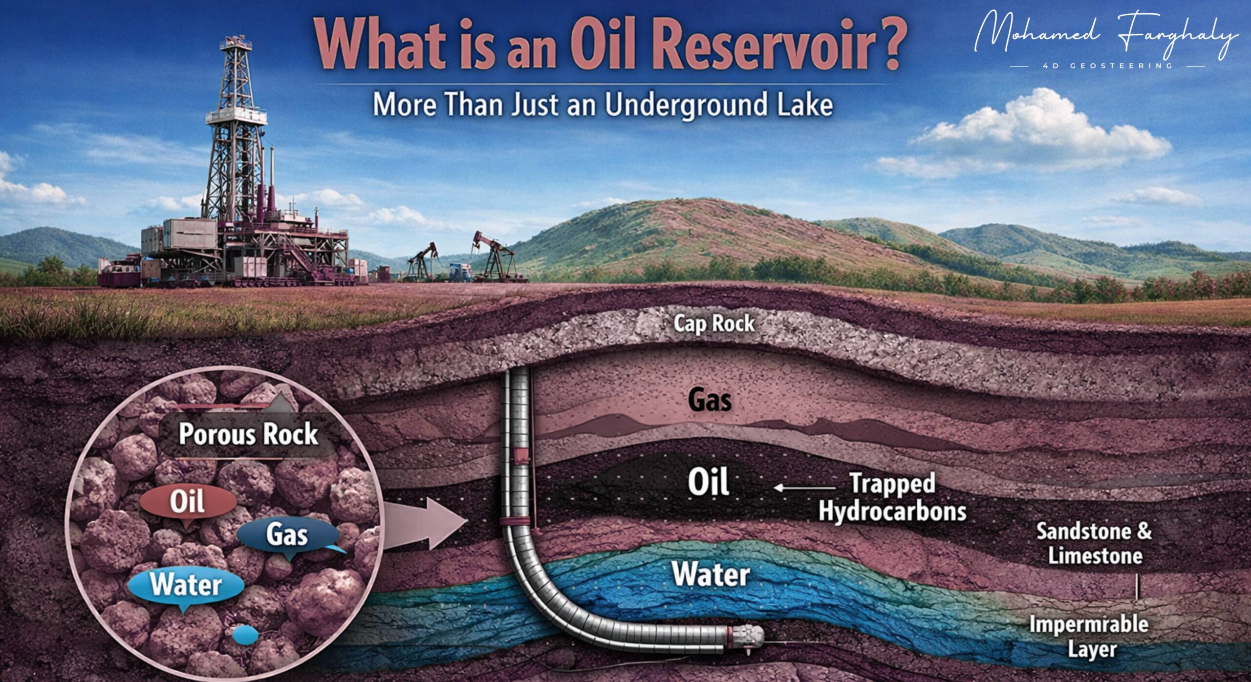
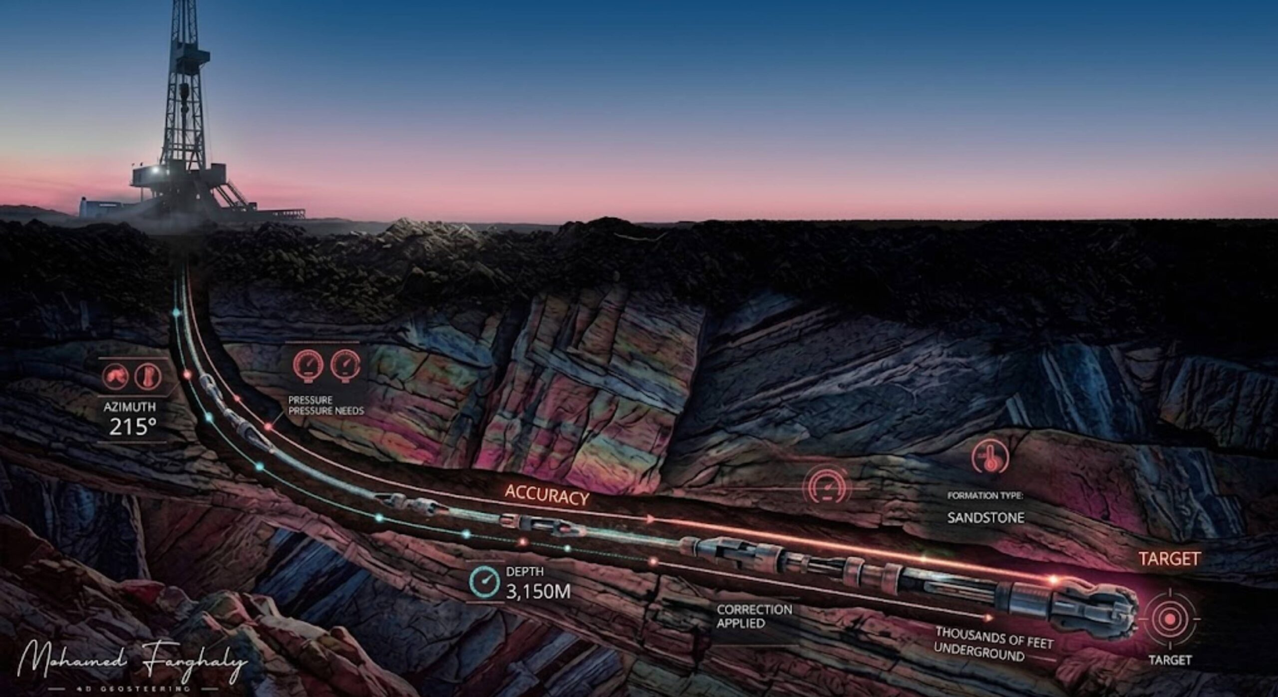
    On a modern Drilling Rig, directional drilling is not simply about steering left or right. It is about hitting a precise subsurface target within an Oil Reservoir while dealing with geological uncertainty, pressure variations, and continuously changing formations. Every adjustment matters, and even a small deviation can move the well away from the optimal zone, directly impacting well placement and production.

    Now, this is where geosteering becomes essential.

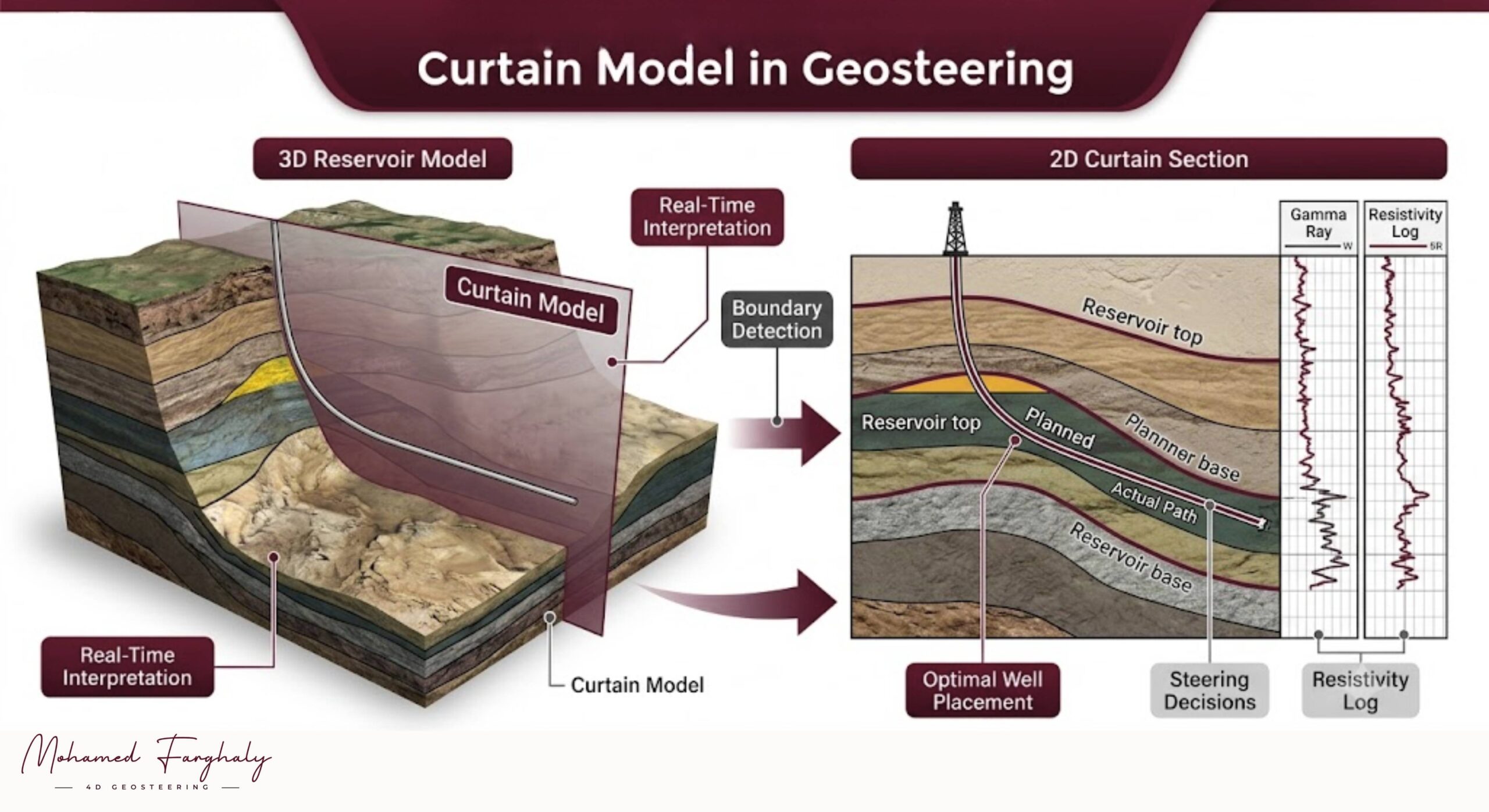
    Directional drilling provides the ability to control the trajectory, but geosteering ensures that this trajectory stays within the most productive part of the reservoir. Without geosteering, directional drilling would lack the real-time geological intelligence needed for accurate decision-making.

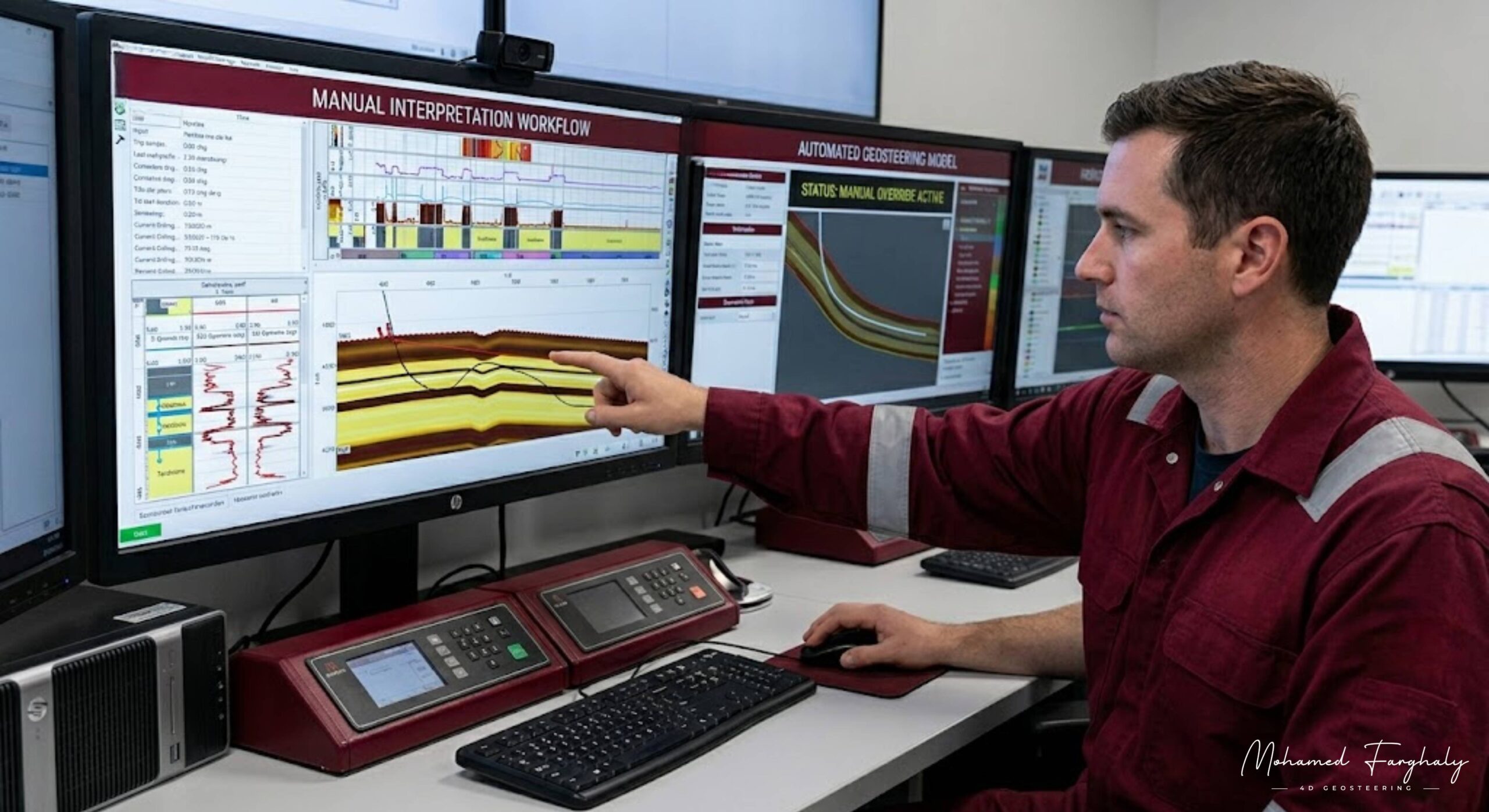
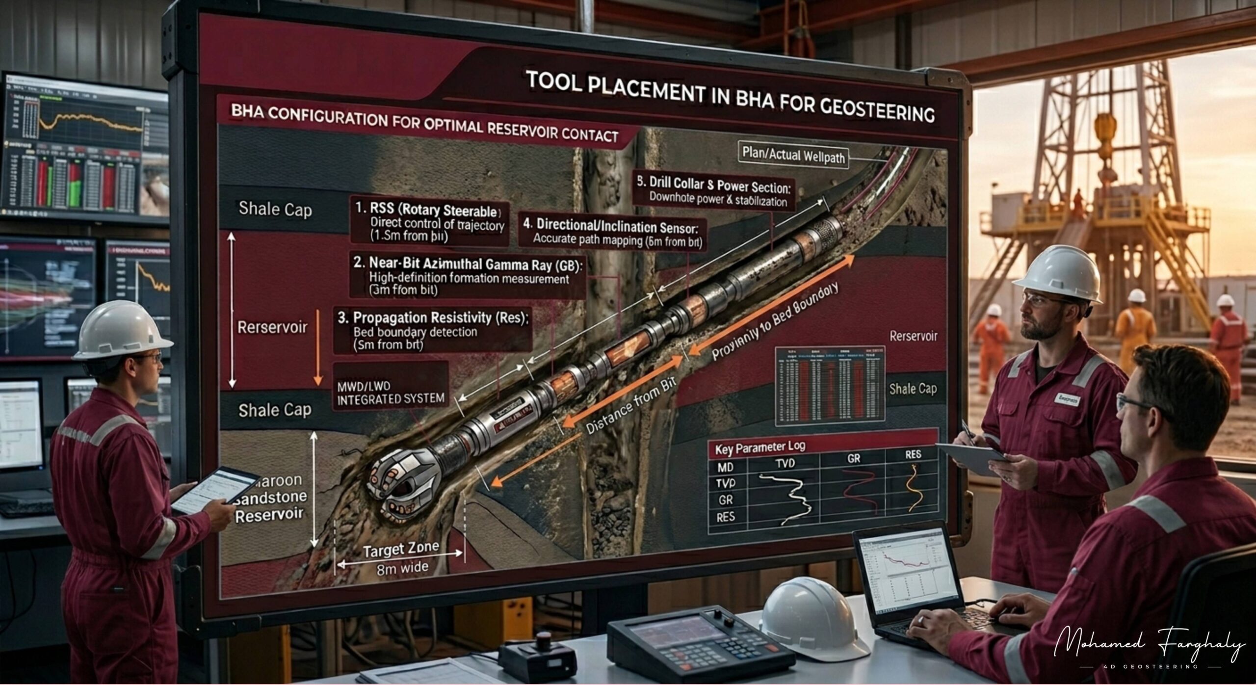
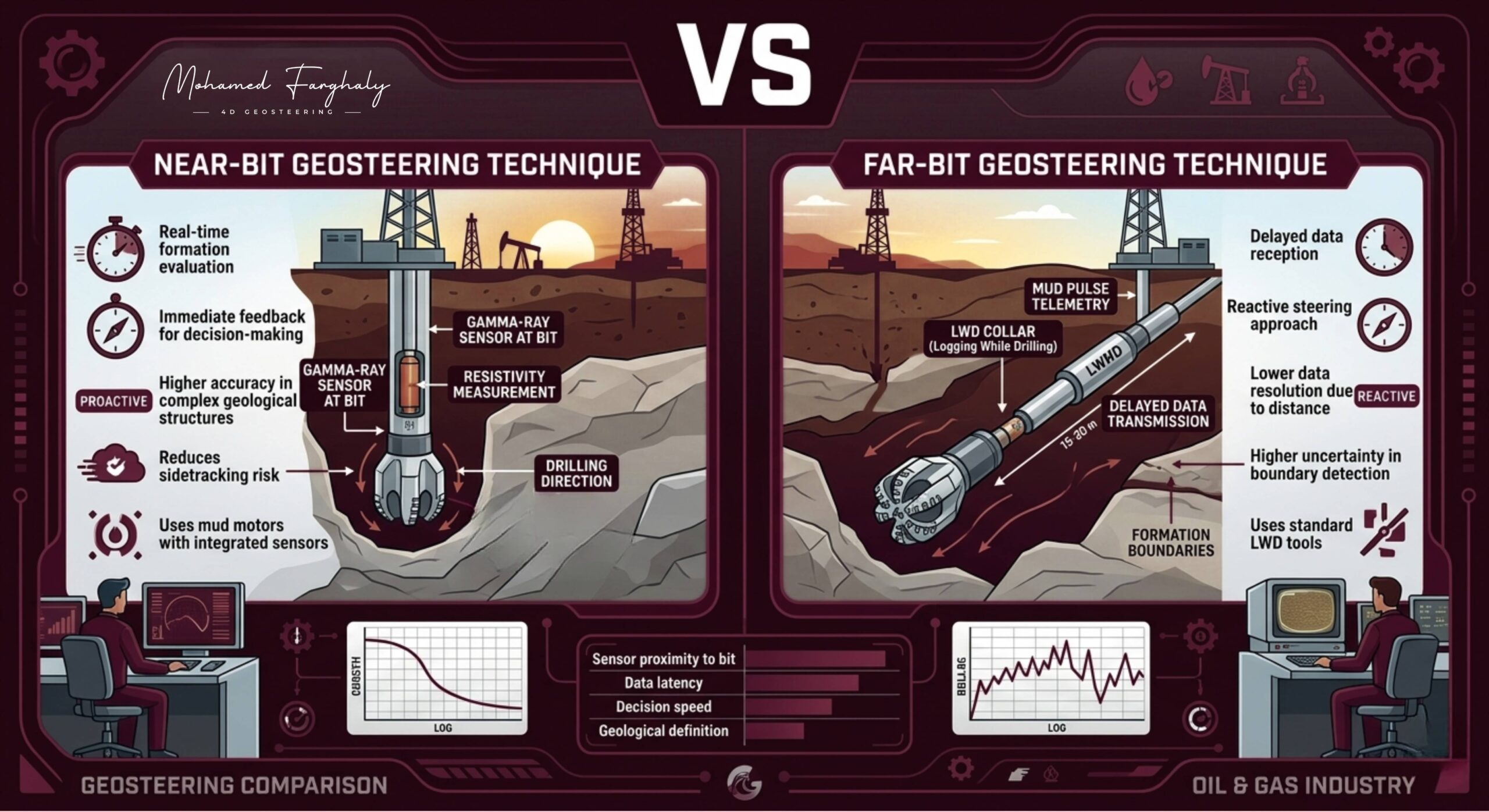
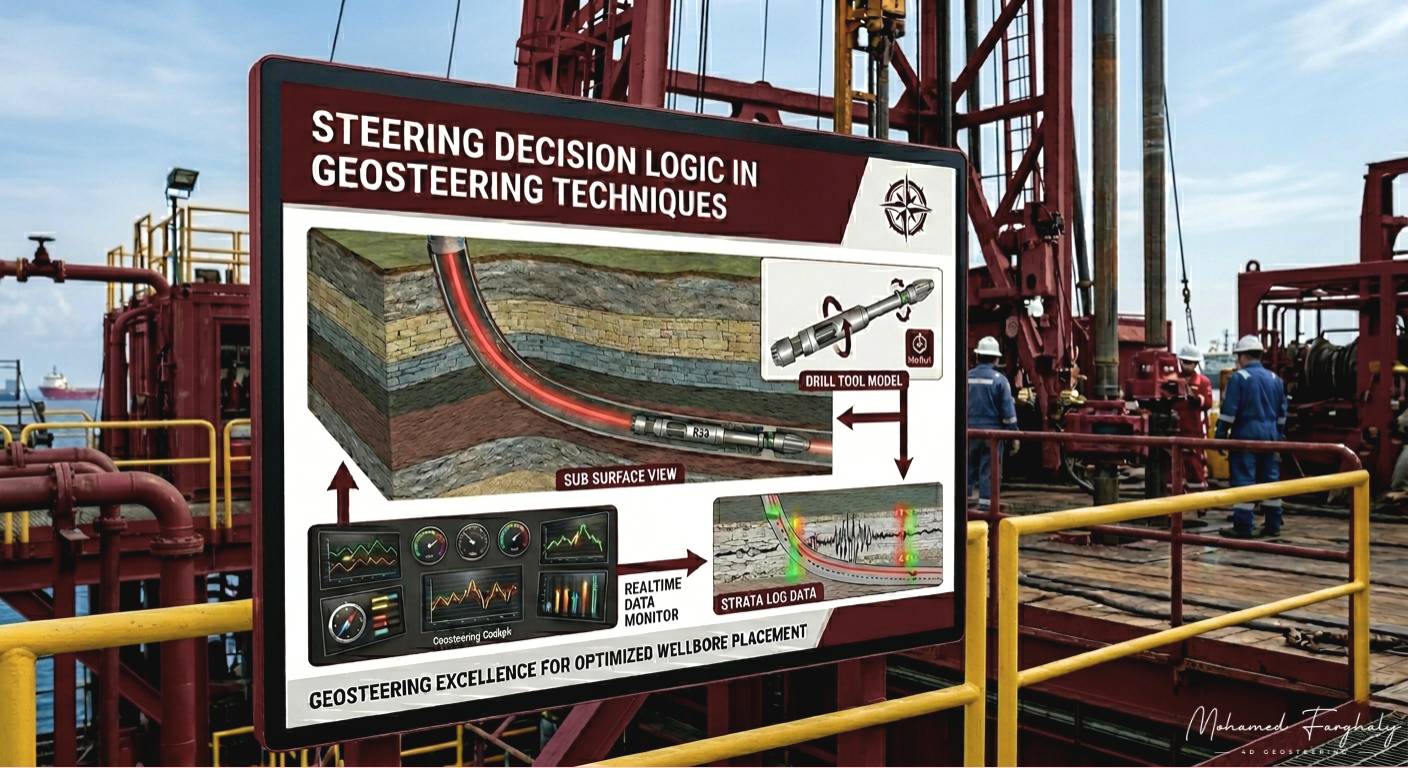
    Imagine trying to pass a thread through a needle while your hands are moving, the needle is shifting, and you are relying only on indirect signals. This is exactly what drilling teams experience. They depend on real-time data from MWD (Measurement While Drilling) and LWD (Logging While Drilling) tools, along with continuous LWD Interpretation, to guide the well along its planned path.

    Advanced measurements, including Electromagnetic Resistivity LWD Tools and Borehole Imaging, provide deeper insights into formation properties. These technologies support accurate reservoir boundary detection, helping teams identify subtle changes and maintain optimal positioning within the reservoir.

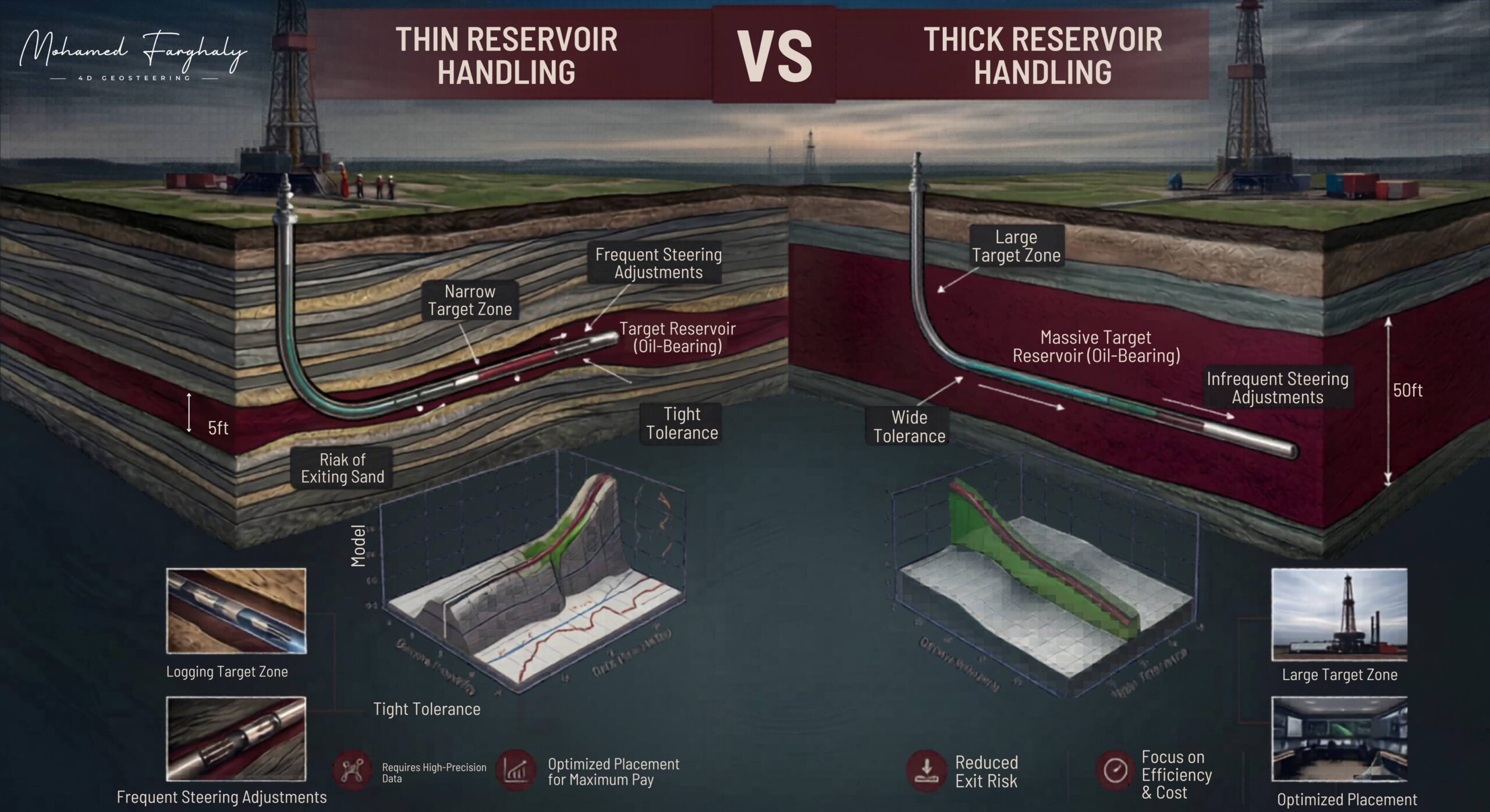
    In horizontal wells, the challenge becomes even greater. The objective is to stay within a thin target zone for as long as possible, which requires constant adjustments to the Bottom Hole Assembly (BHA) and trajectory. Here, directional drilling evolves into a high-precision operation powered by geosteering and the continuous Study of Real-Time LWD Data.

    Today, innovations like Machine Learning and Artificial Intelligence are enhancing directional drilling performance by improving prediction accuracy and enabling faster responses to subsurface changes. These advancements are driving the industry toward the future of automated geosteering, where decisions become smarter and more efficient.

    Many professionals underestimate the level of control required. It is not just drilling—it is continuous correction, interpretation, and anticipation. This is why directional drilling is a fundamental pillar of successful geosteering operations and optimized well placement.

    If you want to understand how wells are drilled with such precision—and how small adjustments create significant results—directional drilling is where that journey begins. But mastering geosteering is what takes that precision to the next level.


    🔗 Keywords

    Drilling Rig, Drilling Mud, MWD, LWD, Directional Drilling, Geosteering, Well Placement, Oil Reservoir, Surface Logging, Borehole Imaging, Electromagnetic Resistivity LWD Tool, Bottom Hole Assembly, Study of Real-Time LWD Data, LWD Interpretation, Borehole Image Log, Dip Calculation Methods, Shale Gas Sweet Spot, Accurate Reservoir Boundary Detection, Machine Learning, Artificial Intelligence, The Future of Automated Geosteering, Ensemble-Based Well Log Interpretation, Digital Twins in Drilling, Remote Operations Centers


  • What is an Oil Reservoir?

    Sept 8, 2024 · 1 minute reading

    Many people imagine an Oil Reservoir as a large underground lake filled with oil—but the reality is very different. A better way to understand it is like a sponge: a solid rock that holds oil, gas, and water within tiny pore spaces.

    Reservoirs are typically formed in porous rocks like sandstone or limestone. Their value depends on two key properties: porosity, which controls how much fluid the rock can store, and permeability, which determines how easily fluids can flow. These factors directly impact production and well placement.

    In modern drilling, understanding the reservoir is essential for effective geosteering. Using real-time data from LWD (Logging While Drilling) and MWD (Measurement While Drilling) tools, engineers continuously analyze formation changes and adjust the well path.

    Advanced technologies like Borehole Imaging and Electromagnetic Resistivity LWD Tools help achieve accurate reservoir boundary detection, ensuring the well stays within the most productive zone.

    Today, Machine Learning and Artificial Intelligence are enhancing reservoir understanding and supporting the future of automated geosteering.

    In simple terms, an oil reservoir is not just a storage system—it is a complex, dynamic formation. And mastering geosteering is the key to unlocking its full potential.


    🔗 Keywords

    Drilling Rig, Drilling Mud, MWD, LWD, Directional Drilling, Geosteering, Well Placement, Oil Reservoir, Surface Logging, Borehole Imaging, Electromagnetic Resistivity LWD Tool, Bottom Hole Assembly, Study of Real-Time LWD Data, LWD Interpretation, Borehole Image Log, Dip Calculation Methods, Shale Gas Sweet Spot, Accurate Reservoir Boundary Detection, Machine Learning, Artificial Intelligence, The Future of Automated Geosteering, Ensemble-Based Well Log Interpretation, Digital Twins in Drilling, Remote Operations Centers


  • The Drilling Mud

    August 20, 2024 ·2 minutes reading

    Many people think Drilling Mud is just “dirty fluid,” but in reality, it is a critical element that directly supports geosteering and safe drilling operations. In modern drilling, geosteering depends heavily on drilling mud performance because it is part of the hidden system that makes accurate geosteering possible from the very beginning to the final Well Placement stage.

    Drilling mud is not just circulated—it is a carefully engineered system that controls pressure, stabilizes the wellbore, cools the drill bit, and transports cuttings to the surface. Without it, maintaining stable conditions for accurate geosteering would be impossible, especially in complex Directional Drilling operations targeting a specific Oil Reservoir zone.

    Why is this important for geosteering?

    Because geosteering depends on reliable downhole conditions and high-quality real-time data. Tools like MWD (Measurement While Drilling) and LWD (Logging While Drilling) require stable environments to provide accurate readings. Poor drilling mud performance can distort data, reduce LWD Interpretation quality, and directly decrease geosteering accuracy, leading to poor reservoir navigation during geosteering operations.

    Every property of drilling mud is precisely controlled. Density maintains pressure balance, viscosity ensures effective cuttings transport, and chemical composition interacts with the formation. These factors directly influence the quality of real-time LWD Interpretation, Study of Real-Time LWD Data, and ultimately the success of geosteering decisions while drilling through the subsurface.

    Drilling mud is also essential for preventing well control issues that could interrupt operations and force delays in geosteering adjustments. Continuous monitoring from the Drilling Rig, Bottom Hole Assembly (BHA), and Surface Logging systems ensures the mud system responds effectively to changing subsurface conditions, keeping geosteering on track.

    Today, advanced technologies like Machine Learning, Artificial Intelligence, and Ensemble-Based Well Log Interpretation are being used to optimize drilling mud behavior and enhance real-time decision-making. This directly strengthens the Future of Automated Geosteering, improving accuracy, efficiency, and confidence in Well Placement inside the reservoir.

    Even innovations like Digital Twins in Drilling and Remote Operations Centers are built around improving geosteering workflows, where drilling mud data plays a key role in simulation and real-time geosteering optimization.

    In simple terms, drilling mud is not just a fluid—it is a key enabler of precise, stable, and successful geosteering, and without it, modern geosteering would not exist in its current advanced form.


    🔗 Keywords

    Drilling Rig, Drilling Mud, MWD, LWD, Directional Drilling, Geosteering, Well Placement, Oil Reservoir, Surface Logging, Borehole Imaging, Electromagnetic Resistivity LWD Tool, Bottom Hole Assembly, Study of Real-Time LWD Data, LWD Interpretation, Borehole Image Log, Dip Calculation Methods, Shale Gas Sweet Spot, Accurate Reservoir Boundary Detection, Machine Learning, Artificial Intelligence, The Future of Automated Geosteering, Ensemble-Based Well Log Interpretation, Digital Twins in Drilling, Remote Operations Centers


  • Risks and Limitations in Geosteering Automation

    May 25, 2023· 1 minute reading

    As the oil and gas industry embraces geosteering automation, operators are gaining access to faster data processing, real-time reservoir insights, and more consistent steering recommendations. Advanced algorithms and artificial intelligence are helping drilling teams navigate complex reservoirs with greater efficiency than ever before. However, automated geosteering systems are only as effective as the data, models, and assumptions behind them. Understanding their limitations is essential for maximizing performance while minimizing risk.

    Data Quality and Reliability

    One of the greatest risks in automated geosteering is poor data quality. Automated systems continuously analyze information from LWD tools, directional surveys, and formation evaluation measurements. If sensors fail, signals are lost, or measurements become noisy, the system may interpret the subsurface incorrectly. Since automation depends heavily on real-time data, inaccurate inputs can quickly lead to inaccurate steering decisions.

    Model Uncertainty and Bias

    Every automated geosteering workflow relies on a geological model. These models are built using available well data, seismic interpretations, and geological assumptions. However, the subsurface rarely behaves exactly as predicted. Model uncertainty, incomplete datasets, and algorithm bias can create misleading predictions about formation boundaries and reservoir properties. When the model differs from reality, automated recommendations may move the wellbore away from the optimal target zone.

    Human-Machine Interaction

    Automation improves speed, but it cannot completely replace geological expertise. A major challenge is maintaining the right balance between automated recommendations and human judgment. Excessive trust in automation can reduce situational awareness, causing critical geological indicators to be overlooked. Experienced geosteering professionals often identify subtle formation changes that algorithms may miss. For this reason, effective operations require a clear manual override capability and continuous expert oversight.

    Geological Variability

    Reservoirs are naturally complex. Faults, unexpected stratigraphic changes, thin reservoir layers, and rapidly changing rock properties can create conditions that differ significantly from the geological model. While automated systems perform well in predictable environments, they may struggle when encountering unexpected geological scenarios. The greater the geological complexity, the more important human interpretation becomes.

    As geosteering automation continues to evolve, its success will depend on combining high-quality data, robust geological models, advanced algorithms, and expert human supervision. The most effective geosteering workflows are not fully automated—they are intelligently assisted, leveraging technology to enhance decision-making while keeping experienced professionals in control of critical operations.


    🔗 Keywords

    Geosteering Automation, Automated Geosteering, Real-Time Geosteering, Machine Learning in Oil and Gas, LWD Data, Formation Evaluation, Well Placement, Geosteering Risks, Geosteering Limitations, Digital Oilfield, Drilling Automation, Reservoir Navigation.


  • Data dependency

    May 24, 2023· 1 minute reading

    The success of geosteering automation depends heavily on one critical factor: data quality. Even the most advanced automation algorithms cannot make accurate steering decisions if the incoming data is incomplete, delayed, or inaccurate.

    Automated geosteering systems rely on continuous real-time inputs from Logging While Drilling (LWD) tools, Measurement While Drilling (MWD) data, geological models, and drilling parameters. These data sources help the system determine the well’s position within the reservoir and recommend the best steering actions.

    Because automation is highly data-dependent, any error in measurements can directly affect well placement. For example, inaccurate resistivity, gamma ray, or directional survey data may cause the system to misinterpret formation boundaries and guide the well away from the target zone.

    To reduce this risk, modern geosteering platforms use data validation, quality control, and data integration techniques. Combining multiple measurements provides a more reliable picture of the subsurface and improves confidence in steering decisions.

    As the industry moves toward greater use of AI-assisted geosteering and automated workflows, the importance of reliable data continues to grow. High-quality real-time data, accurate geological models, and dependable telemetry systems remain the foundation of successful geosteering automation and optimal reservoir placement.


    🔗 Keywords

    Well Correlation, Offset Wells, Formation Tops, Gamma Ray Correlation, Resistivity Trends, LWD Data, Structural Dip, Fault Detection, Stratigraphic Variation, Reservoir Modeling, 3D Geosteering Models, Well Placement Optimization, Geological Uncertainty.


  • Hybrid systems

    May 23, 2023· 3 minutes reading

    A hybrid geosteering system is an integrated workflow that combines automated algorithms with expert geological interpretation to guide drilling decisions. Instead of relying entirely on software or solely on human judgment, hybrid systems merge both strengths into a single adaptive decision-making process.

    These systems typically connect:

    • Real-time MWD/LWD data streams
    • Automated subsurface modeling and updates
    • Machine learning-based pattern recognition
    • Human geologist interpretation and validation
    • Continuous well trajectory optimization

    This integration creates a dynamic system where models are constantly refined while drilling progresses.


    How Hybrid Geosteering Systems Operate

    During drilling operations, hybrid systems continuously analyze incoming logging data such as gamma ray, resistivity, density, and inclination measurements. Automated models quickly update the geological interpretation and predict formation boundaries ahead of the bit.

    At the same time, geosteering engineers evaluate the output by considering:

    • Geological consistency with offset wells
    • Structural and stratigraphic trends
    • Uncertainty ranges in model predictions
    • Operational constraints such as drilling safety and tool limits

    Instead of producing a single deterministic answer, the system presents multiple steering scenarios ranked by probability and geological plausibility. The final decision is made through collaboration between the system and the interpreter.

    This approach is known as a human-in-the-loop geosteering workflow.


    Advantages of Hybrid Systems in Geosteering

    Hybrid systems are becoming essential in modern drilling environments due to their ability to improve both speed and reliability.

    Faster Real-Time Decisions

    Automated processing reduces interpretation time, allowing faster responses to changing subsurface conditions while drilling.

    Higher Geological Confidence

    Human validation ensures that automated predictions remain consistent with realistic geological models.

    Improved Handling of Uncertainty

    Hybrid workflows explicitly manage uncertainty, enabling engineers to evaluate risk before adjusting the well path.

    Enhanced Reservoir Navigation

    Continuous optimization improves the ability to stay within thin or complex reservoir zones, increasing production efficiency.


    Core Technologies Behind Hybrid Geosteering

    Modern hybrid systems are built on a combination of advanced digital tools, including:

    • Machine learning algorithms for log pattern detection
    • Ensemble methods (such as EnRML) for probabilistic modeling
    • Real-time geosteering platforms with cloud-based processing
    • Digital twin models of subsurface geology
    • Automated trajectory optimization engines

    These technologies work together to continuously refine the understanding of the subsurface while drilling is ongoing.


    The Role of Geoscientists in Hybrid Systems

    Rather than replacing geoscientists, hybrid geosteering systems redefine their role. The geologist becomes a real-time decision strategist, responsible for validating automated outputs, interpreting geological context, and guiding the final steering direction.

    This shift allows experts to focus on high-level geological reasoning while automation handles repetitive computation and rapid data processing.


    Future Direction of Geosteering Automation

    Hybrid systems represent a major step toward intelligent drilling operations. As reservoirs become more complex and thin-bed targets more common, the need for integrated human–machine workflows continues to grow.

    The future of geosteering is centered on collaborative intelligence, where automation enhances decision-making rather than replacing it, leading to more precise, efficient, and reliable well placement strategies.


    🔗 Keywords

    Well Correlation, Offset Wells, Formation Tops, Gamma Ray Correlation, Resistivity Trends, LWD Data, Structural Dip, Fault Detection, Stratigraphic Variation, Reservoir Modeling, 3D Geosteering Models, Well Placement Optimization, Geological Uncertainty.


  • Algorithm-based steering

    May 22, 2023· 2 minutes reading

    “What if the well could steer itself… while still thinking like a geologist?”
    This question is no longer science fiction in the oil and gas industry. It reflects the core idea behind algorithm-based steering in geosteering automation, where real-time data, mathematical models, and decision logic work together to guide the wellbore with minimal human intervention.

    In modern geosteering workflows, staying within the target reservoir zone is critical for maximizing production and reducing drilling risks. Traditionally, geosteering depended heavily on human interpretation of LWD/MWD data, real-time correlation, and geological intuition. While effective, this approach can be slow, subjective, and sensitive to uncertainty in complex formations.

    This is where algorithm-based steering systems transform the game. These systems use predefined decision rules, statistical models, and increasingly machine learning algorithms to evaluate incoming real-time data and automatically recommend or execute steering actions. Instead of waiting for manual interpretation cycles, the system continuously updates its understanding of the well position relative to the reservoir.

    At the core of this automation is a feedback loop. Measurement-while-drilling data (such as gamma ray, resistivity, and inclination) is streamed into the system, where algorithms compare it against a pre-built geological model. The system then calculates the probability of staying within the reservoir and determines the optimal next drilling direction. This allows for faster reactions to boundary approaches and thin-bed transitions.

    Advanced implementations also include probabilistic steering logic, where multiple geological scenarios are evaluated simultaneously. Rather than relying on a single “best guess,” the algorithm ranks possible outcomes and selects the steering decision that maximizes reservoir exposure while minimizing uncertainty. This is especially powerful in heterogeneous and structurally complex reservoirs, where manual interpretation can struggle to keep up.

    Another key advantage is consistency. Unlike human-driven decisions, algorithm-based steering applies the same logic under all conditions, reducing variability between different geosteering teams and shifts. It also improves operational efficiency, enabling faster drilling response times and better well placement accuracy.

    As digital oilfields evolve, algorithm-based steering is becoming a core pillar of automated geosteering systems, bridging the gap between human expertise and machine precision.


    🔗 Keywords

    Well Correlation, Offset Wells, Formation Tops, Gamma Ray Correlation, Resistivity Trends, LWD Data, Structural Dip, Fault Detection, Stratigraphic Variation, Reservoir Modeling, 3D Geosteering Models, Well Placement Optimization, Geological Uncertainty.


  • Manual interpretation workflow

    May 21, 2023· 2 minutes reading

    In today’s oil and gas industry, geosteering automation systems can process real-time data in seconds, but the subsurface still refuses to behave in a fully predictable way. That is exactly why the manual interpretation workflow in geosteering remains a core part of successful well placement decisions, especially in complex and thin reservoirs where small geological changes can completely change drilling outcomes.

    The manual interpretation workflow starts with continuous tracking of real-time LWD (Logging While Drilling) data such as gamma ray, resistivity, density, neutron porosity, and wellbore inclination. These measurements are streamed into interpretation systems and compared against the pre-drill geological model. While automation provides quick model updates, interpreters manually evaluate whether the response truly reflects the formation or if it is influenced by drilling conditions, tool behavior, or structural uncertainty.

    A key part of the workflow is data quality control and filtering. Not every signal coming from downhole tools is directly interpretable. Engineers must distinguish between true formation changes and noise caused by borehole effects, tool standoff, or drilling dynamics. This step is critical because incorrect interpretation at this stage can lead to poor steering decisions.

    After that comes real-time correlation and geological matching, where interpreters align observed responses with expected stratigraphic markers. They manually identify bed boundaries, faults, formation dips, and thickness variations, often adjusting the geological model to better fit reality. In many cases, the manual update is what prevents the well from exiting the target zone.

    Another important stage is model updating and calibration. When mismatches appear between measured data and predicted trends, interpreters adjust parameters such as structural dip, layer thickness, and reservoir position. This keeps the geosteering model continuously aligned with actual subsurface conditions rather than relying on static assumptions.

    The workflow also includes decision-making under uncertainty, where automation may suggest steering actions, but human experts evaluate geological plausibility, operational risks, and drilling constraints before approving any change in trajectory. This human layer ensures that decisions are not only fast but also geologically reliable.

    Finally, manual interpretation directly supports real-time communication with the drilling team, translating geological understanding into actionable steering instructions that control directional drilling tools and keep the well within the reservoir sweet spot.


    🔗 Keywords

    Well Correlation, Offset Wells, Formation Tops, Gamma Ray Correlation, Resistivity Trends, LWD Data, Structural Dip, Fault Detection, Stratigraphic Variation, Reservoir Modeling, 3D Geosteering Models, Well Placement Optimization, Geological Uncertainty.


  • The Power of Offset Wells

    May 20, 2023 · 3 minutes reading

    Every successful well carries a story—and more importantly, valuable data that can shape the next one. In the oil and gas industry, offset wells are not just historical records; they are powerful tools that reduce risk, improve Well Placement, and enhance overall drilling performance. Leveraging past successes is often the difference between uncertainty and precision.

    Offset wells provide critical insights into the behavior of the Oil Reservoir, including formation tops, fluid contacts, pressure regimes, and lithology variations. By analyzing this data, engineers can design more accurate Directional Drilling plans and anticipate potential challenges before drilling even begins. Instead of relying solely on theoretical models, teams build strategies based on real, proven subsurface information.

    One of the most impactful applications of offset well data is in Geosteering. Historical MWD and LWD data from nearby wells help define expected trends in resistivity, gamma ray, and other formation properties. This allows for better LWD Interpretation and a more reliable Study of Real-Time LWD Data during drilling. When the real-time data aligns with offset trends, confidence in decision-making increases. When it doesn’t, teams can quickly recognize anomalies and adjust accordingly.

    Advanced datasets from offset wells, such as Borehole Imaging and Borehole Image Log, provide detailed structural information about fractures, bedding, and formation dips. Using Dip Calculation Methods, geoscientists can predict formation orientation and improve trajectory control. Tools like the Electromagnetic Resistivity LWD Tool further enhance the ability to correlate with offset data and support Accurate Reservoir Boundary Detection.

    Offset wells also play a key role in optimizing drilling performance. Information about Bottom Hole Assembly configurations, drilling parameters, and Drilling Mud properties helps engineers replicate successful approaches and avoid past mistakes. Additionally, Surface Logging data offers insights into cuttings and gas behavior, improving real-time interpretation during operations.

    In unconventional reservoirs, identifying and staying within a Shale Gas Sweet Spot becomes much easier when guided by offset well performance. Patterns observed in previous wells can highlight the most productive zones and inform better targeting strategies.

    With the integration of Machine Learning, Artificial Intelligence, and Digital Twins in Drilling, offset well data is becoming even more valuable. These technologies analyze historical datasets to predict outcomes, optimize well paths, and support decision-making in Remote Operations Centers. This evolution is driving the industry toward The Future of Automated Geosteering, where past and present data work together seamlessly.

    Offset wells prove that success leaves clues. By learning from what has already been drilled, operators can reduce uncertainty, improve efficiency, and consistently deliver better wells.


    🔗 Keywords

    Drilling Rig, Drilling Mud, MWD, LWD, Directional Drilling, Geosteering, Well Placement, Oil Reservoir, Surface Logging, Borehole Imaging, Electromagnetic Resistivity LWD Tool, Bottom Hole Assembly, Study of Real-Time LWD Data, LWD Interpretation, Borehole Image Log, Dip Calculation Methods, Shale Gas Sweet Spot, Accurate Reservoir Boundary Detection, Machine Learning, Artificial Intelligence, The Future of Automated Geosteering, Ensemble-Based Well Log Interpretation, Digital Twins in Drilling, Remote Operations Centers


  • Model assumptions

    May 20, 2023· 1 minute reading

    “Everyone trusts the geosteering model… but few realize it is built on hidden assumptions that can quietly reshape the well path.”

    In geosteering, every real-time decision in the oil and gas industry depends on a subsurface model that guides well placement—but that model is never a perfect representation of reality. Instead, it is built on assumptions that make interpretation possible under uncertainty, and these assumptions directly influence how confidently we steer the well.

    One of the most important is layer continuity, where formations are assumed to extend laterally between control points. This makes well-to-well correlation possible, but real reservoirs often contain faults, channels, and pinch-outs that break continuity and shift targets unexpectedly.

    Another major assumption is uniform petrophysical properties within a geological zone. Models often treat porosity, resistivity, and lithology as consistent, but in reality reservoirs are highly heterogeneous. This can distort LWD (Logging While Drilling) responses and lead to incorrect boundary interpretation.

    We also rely on simplified structural geometry, assuming layers are flat or gently dipping. However, folds and fault systems can significantly alter true bed positions compared to the predicted model.

    Finally, geosteering assumes accurate measurements and static geology during interpretation, even though both data uncertainty and evolving interpretations continuously reshape understanding while drilling is ongoing.

    Understanding these model assumptions in geosteering is not about eliminating them—it’s about recognizing their limits. The better we see what is simplified, the better we can adapt in real time and keep the well within the target zone.


    🔗 Keywords

    Well Correlation, Offset Wells, Formation Tops, Gamma Ray Correlation, Resistivity Trends, LWD Data, Structural Dip, Fault Detection, Stratigraphic Variation, Reservoir Modeling, 3D Geosteering Models, Well Placement Optimization, Geological Uncertainty.


  • Correlation between wells

    May 18, 2023· 2 minutes reading

    What if the key to successfully steering your current well is not actually inside the well you are drilling—but hidden in the data of wells drilled kilometers away?

    In geosteering, this is not just a possibility, it is a daily reality. Every drilling decision is built on the ability to understand how the subsurface geology changes laterally and vertically across a field. While real-time LWD (Logging While Drilling) data provides immediate feedback from the current well, it is the integration with offset well correlation that gives meaning to those signals.

    Well correlation is the process of linking geological information between multiple wells to build a consistent and reliable subsurface model. It starts by identifying shared geological markers such as formation tops, gamma-ray peaks, resistivity trends, and distinctive lithological boundaries. When these features are matched across different wells, they reveal how the reservoir behaves across space—whether it is stable, thinning, thickening, or structurally displaced.

    Before drilling even begins, correlation plays a critical role in building the initial geosteering model. Data from surrounding wells is used to define the expected reservoir depth, structural dip, and possible fault zones. This allows geoscientists to design a well trajectory that stays within the most productive part of the reservoir, while also accounting for geological uncertainty.

    During drilling, the importance of correlation becomes even more evident. As LWD measurements come in, they are constantly compared to the predicted responses derived from offset wells. When the real-time data matches the correlated model, confidence in the geological interpretation increases. However, when differences appear, geosteering teams must quickly evaluate whether they are seeing a structural shift, a stratigraphic variation, a fault intersection, or a change in reservoir quality.

    In more complex reservoirs, a single well can be misleading. Correlation across multiple wells often reveals subtle regional trends, such as gradual reservoir thinning in one direction or consistent structural stepping between fault blocks. These patterns are invisible without integrating multiple data points, yet they directly influence well placement decisions and steering strategy.

    Modern 3D geosteering models rely heavily on continuous updates from new wells. Each drilled well improves the correlation framework, refining the understanding of the reservoir and reducing uncertainty for future operations. Over time, the field evolves from isolated well interpretations into a connected and dynamic geological model.

    In this way, well correlation is not just a support tool—it is the foundation that connects real-time drilling decisions to the broader geological picture, ensuring that every meter drilled is guided by a deeper understanding of the reservoir system.


    🔗 Keywords

    Well Correlation, Offset Wells, Formation Tops, Gamma Ray Correlation, Resistivity Trends, LWD Data, Structural Dip, Fault Detection, Stratigraphic Variation, Reservoir Modeling, 3D Geosteering Models, Well Placement Optimization, Geological Uncertainty.


  • Structural vs Stratigraphic Models

    May 16, 2023· 3 minutes reading

    In modern geosteering, accurately placing a well within the most productive part of a reservoir depends on having a reliable geological model. Two of the most widely used approaches are structural models and stratigraphic models. Understanding the difference between these models is essential for improving well placement, maximizing reservoir contact, and reducing drilling uncertainty in the oil and gas industry.

    A structural model focuses on the geometry of the subsurface. It is designed to represent geological features such as faults, folds, formation dips, and structural offsets. In reservoirs affected by tectonic activity, structural interpretation becomes critical because even small changes in formation position can cause a horizontal well to exit the target zone. During real-time geosteering, geologists continuously compare LWD (Logging While Drilling) measurements with the structural model to identify approaching faults, update formation tops, and make steering corrections before reservoir contact is lost.

    A stratigraphic model, on the other hand, focuses on the depositional architecture of the reservoir. Instead of tracking structural movement, it follows changes in lithology, facies, rock properties, and sedimentary sequences. This approach is especially useful in reservoirs where production performance is controlled by depositional patterns rather than structural complexity. By recognizing distinctive stratigraphic markers, geosteering teams can stay within the highest-quality reservoir intervals and avoid non-productive zones.

    In many modern fields, neither model alone provides a complete picture. Advanced geosteering software often combines both structural and stratigraphic interpretations to create a dynamic model that updates continuously as new drilling data becomes available. This integrated approach allows teams to make faster and more confident steering decisions while drilling.

    Structural vs Stratigraphic Models Comparison

    FeatureStructural ModelStratigraphic Model
    Primary FocusFaults, folds, and formation geometryFacies, lithology, and depositional layers
    Main ObjectiveMaintain structural position within the reservoirMaintain stratigraphic position within the reservoir
    Best ApplicationStructurally complex reservoirsLayered sedimentary reservoirs
    Key Data SourcesFormation tops, dips, fault interpretationRock properties, facies, and stratigraphic markers
    Main ChallengePredicting structural changes and fault crossingsTracking lateral reservoir variations
    Geosteering BenefitImproved navigation through complex structuresBetter targeting of high-quality reservoir zones

    Why Both Models Matter in Modern Geosteering

    As reservoirs become more challenging to develop, successful geosteering operations increasingly rely on a combination of structural modeling and stratigraphic modeling. Structural models help geologists understand where formations are located, while stratigraphic models explain how reservoir quality changes within those formations. Together, they provide a more complete understanding of the subsurface, enabling better well trajectory optimization, improved formation evaluation, and higher drilling success rates.

    By integrating both approaches, operators can reduce uncertainty, improve reservoir exposure, and maximize the value of every drilled foot—making structural and stratigraphic models fundamental components of modern geosteering workflows.


    🔗 Keywords

    Geosteering, Structural Model, Stratigraphic Model, Oil and Gas, Well Placement, Horizontal Drilling, LWD, Formation Evaluation, Reservoir Modeling, Real-Time Geosteering, Directional Drilling, Reservoir Characterization, Well Trajectory Optimization, Geosteering Software, Subsurface Interpretation.


  • Curtain model concept in Geosteering

    May 15, 2023· 2 minutes reading

    Imagine drilling a horizontal well through a reservoir that is only a few feet thick. Staying inside the productive zone requires more than just following a planned trajectory—it requires a clear understanding of the geological boundaries around the wellbore in real time. This is where the Curtain Model becomes an important visualization tool in modern geosteering.

    The Curtain Model is a simplified geological representation that displays the relationship between the well trajectory and surrounding formation boundaries along the drilled path. Instead of viewing the reservoir as a complex three-dimensional model, the geological layers are “unfolded” into a vertical curtain-like section that follows the wellbore. This allows geosteering teams to quickly interpret the position of the drill bit relative to key geological markers and reservoir boundaries.

    In practical operations, the Curtain Model is continuously updated using Logging While Drilling (LWD) measurements such as gamma ray, resistivity, and other formation evaluation data. As new data arrives from the well, geologists compare the measured responses with the expected geological model and adjust the interpretation accordingly. The updated curtain view helps identify approaching roof or floor boundaries, structural changes, and reservoir thickness variations before the well exits the target zone.

    One of the biggest advantages of the Curtain Model is its ability to simplify decision-making. Rather than analyzing complex 3D geological models during fast-paced drilling operations, geosteering specialists can quickly evaluate the well’s position within a single continuous cross-sectional view. This improves communication between geologists, drilling engineers, and directional drillers while supporting faster steering decisions.

    Although the Curtain Model is highly effective for real-time visualization, it is still a simplified representation of the subsurface. It must be integrated with detailed geological models, seismic interpretation, and operational experience to achieve optimal well placement. When combined with modern reservoir modeling and advanced LWD technologies, the Curtain Model remains one of the most valuable tools for maximizing reservoir contact and improving drilling performance in today’s oil and gas industry.


    🔗 Keywords

    Geosteering, Curtain Model, Earth Model, LWD, Real-Time Geosteering, Reservoir Navigation, Well Placement, Formation Boundaries, Horizontal Drilling, Oil and Gas Geosteering.


  • Rig Types and Components

    May 10, 2023· 2 minutes reading

    What actually makes a Drilling Rig capable of drilling deep into the earth with such precision? It’s not just a tall steel structure—it’s a fully integrated system where every part works together to deliver safe and efficient operations. In today’s oil and gas industry, understanding rig types and components is essential, especially with the growing importance of Directional Drilling, Well Placement, and Geosteering.

    Drilling rigs are mainly classified by location. Land rigs are used onshore and vary from small mobile units to large systems designed for deep and complex wells targeting valuable Oil Reservoir zones. Offshore rigs, on the other hand, include jack-ups for shallow water, semi-submersibles for deeper conditions, and drillships for ultra-deepwater operations. Each type is selected based on environment, depth, and drilling objectives, ensuring optimal performance and safety.

    At the core of every Drilling Rig are key components that enable the drilling process. The derrick supports vertical operations, while the hoisting system handles heavy loads like drill pipes. The rotary system, often powered by a top drive, rotates the drill string and the Bottom Hole Assembly, which carries essential tools for drilling and measurement. The circulation system pumps Drilling Mud through the well, cooling the bit, removing cuttings, and maintaining pressure. This fluid also supports Surface Logging, providing valuable data about subsurface formations.

    Modern rigs are equipped with advanced technologies such as MWD and LWD, which allow continuous monitoring of downhole conditions. These tools enable the Study of Real-Time LWD Data and accurate LWD Interpretation, helping engineers make better decisions while drilling. Technologies like the Electromagnetic Resistivity LWD Tool and Borehole Imaging, including Borehole Image Log, improve formation evaluation and support Accurate Reservoir Boundary Detection.

    All these components work together as one system, making the rig more than just machinery. It becomes a platform for precision and adaptability, especially when applying Geosteering to keep the well within the most productive zones, such as a Shale Gas Sweet Spot.

    With the rise of Machine Learning, Artificial Intelligence, and Digital Twins in Drilling, rigs are becoming smarter and more efficient. Supported by Remote Operations Centers and moving toward The Future of Automated Geosteering, drilling operations are evolving faster than ever.

    In the end, a Drilling Rig is the foundation of successful drilling. Its components and technologies directly impact performance, cost, and the ability to deliver high-quality wells.


    🔗 Keywords

    Drilling Rig, Drilling Mud, MWD, LWD, Directional Drilling, Geosteering, Well Placement, Oil Reservoir, Surface Logging, Borehole Imaging, Electromagnetic Resistivity LWD Tool, Bottom Hole Assembly, Study of Real-Time LWD Data, LWD Interpretation, Borehole Image Log, Dip Calculation Methods, Shale Gas Sweet Spot, Accurate Reservoir Boundary Detection, Machine Learning, Artificial Intelligence, The Future of Automated Geosteering, Ensemble-Based Well Log Interpretation, Digital Twins in Drilling, Remote Operations Centers


  • Tool Placement in BHA in Geosteering

    May 8, 2023· 2 minutes reading

    In modern geosteering operations, success is not determined only by the quality of geological interpretation or the accuracy of formation evaluation. One of the most critical factors behind precise well placement is tool placement inside the Bottom Hole Assembly (BHA). The position of each measurement tool relative to the drill bit directly affects how quickly the drilling team detects formation changes and reacts to them in real time.

    The Bottom Hole Assembly (BHA) is the lower section of the drill string that includes the drill bit, motors, stabilizers, and measurement tools such as MWD (Measurement While Drilling) and LWD (Logging While Drilling) sensors. In geosteering, the placement of these tools determines whether the team receives early warnings about formation boundaries or delayed information after the bit has already exited the target zone.

    One of the most important concepts in BHA design is the difference between near-bit and far-bit sensor placement. Near-bit tools are positioned very close to the drill bit, sometimes only a few feet away. This setup allows geosteering teams to detect lithology changes almost immediately, reducing reaction time and improving steering precision in thin reservoirs. Near-bit measurements are especially valuable in highly complex formations where rapid geological decisions are required.

    On the other hand, far-bit tools are located farther behind the bit in the BHA. Although they may provide higher-quality or more stable measurements, the data arrives later because the bit has already drilled ahead before the formation is evaluated. This delay can increase the risk of exiting the reservoir before corrective steering actions are taken.

    The placement of tools also depends on the drilling objective and reservoir characteristics. In thin reservoirs, operators often prefer near-bit gamma ray or resistivity tools to maximize wellbore exposure within the productive zone. In thicker formations, slightly farther tool placement may still provide sufficient reaction time while improving data reliability.

    Modern geosteering operations carefully optimize BHA configurations to balance measurement accuracy, response time, drilling efficiency, and well placement precision. As drilling technologies continue to evolve, intelligent BHA designs are becoming essential for reducing uncertainty and improving reservoir navigation in increasingly challenging wells.


    🔗 Keywords


  • Near-bit vs far-bit techniques comparison

    May 6, 2023· 2 minutes reading

    In modern geosteering, one of the biggest challenges is understanding where the wellbore is heading before the drill bit exits the target zone. This is where near-bit and far-bit measurement techniques become essential. Both methods help geosteering teams make real-time steering decisions, but they provide different levels of visibility into the formation ahead of the bit.

    What Are Near-Bit Techniques?

    Near-bit measurements are taken very close to the drill bit, sometimes only a few feet behind it. These measurements provide immediate information about the formation currently being drilled. Because the sensors are close to the bit, the response is fast and highly accurate for identifying lithology changes, bed boundaries, and reservoir entry or exit points.

    Near-bit techniques are extremely valuable in thin reservoirs, where even small trajectory changes can move the well outside the productive zone. Geosteering teams rely on near-bit data for rapid corrections and maintaining precise well placement.

    However, near-bit measurements mainly show what the bit is drilling right now, not what lies ahead. This limits the ability to predict approaching geological changes early.

    What Are Far-Bit Techniques?

    Far-bit techniques look deeper into the formation ahead of the drill bit using advanced resistivity and electromagnetic technologies. Instead of only measuring the current formation, these tools help geosteerers detect approaching boundaries, fluid contacts, or formation changes before the bit reaches them.

    This predictive capability gives drilling teams more time to adjust the trajectory proactively rather than reactively. Far-bit measurements are especially useful in complex structures, faulted reservoirs, and wells requiring long horizontal exposure.

    The tradeoff is that far-bit measurements may have lower resolution compared to near-bit tools and can involve more interpretation uncertainty.

    Near-Bit vs Far-Bit Comparison

    FeatureNear-Bit TechniquesFar-Bit Techniques
    Sensor PositionVery close to the drill bitDeeper investigation ahead of bit
    Main PurposeImmediate formation evaluationPredictive boundary detection
    Response SpeedVery fastSlightly slower interpretation
    Best ForThin reservoirs and precise controlComplex geology and proactive steering
    Data TypeCurrent formationUpcoming formation trends
    Risk ReductionCorrects trajectory quicklyPrevents unexpected exits early

    Why Both Techniques Matter

    In today’s geosteering workflows, operators often combine both methods to achieve better reservoir navigation. Near-bit measurements provide high-confidence real-time positioning, while far-bit technologies improve anticipation of geological changes ahead.

    The combination allows geosteering teams to reduce uncertainty, improve well placement accuracy, minimize non-productive drilling, and maximize reservoir contact. As drilling environments become more complex, integrating both near-bit and far-bit techniques is becoming a major advantage in the oil and gas industry.


    🔗 Keywords


  • Thin vs thick reservoir handling

    May 4, 2023· 3 minutes reading

    One of the biggest challenges in geosteering is understanding how drilling strategy changes between thin reservoirs and thick reservoirs. While both types of reservoirs may contain valuable hydrocarbons, the way they are handled during drilling can be completely different.

    The thickness of a reservoir directly affects well placement, steering sensitivity, operational risk, and the overall level of precision required from the geosteering team. Because of this, geosteerers must constantly adapt their interpretation and steering approach based on reservoir geometry.

    In thick reservoirs, geosteering is generally more forgiving. The target zone provides a larger vertical window, allowing the well to remain inside the reservoir even if small trajectory deviations occur. Minor changes in formation dip, delayed responses from Logging While Drilling (LWD) tools, or slight steering corrections usually do not immediately place the well outside the productive interval.

    This wider target window allows geosteerers to focus more on optimizing lateral placement, maximizing reservoir exposure, and maintaining drilling efficiency. In many cases, thick reservoirs reduce the operational pressure associated with rapid steering corrections because there is more room for adjustment.

    However, thin reservoirs create a completely different environment. In these formations, the distance between the top and bottom boundaries may only be a few feet. A small error in interpretation or a delayed steering response can quickly place the drill bit outside the target zone.

    This is where real-time interpretation becomes critical. Geosteerers working in thin reservoirs must monitor subtle changes in gamma ray, resistivity, and other LWD measurements to detect approaching boundaries as early as possible. Even slight log variations may indicate that the well is moving closer to shale, water zones, or non-productive formations.

    Thin reservoir handling also requires stronger integration between geology, directional drilling, and operational decision-making. Steering corrections must often happen earlier and more proactively compared to thick reservoirs. Instead of reacting after crossing a boundary, geosteerers try to anticipate geological movement ahead of the bit.

    Another major challenge in thin reservoirs is measurement positioning. Since many LWD sensors are positioned behind the bit, there can be a delay between the actual geological change and when it appears on the logs. In a thick reservoir, this delay may have limited impact. In a thin reservoir, even a short delay can significantly affect well placement accuracy.

    Structural complexity also plays a larger role in thin formations. Small changes in formation dip, faulting, or stratigraphic variability can rapidly alter the position of reservoir boundaries. Because of this, geosteerers often update structural interpretations continuously while drilling progresses.

    Modern geosteering software helps improve thin reservoir navigation through advanced visualization, boundary detection, and predictive modeling. Still, experienced geosteerers rely heavily on geological reasoning, pattern recognition, and understanding reservoir behavior in real time.

    In the end, the difference between handling thin and thick reservoirs is not simply about reservoir size. It is about how much precision, anticipation, and real-time adaptability are required to keep the well inside the most productive part of the formation.

    In geosteering, the thinner the reservoir, the more valuable accurate interpretation becomes.


    🔗 Keywords


  • Steering Decision Logic in Geosteering

    May 3, 2023· 2 minutes reading

    In geosteering, every adjustment made while drilling follows a process known as steering decision logic. This is the system of interpretation, analysis, and operational thinking used to decide whether the well should continue its current path, change inclination, adjust azimuth, or hold trajectory inside the target formation.

    Unlike traditional geology workflows that rely heavily on post-drill analysis, geosteering happens in real time. Decisions must often be made within minutes while the drill bit continues advancing through the subsurface. Because of this, steering decisions are based on combining multiple sources of information together rather than depending on a single measurement.

    The first part of steering decision logic begins with analyzing Logging While Drilling (LWD) data. Measurements such as gamma ray, resistivity, density, and neutron logs help geosteerers identify formation changes, approaching boundaries, and reservoir characteristics. These measurements are continuously compared against the planned geological model.

    However, steering decisions are not made from logs alone. Geosteerers also evaluate well trajectory, formation dip, structural uncertainty, drilling trends, and the expected behavior of the reservoir ahead of the bit. In many cases, the goal is not simply to react to data but to predict geological movement before the bit reaches it.

    For example, if resistivity values begin decreasing while gamma ray increases, this may indicate that the well is approaching a shale boundary. The steering decision logic then focuses on determining whether the boundary is temporary, structural, or part of a larger geological shift. Based on this interpretation, the team may decide to steer upward, downward, or maintain the current path.

    One of the most important aspects of steering decision logic is balancing geological interpretation with operational limitations. Even if geology suggests an immediate correction, factors such as dogleg severity, BHA limitations, drilling efficiency, and directional drilling capabilities must also be considered before making trajectory changes.

    In complex reservoirs, steering decisions often involve uncertainty. The subsurface rarely behaves exactly as predicted, which is why experienced geosteerers rely heavily on pattern recognition, geological reasoning, and continuous model updates. Small changes in data trends can completely change the interpretation of reservoir position.

    Modern real-time operations centers use advanced visualization software and automated modeling systems to support steering decisions. These tools help integrate geological models, well paths, and live measurements into a single workflow. However, human interpretation remains essential because geological complexity cannot always be fully predicted by software alone.

    At its core, steering decision logic is the process of transforming real-time subsurface data into actionable drilling decisions. It connects geology, drilling engineering, and operational awareness into one continuous workflow designed to maximize reservoir exposure and improve well placement accuracy.

    In modern geosteering, successful wells are not guided by data alone. They are guided by the quality of the decisions made from that data.


  • Measurement positioning

    May 2, 2023· 2 minutes reading

    In geosteering, every decision depends on data. But one critical detail is often overlooked by beginners: where that data is actually being measured from. This is the foundation of measurement positioning.

    During drilling, measurements are not always taken directly at the drill bit. In many cases, the sensors inside the Bottom Hole Assembly (BHA) are positioned several feet behind the bit. While this may sound like a small technical detail, it can significantly affect how geosteering decisions are made in real time.

    When a formation boundary appears on a log, the drilling bit may have already moved beyond that exact point. This creates what geosteering teams call a measurement lag. Understanding this lag is essential because accurate well placement depends on predicting where the bit currently is relative to the reservoir, not only where the sensors recorded the data.

    Different Logging While Drilling (LWD) tools have different sensor positions. Gamma ray sensors, resistivity tools, density measurements, and neutron tools may all sit at different distances from the bit. Some tools are positioned very close to the bit for faster geological response, while others are placed farther back due to design limitations or measurement requirements.

    This is why geosteering is not simply reading logs on a screen. It requires continuous interpretation of how measurements relate to actual bit position, drilling direction, formation dip, and reservoir geometry.

    Measurement positioning becomes even more critical in thin reservoirs and highly complex formations. A delay of only a few feet can mean exiting the target zone before the geosteering team recognizes the change. In horizontal wells, where maintaining precise placement inside the reservoir is critical for production performance, understanding sensor offsets can directly impact drilling success.

    Modern geosteering workflows often include software that automatically compensates for sensor positions and calculates true geological placement in real time. However, experienced geosteerers still rely heavily on geological reasoning, structural understanding, and operational awareness to validate what the software predicts.

    As real-time operations continue to evolve, measurement positioning remains one of the most important concepts in accurate geosteering. The quality of decisions depends not only on the data itself, but also on understanding exactly where that data comes from relative to the drilling bit.

    In geosteering, precision is not just about measurements. It is about positioning those measurements correctly within the subsurface story being drilled minute by minute.


  • AI-assisted geosteering

    May 1, 2023 ·3 minutes reading

    What if a drilling team could predict geological changes before the drill bit even reached them? What if thousands of real-time measurements could be analyzed instantly to support faster and more accurate steering decisions? This is the direction modern geosteering is moving toward with the rise of Artificial Intelligence.

    As drilling operations became more data-intensive, geosteering teams began facing a major challenge. Modern wells generate enormous amounts of real-time information from MWD, LWD, mud logging, drilling parameters, formation evaluation tools, and geological models. Interpreting all of this data quickly while drilling continues is extremely demanding, especially in complex reservoirs where small steering decisions can significantly impact well performance.

    To help manage this growing complexity, the industry started integrating Artificial Intelligence into geosteering workflows.

    AI-assisted geosteering does not replace geologists or geosteerers. Instead, it enhances decision-making by helping teams process data faster, recognize patterns earlier, and reduce uncertainty during drilling operations. Machine learning algorithms can analyze large volumes of geological and drilling data in real time, identify trends, compare current measurements with offset wells, and support trajectory recommendations while the well is still being drilled.

    One of the biggest advantages of AI-assisted geosteering is speed. In traditional workflows, geological interpretation often depends heavily on manual analysis and continuous human monitoring. AI systems can rapidly evaluate incoming data streams and highlight potential formation changes, approaching boundaries, or unexpected drilling behavior much earlier than conventional methods alone.

    This becomes especially valuable in thin reservoirs and highly complex formations where maintaining accurate well placement is critical. AI models can assist in predicting structural behavior ahead of the bit, estimating formation tops, and identifying subtle changes in real-time resistivity or gamma ray responses that may indicate movement toward reservoir boundaries.

    Another major advancement is the use of predictive analytics. Instead of reacting only to current measurements, AI-assisted systems can forecast possible geological scenarios ahead of the well path. This gives geosteering teams more time to evaluate options and make proactive decisions before problems occur.

    AI is also improving operational consistency. In large drilling campaigns involving multiple wells, AI-assisted systems can help standardize interpretation workflows, reduce repetitive manual tasks, and support faster collaboration between geologists, drilling engineers, and real-time operation centers.

    As digital technologies continue to evolve, AI-assisted geosteering is becoming more integrated with 3D geological modeling, cloud-based data systems, and automated drilling optimization platforms. Modern workflows are moving toward environments where real-time geological interpretation, predictive modeling, and operational analytics work together continuously during drilling.

    Despite these advancements, human expertise remains essential. Geological reasoning, structural understanding, regional experience, and operational judgment still play a critical role in successful geosteering. AI serves as a powerful support tool, but the final interpretation and steering decisions continue to rely heavily on experienced professionals.

    Today, AI-assisted geosteering represents one of the most exciting evolutions in subsurface navigation. It reflects the industry’s transition toward faster, smarter, and more data-driven drilling operations capable of handling increasingly complex reservoirs with greater precision and efficiency.