• Drainage Optimization: Maximizing Every Meter of Your Well

    April 21, 2023 ·1 minute reading

    In geosteering, drilling the well is only part of the success story—how effectively that well drains the reservoir is what truly defines performance. Drainage optimization focuses on placing and steering the wellbore to maximize contact with the most productive zones, ensuring efficient hydrocarbon recovery over time.

    A key factor is staying within the “sweet spot”—the interval with the best porosity, permeability, and fluid saturation. Real-time data from LWD tools allows geosteering teams to continuously adjust the trajectory, avoiding non-productive layers and maintaining optimal reservoir exposure. Even small deviations can significantly impact drainage efficiency, especially in thin or complex reservoirs.

    Another important aspect is understanding reservoir heterogeneity. Not all sections contribute equally to flow, so smart well placement aims to intersect high-quality rock while minimizing contact with water or gas zones that could reduce production efficiency.

    Effective drainage optimization also supports better pressure management and reduces the need for early intervention. By maximizing reservoir contact from the start, operators can improve recovery rates, extend well life, and enhance overall field economics.

    In short, drainage optimization is where precision meets performance—turning accurate well placement into long-term production success.

  • Reservoir Exposure Strategies: Maximizing Production Efficiency

    April 20, 2023 ·2 minutes reading

    In geosteering, drilling a well represents only part of the equation; geoscientists and engineers focus on how much of the reservoir the wellbore effectively exposes. Reservoir exposure strategies prioritize maximizing contact with productive zones, ensuring that every meter drilled contributes to higher recovery and better well performance.

    Landing and Sweet Spot Optimization

    Specifically, reservoir exposure refers to the length and quality of the wellbore in the reservoir. The objective requires teams not just to enter the formation, but to remain within the most productive interval for as long as possible. This becomes especially critical in horizontal and high-angle wells, where extended contact with the reservoir directly enhances production rates. One key strategy involves landing optimization, where engineers place the wellbore at the ideal vertical position—near the top, middle, or base—based on fluid distribution and rock properties. For example, staying slightly above a water contact delays water breakthrough, while targeting zones with higher porosity improves flow efficiency.

    Navigating Structural Complexity

    Additionally, sweet spot tracking serves as an important approach. Reservoirs rarely remain uniform; they contain variations in lithology, porosity, and permeability. Geosteering teams use real-time data from Logging-While-Drilling (LWD) tools to identify and follow the most productive layers. By continuously adjusting the trajectory, the well remains in the highest-quality rock. Structural navigation also plays a critical role. Formations often dip, fault, or change laterally. Geosteering ensures alignment with the structure, maintaining consistent reservoir contact despite geological complexity.

    Strategies for Thin Reservoirs

    In thin reservoirs, precision drilling becomes the dominant strategy. With only a small vertical window available, even minor deviations lead to exiting the target zone. This requires high-resolution measurements, accurate interpretation, and quick decision-making to keep the well on track. Furthermore, engineers aim to maximize lateral length within the reservoir. The longer the well stays in the productive zone, the greater the exposure and potential production. However, operators must balance this with operational constraints such as torque, drag, and wellbore stability.

    The Role of Real-Time Data

    Real-time decision-making sits at the heart of all these strategies. By integrating geological models with continuous LWD and Measurement-While-Drilling (MWD) data, geosteering teams adapt instantly to subsurface changes. This dynamic approach transforms drilling from a fixed plan into a responsive process.

    In conclusion, reservoir exposure strategies ensure that well placement delivers real value. Instead of simply reaching the reservoir, the focus shifts to optimizing contact, improving recovery, and making every section of the well count.

  • Target window definition

    April 17, 2023 ·2 minutes reading

    Target window definition

    Target Window Definition

    In geosteering, well placement involves more than reaching the reservoir; it requires staying precisely within the most productive interval. That objective starts with defining the target window. This core concept in well placement fundamentals directly impacts drilling success and reservoir performance.

    Defining the Target Window

    Geologists define the target window as the subsurface zone where they land the wellbore and maintain it throughout drilling. This window provides a carefully defined interval that combines optimal reservoir properties such as high porosity, good permeability, and favorable hydrocarbon saturation. In geosteering-focused operations, teams identify this window as the “sweet spot” that maximizes production efficiency.

    Data Integration for Accuracy

    Defining the target window requires integrating multiple data sources. Seismic interpretation provides the structural framework, while offset well data and formation logs help geologists identify reservoir quality and boundaries. Geosteering teams analyze this information to map formation tops, fluid contacts, and heterogeneities. This process ensures that the window remains both productive and drillable.

    Handling Subsurface Uncertainty

    One of the biggest challenges involves dealing with uncertainty. Subsurface models offer predictions, not exact representations. Faults, formation dips, and lateral variations often shift the expected position of the reservoir. For this reason, geoscientists define the target window with a vertical tolerance. This allows some flexibility while still maintaining well objectives. In thin reservoirs, planners limit this tolerance, making precision critical.

    Aligning Trajectory and Design

    The target window directly influences trajectory design. Engineers design the well path to enter the window at the optimal inclination and azimuth, then keep the well inside it for as long as possible. In horizontal wells, even a small deviation outside the window significantly reduces reservoir contact and overall recovery.

    Real-Time Monitoring

    Geosteering plays a vital role here. Real-time data from Logging-While-Drilling (LWD) and Measurement-While-Drilling (MWD) tools allow continuous monitoring of formation properties. Geosteering specialists interpret these measurements to confirm the well’s position relative to the target window, which enables immediate corrections to the trajectory.

    Ultimately, target window definition acts as the bridge between geological understanding and real-time drilling decisions. It ensures that well placement is not left to chance, but guided by data, interpretation, and continuous adjustment—maximizing both accuracy and reservoir value.

  • Pre-Drill Planning Objectives in the Oil & Gas Industry

    April 15, 2023 ·1 minute reading

    Before drilling begins, success is already being shaped. Pre-drill planning defines how efficiently, safely, and profitably a well will be executed—especially in today’s complex drilling environments.

    1. Define Clear Well Objectives
    Every well has a purpose—exploration, appraisal, or production. Planning focuses on identifying the target formation, expected hydrocarbons, and measurable goals like depth and reservoir exposure.

    2. Optimize Well Placement
    Designing the ideal trajectory is key to maximizing reservoir contact. By using seismic data, geological models, and offset wells, teams can position the well within the most productive zones.

    3. Identify and Mitigate Risks
    Anticipating issues such as abnormal pressure, unstable formations, or lost circulation helps reduce non-productive time. Planning includes preparing solutions before problems occur.

    4. Develop an Efficient Drilling Program
    This includes selecting the right BHA, drill bits, mud systems, and casing design to ensure smooth and safe operations from start to finish.

    5. Ensure Safety and Compliance
    Pre-drill planning integrates safety procedures, environmental considerations, and regulatory requirements to protect people, assets, and the environment.

    6. Control Costs and Evaluate Economics
    Accurate cost estimation and time planning ensure the well remains economically viable and aligned with project budgets.

    7. Prepare for Real-Time Data Integration
    Setting up MWD and LWD systems allows continuous monitoring and better decision-making during drilling, especially for geosteering operations.

    8. Align the Team
    Clear communication between geologists, engineers, and rig crews ensures everyone works toward the same objectives with minimal delays.

  • Well Placement in Oil & Gas: The Geosteering Guide

    April 12, 2023 · 2 minutes reading


    🔗 Keywords

    Drilling Rig, Drilling Mud, MWD, LWD, Directional Drilling, Geosteering, Well Placement, Oil Reservoir, Surface Logging, Borehole Imaging, Electromagnetic Resistivity LWD Tool, Bottom Hole Assembly, Study of Real-Time LWD Data, LWD Interpretation, Borehole Image Log, Dip Calculation Methods, Shale Gas Sweet Spot, Accurate Reservoir Boundary Detection, Machine Learning, Artificial Intelligence, The Future of Automated Geosteering, Ensemble-Based Well Log Interpretation, Digital Twins in Drilling, Remote Operations Centers


  • Impact on Reservoir Contact: How Geosteering Optimizes Production

    April 11, 2023· 2 minutes reading

    When a well is drilled, the ultimate goal is not just to reach the reservoir, but to stay within the most productive part of it for as long as possible. This is where reservoir contact becomes a critical concept. Reservoir contact refers to how much of the wellbore actually stays within the hydrocarbon-bearing zone. The higher the contact, the greater the chance of efficient production.

    Geosteering plays a direct role in maximizing this contact. It is the real-time process of adjusting the well trajectory based on subsurface data while drilling. Instead of following a fixed plan, the well path is continuously updated using measurements such as gamma ray, resistivity, and formation density. These inputs help geoscientists and drilling engineers understand where the bit is relative to the reservoir boundaries.

    One of the most important impacts of geosteering is its ability to prevent “out-of-zone” drilling. Even small deviations can push the well into non-productive layers such as shale or water-bearing zones. By staying within the sweet spot of the reservoir, geosteering increases net pay exposure and reduces drilling of non-productive intervals.

    Another key benefit is improved reservoir drainage efficiency. A well with higher reservoir contact can drain hydrocarbons more evenly, reducing the number of wells needed in a field development plan. This directly translates into lower development costs and higher recovery factors.

    Geosteering also enhances decision-making in complex geological settings where layers are thin, dipping, or highly heterogeneous. Without real-time adjustments, traditional drilling may miss significant portions of the reservoir. With geosteering, operators can “follow” the reservoir geometry instead of cutting across it blindly.

    In essence, reservoir contact measures how effectively teams utilize the subsurface resource. Geosteering transforms this from a static drilling objective into a dynamic optimization process, ensuring that every meter drilled contributes to maximum hydrocarbon recovery.


    🔗 Keywords

    Drilling Rig, Drilling Mud, MWD, LWD, Directional Drilling, Geosteering, Well Placement, Oil Reservoir, Surface Logging, Borehole Imaging, Electromagnetic Resistivity LWD Tool, Bottom Hole Assembly, Study of Real-Time LWD Data, LWD Interpretation, Borehole Image Log, Dip Calculation Methods, Shale Gas Sweet Spot, Accurate Reservoir Boundary Detection, Machine Learning, Artificial Intelligence, The Future of Automated Geosteering, Ensemble-Based Well Log Interpretation, Digital Twins in Drilling, Remote Operations Centers


  • Geological Uncertainty: Planning for the What Ifs in Drilling

    April 11, 2023· 4 minutes reading

    A perfectly planned well can still drift off course within moments. The reason often lies far beneath the surface. In the oil and gas industry, this hidden challenge is known as geological uncertainty. Faults, formation shifts, and unpredictable rock behavior can disrupt carefully designed drilling plans. Managing this is essential for accurate Well Placement and maximizing reservoir productivity.

    Pre-Drill Modeling

    Before drilling begins, geoscientists build detailed models using seismic data and offset well information to map the Oil Reservoir. These models guide Directional Drilling strategies and define the expected well trajectory. However, the subsurface is complex. Faults may displace formations, reservoir thickness may vary, and lithology can change unexpectedly. Small deviations can push the wellbore out of the target zone, leading to reduced production or costly corrective actions.

    Real-Time Execution

    To overcome these challenges, modern operations depend on Geosteering. This bridges the gap between pre-drill planning and real-time execution. Instead of strictly following a fixed plan, engineers adjust the trajectory based on live data from downhole tools. Technologies such as MWD and LWD provide continuous measurements of formation properties. This enables the Study of Real-Time LWD Data, allowing teams to detect faults and rock shifts as they happen.

    Advanced Evaluation

    Advanced tools further enhance this capability. The Electromagnetic Resistivity LWD Tool identifies changes in formation resistivity. Meanwhile, Borehole Imaging technologies provide high-resolution images of the wellbore wall, revealing structural features. Combined with Dip Calculation Methods, these tools allow geoscientists to understand formation orientation and make precise steering decisions.

    Managing geological uncertainty also requires operational flexibility. The Bottom Hole Assembly plays a crucial role in responding to unexpected changes. Drilling parameters can be adjusted in real time, while Drilling Mud properties are optimized to maintain wellbore stability. Additionally, Surface Logging provides continuous data about rock cuttings and gas levels.

    In complex reservoirs, staying within the optimal production zone demands constant attention. A slight misinterpretation of data can move the well away from the productive interval. This is why integrating multiple data sources and maintaining strong collaboration is critical.

    Future Technologies

    The industry is rapidly adopting advanced technologies to handle uncertainty. Machine Learning and AI are used to analyze vast datasets and predict geological scenarios. Digital Twins in Drilling create real-time virtual models, allowing teams to simulate outcomes. With the support of Remote Operations Centers, experts can monitor operations globally. These innovations pave the way toward The Future of Automated Geosteering, enhancing accuracy and reducing human error.

    Geological uncertainty cannot be eliminated, but it can be managed. The combination of real-time data, advanced tools, and adaptive strategies transforms uncertainty into a controllable factor. Success is defined by how effectively you respond when the plan changes.


    🔗 Keywords

    Drilling Rig, Drilling Mud, MWD, LWD, Directional Drilling, Geosteering, Well Placement, Oil Reservoir, Surface Logging, Borehole Imaging, Electromagnetic Resistivity LWD Tool, Bottom Hole Assembly, Study of Real-Time LWD Data, LWD Interpretation, Borehole Image Log, Dip Calculation Methods, Shale Gas Sweet Spot, Accurate Reservoir Boundary Detection, Machine Learning, Artificial Intelligence, The Future of Automated Geosteering, Ensemble-Based Well Log Interpretation, Digital Twins in Drilling, Remote Operations Centers


  • Why Static Geological Models Fail During Live Drilling ?

    April 11, 2023· 2 minutes reading

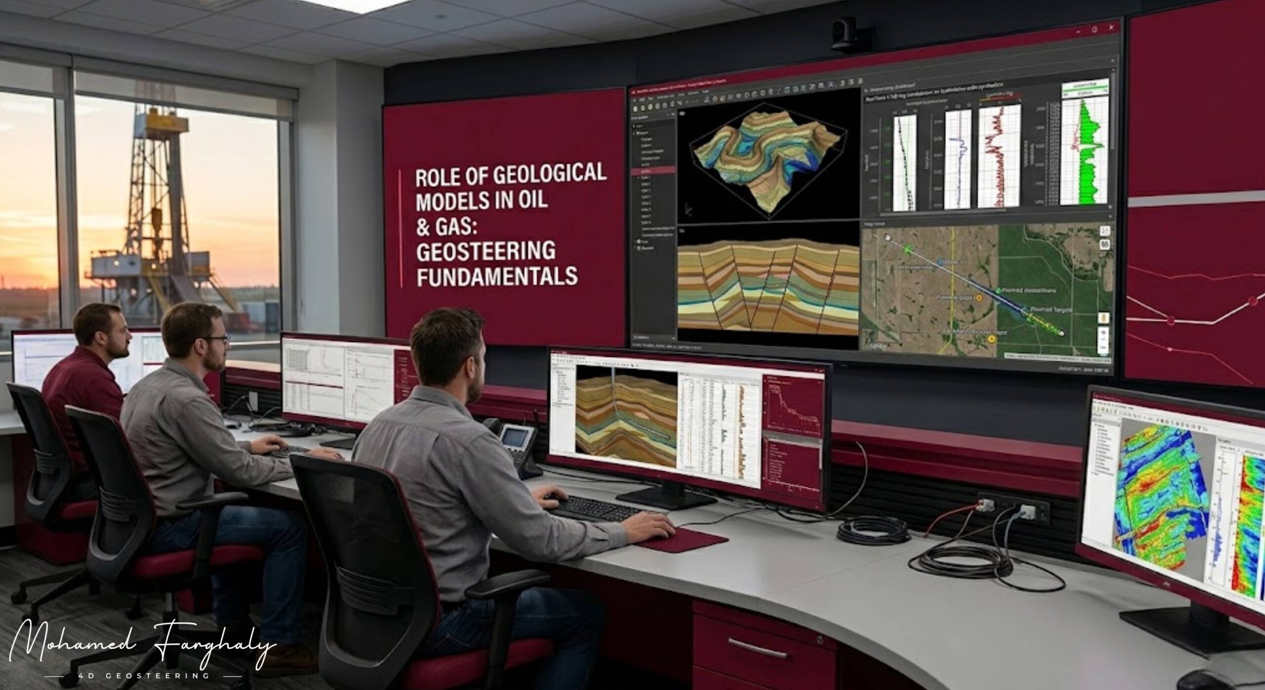
    Geological models are the backbone of almost every decision made in oil and gas exploration and development. They represent a structured interpretation of the subsurface and help transform scattered geological, geophysical, and petrophysical data into a coherent 3D understanding of the reservoir.

    In simple terms, a geological model is the bridge between what we know from data and what actually exists underground.


    What is a Geological Model?

    A geological model is a 3D digital representation of subsurface formations. It integrates different types of data such as:

    • Seismic interpretation
    • Well logs
    • Core data
    • Stratigraphic and structural analysis

    The goal is to define reservoir geometry, properties, and continuity in space.


    Why Geological Models Are Important

    Geological models play a critical role in all stages of oil and gas development:

    1. Exploration Stage

    During exploration, geological models help identify potential hydrocarbon traps, predict reservoir presence, and reduce uncertainty before drilling begins.

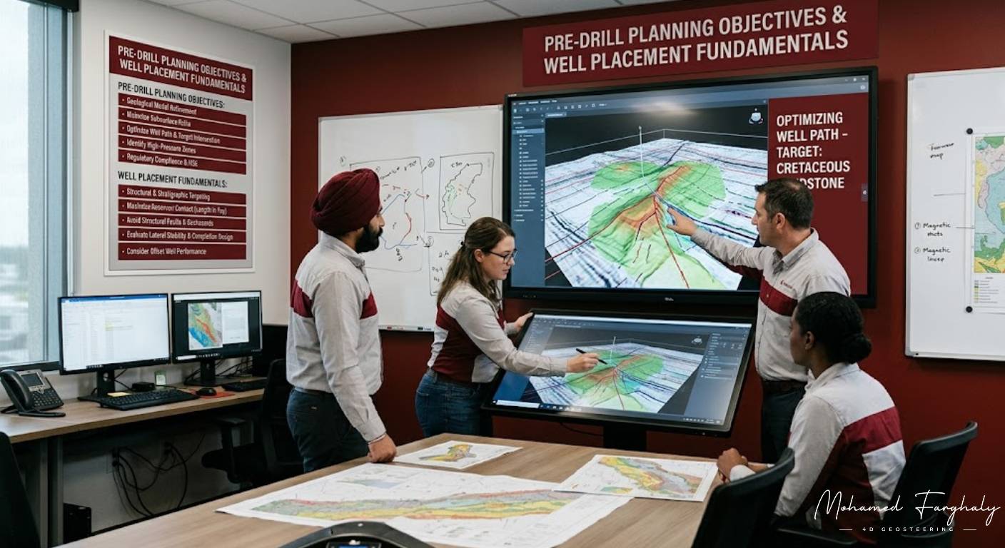
    2. Development Planning

    Once a discovery occurs, asset teams use the model to design well locations, estimate reserves, and plan field development strategies.

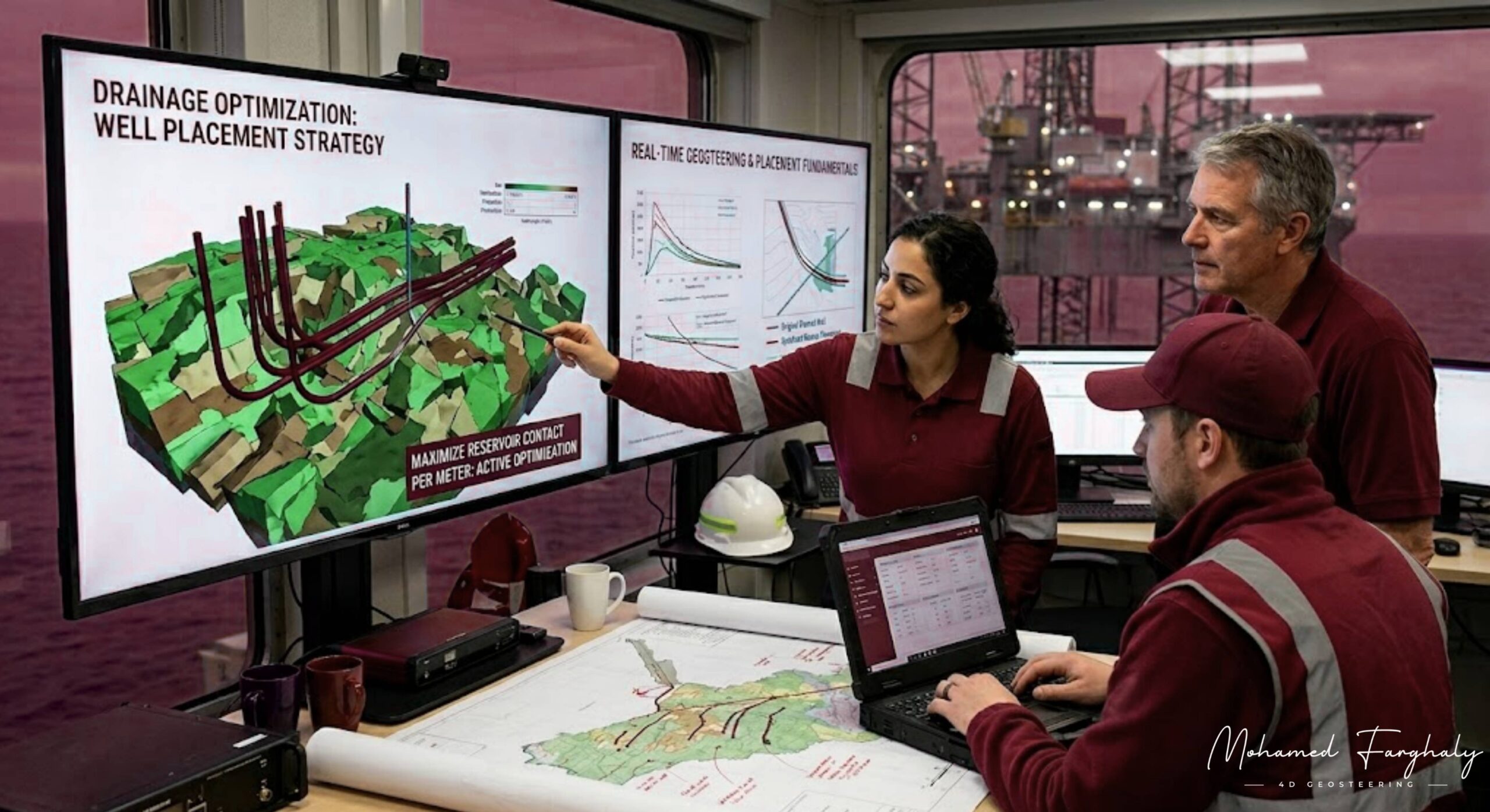
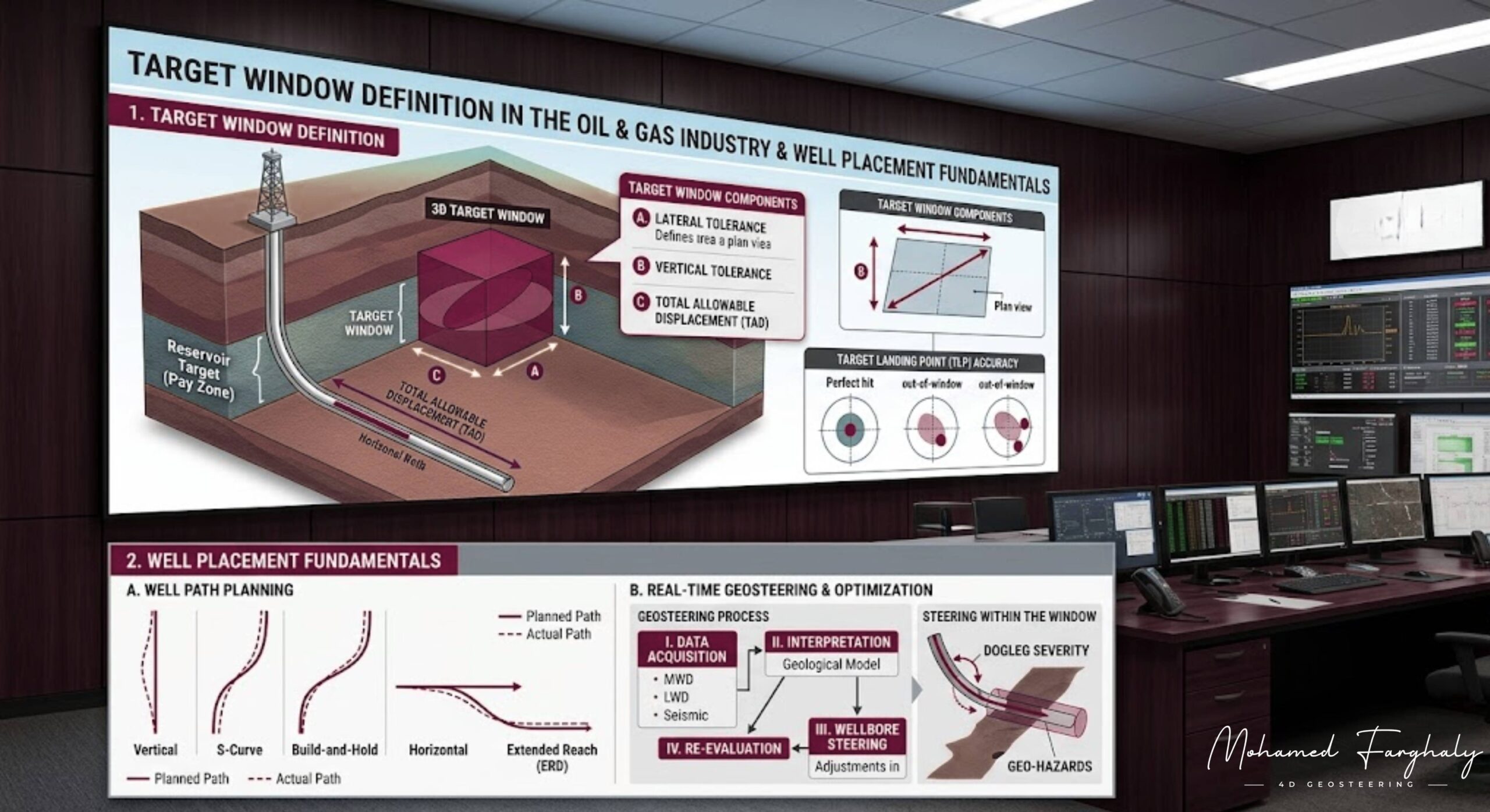
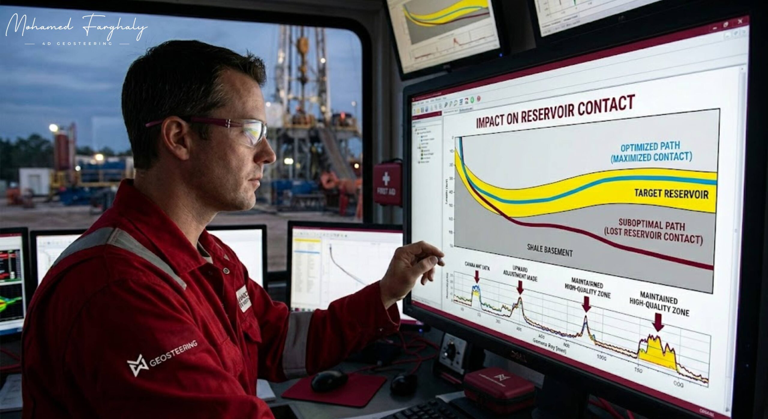
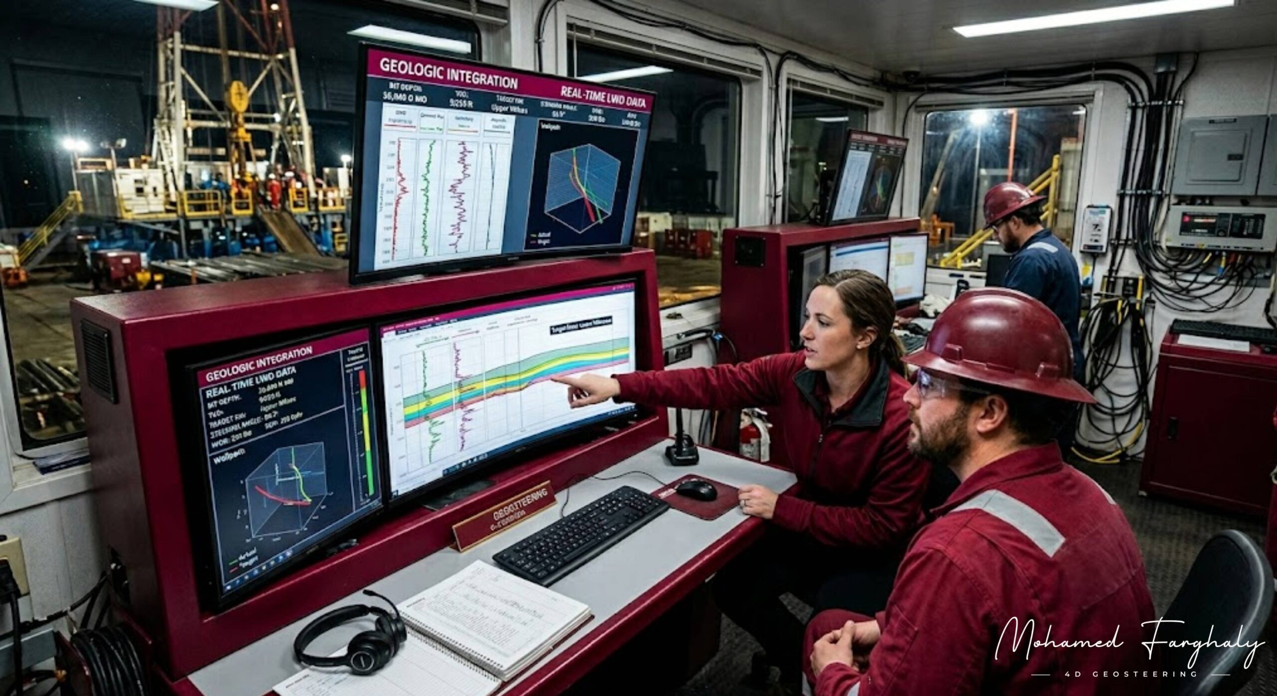
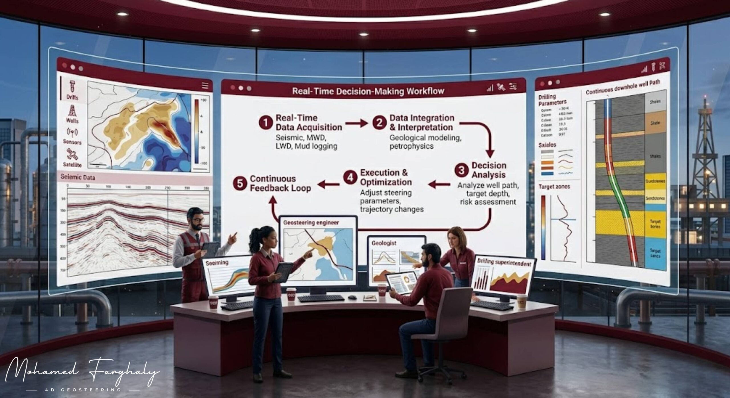
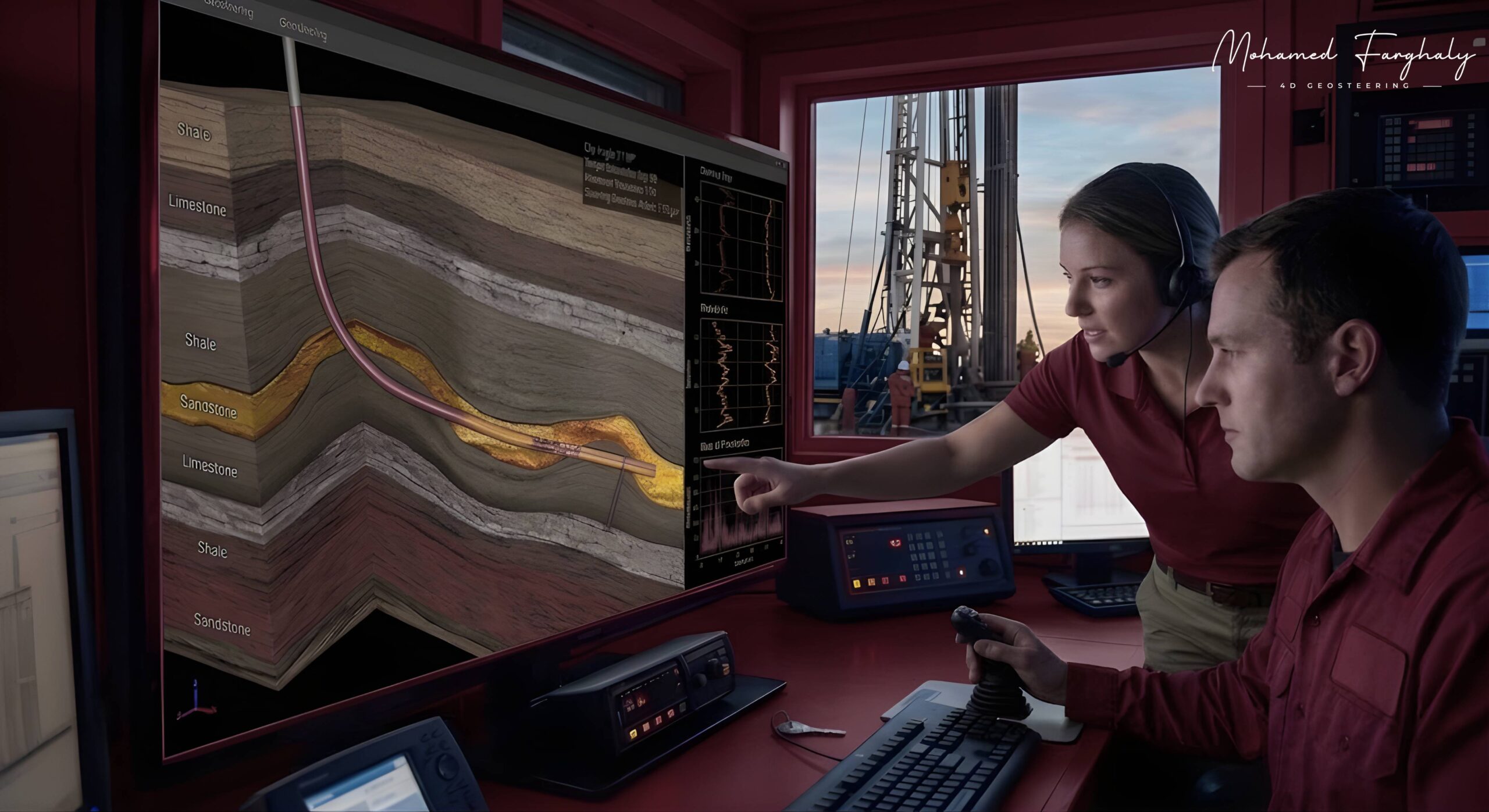
    3. Drilling and Geosteering

    In real-time operations, especially in geosteering, geological models act as the initial reference for well placement. As new data comes in while drilling, the asset team continuously updates the model to reflect the true subsurface conditions.

    4. Production Optimization

    After operators drill the wells, they use the model to simulate reservoir behavior, optimize production strategies, and enhance recovery.


    Key Role in Geosteering

    One of the most critical applications of geological models is in real-time geosteering decisions. Before drilling, the model defines the expected position of the reservoir. However, subsurface uncertainty is always present.

    As drilling progresses:

    • The geosteering team compares LWD/MWD data with the initial model.
    • Geologists identify differences between prediction and reality.
    • The team updates the framework dynamically.
    • The directional driller adjusts the well path accordingly.

    This continuous interaction makes the geological model a living system, not a static interpretation.


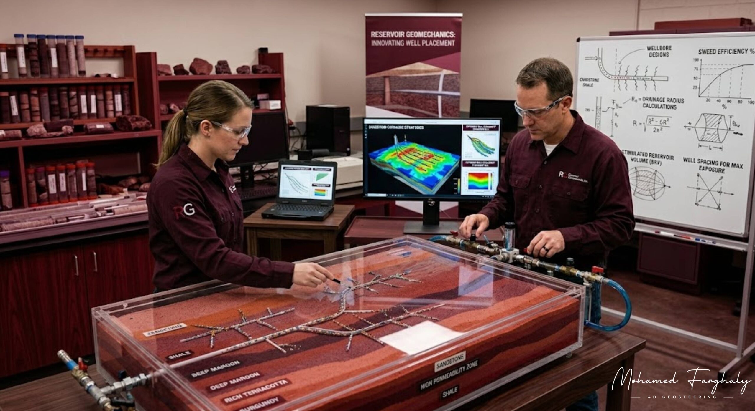
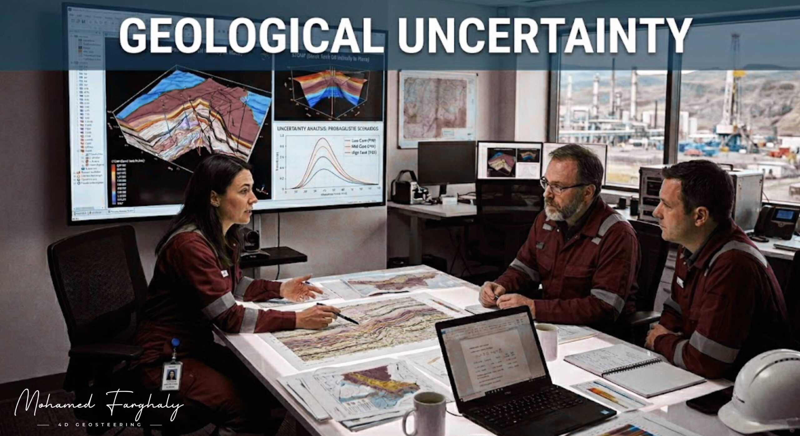
    Challenges in Geological Modeling

    Despite their importance, geological models face several challenges:

    • Limited and uneven data distribution
    • High subsurface uncertainty
    • Complex faulted or layered structures
    • Scaling issues between static models and real-time data

    Because of this, modern workflows increasingly rely on ensemble modeling, uncertainty quantification, and AI-driven updates to improve accuracy.


    🔗 Keywords

    Drilling Rig, Drilling Mud, MWD, LWD, Directional Drilling, Geosteering, Well Placement, Oil Reservoir, Surface Logging, Borehole Imaging, Electromagnetic Resistivity LWD Tool, Bottom Hole Assembly, Study of Real-Time LWD Data, LWD Interpretation, Borehole Image Log, Dip Calculation Methods, Shale Gas Sweet Spot, Accurate Reservoir Boundary Detection, Machine Learning, Artificial Intelligence, The Future of Automated Geosteering, Ensemble-Based Well Log Interpretation, Digital Twins in Drilling, Remote Operations Centers


  • Integration with Drilling Operations: Real-Time Team Workflows

    April 10, 2023· 2 minutes reading

    Integration with drilling operations means connecting geology, geophysics, and drilling engineering into one continuous workflow during well execution. Instead of each discipline working separately,sset teams share all data and decisions in real time. This collaborative effort guides the well toward the target zone efficiently.

    Before drilling begins, integration starts in the planning phase. Geoscientists and drilling engineers work together to build the geological and structural model, design the well trajectory, identify possible drilling risks such as faults or pressure zones, and select the appropriate drilling tools and Bottom Hole Assembly (BHA). This early coordination ensures that everyone involved in the operation is aligned with the same subsurface understanding and drilling plan.

    During drilling, real-time data becomes the key element of integration. Tools such as MWD and LWD continuously transmit information to the surface. This data includes wellbore direction, inclination, and formation properties. This includes wellbore direction (inclination and azimuth), formation properties such as gamma ray, resistivity, and density, as well as drilling performance indicators like rate of penetration, torque, and weight on bit. All this information is shared instantly between the drilling and geology teams.

    At this stage, continuous communication between teams is critical. Geologists and drilling engineers work together to build the geological model. During this phase, they design the well trajectory and identify possible drilling risks such as faults. Finally, they select the appropriate tools. Based on this interpretation, they decide whether any adjustments to the well path are needed.

    The rig crew immediately translates these engineering decisions into physical action at the site. Drilling engineers adjust parameters such as toolface orientation, inclination, azimuth, drilling speed, and weight on bit to correct the well trajectory. This ensures that the crew applies geological interpretation directly to physical drilling operations.

    Integration with drilling operations is important because it improves well placement accuracy, reduces geological uncertainty, minimizes non-productive time, helps avoid drilling into unwanted formations, and increases reservoir exposure and overall efficiency.


    🔗 Keywords

    Drilling Rig, Drilling Mud, MWD, LWD, Directional Drilling, Geosteering, Well Placement, Oil Reservoir, Surface Logging, Borehole Imaging, Electromagnetic Resistivity LWD Tool, Bottom Hole Assembly, Study of Real-Time LWD Data, LWD Interpretation, Borehole Image Log, Dip Calculation Methods, Shale Gas Sweet Spot, Accurate Reservoir Boundary Detection, Machine Learning, Artificial Intelligence, The Future of Automated Geosteering, Ensemble-Based Well Log Interpretation, Digital Twins in Drilling, Remote Operations Centers


  • Step-by-Step Real-Time Geosteering Workflow (Rig to Office)

    Jan 10, 2023· 2 minutes reading

    In modern oil and gas drilling, especially in horizontal wells, success depends less on following a fixed plan and more on real-time decision-making. This is the foundation of geosteering, where the well path is continuously adjusted using real-time subsurface data to keep the borehole inside the most productive part of the reservoir.

    Geosteering turns drilling into a dynamic, data-driven process where every drilled meter can change the next decision.


    What is Real-Time Decision-Making in Geosteering?

    Real-time decision-making is a continuous loop that connects data, interpretation, and action during drilling. Instead of waiting until the end of drilling to evaluate results, engineers and geoscientists interpret data instantly and adjust the well trajectory on the fly.

    The process includes:

    • Collecting downhole data while drilling
    • Interpreting formation signals in real time
    • Updating the geological model continuously
    • Making immediate steering decisions

    The goal is to keep the wellbore within the target reservoir sweet spot despite geological uncertainty.


    The Geosteering Workflow

    1. Pre-Drilling Model

    Before drilling starts, a geological model is built using seismic data, offset wells, and structural interpretation. This model predicts reservoir geometry, thickness, and boundaries, but it always contains uncertainty.


    2. Real-Time Data Acquisition

    While drilling, tools like Logging While Drilling (LWD) and Measurement While Drilling (MWD) continuously collect formation data such as gamma ray, resistivity, and density. This provides a real-time view of the formations surrounding the drill bit.


    3. Real-Time Interpretation

    The incoming data is compared with the expected model. Geoscientists interpret formation changes, identify boundaries, and detect whether the well is moving toward or away from the target zone. The model is updated continuously to reduce uncertainty.


    4. Decision and Steering

    Based on interpretation, the team makes immediate decisions:

    • Continue drilling in the same direction
    • Adjust inclination or azimuth
    • Correct the well path to stay within the reservoir

    This decision cycle repeats every few meters drilled.


    The Closed-Loop System

    Geosteering operates as a closed feedback loop:

    Predict → Drill → Measure → Interpret → Update → Decide → Repeat

    Each loop improves understanding of the subsurface and increases drilling accuracy in real time.


    Why It Matters

    Real-time decision-making in geosteering is critical because it:

    • Maximizes reservoir exposure and production
    • Avoids drilling into non-productive zones like shale or water
    • Reduces drilling risks and costly errors
    • Improves overall well placement efficiency

    Even small trajectory adjustments can significantly impact production performance.


    🔗 Keywords

    Drilling Rig, Drilling Mud, MWD, LWD, Directional Drilling, Geosteering, Well Placement, Oil Reservoir, Surface Logging, Borehole Imaging, Electromagnetic Resistivity LWD Tool, Bottom Hole Assembly, Study of Real-Time LWD Data, LWD Interpretation, Borehole Image Log, Dip Calculation Methods, Shale Gas Sweet Spot, Accurate Reservoir Boundary Detection, Machine Learning, Artificial Intelligence, The Future of Automated Geosteering, Ensemble-Based Well Log Interpretation, Digital Twins in Drilling, Remote Operations Centers


  • What is Geosteering and Why Does it Matter?

    April 10, 2023 · 2 minute reading


    🔗 Keywords